Loading...

🎉 Enjoy a Free 7-Day Supporter Trial and Unlock Exclusive Perks — No Credit Card Required. Learn more.

Burke Lake Loop Hike

Directions
Map
Pictures
Send to App
Distance:
5.2 Miles / 8.4 km
Type:
Loop
Difficulty:
Moderate
Time to Hike:
2 hours, ~36 minutes
Features:
Surface Type:
Dirt
Town:
South Run, Virginia
Directions:
38.760392, -77.302672
Added:
April 03, 2025
Updated:
April 06, 2025
Copy Trail Link Hiking this trail? Send a friend or family member a link to this trail guide for your own safety. Hike at your own risk (disclaimer)
Loading...
Loading...
20'

Total Change
68'

Ascent
73'

Descent

Download the Trail Route for Offline Use

Supporters get exclusive access to download trail routes to the MyHikes app for offline use. Stay prepared on your adventure, even without an internet connection! Become a Supporter today to unlock this feature and hike with confidence.

Send to App

Burke Lake Loop Hike

The land that Burke Lake Park now occupies was originally slated for an international airport in the 1950's, before the site was changed to what is now Dulles Airport. The park is 888 acres, with the lake at 218 acres. This hike primarily uses the main lake perimeter trail, plus several sections following unofficial hiking trails closer to the banks of the lake. The park is very popular with local residents, with the main trail used by runners, hikers, as well as mountain bikers.

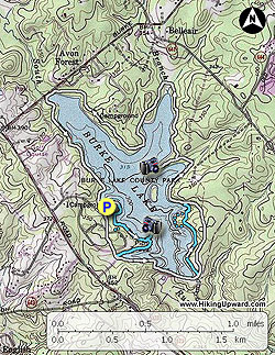
The map trails are marked in 2 colors. Light blue designating unofficial trails near the lake, and light grey for the main lake perimeter trail. The wide lake perimeter trail is paved in several places close to the marina.

  • Mile 0.0 – Start the hike from the marina parking area and head towards the snack bar and boat rental shed. Follow the narrow paved road around the back of the shed for 75 yards, then look for a faint unmarked trail that leads off the road towards the lake. This trail continues around the lake perimeter passing picnic benches as well as side trails back to the parking area and main park road.
  • Mile 0.67 - Arrive at a side trail that goes out to a view point and bench. Continue along the trail around the lake and enter a small inlet with fishing piers visible on the opposite bank. Pass a parking area on the right, and stay left on the narrow trail until it arrives at the paved main lake perimeter trail at the inlet headwater.
  • Mile 1.06 - Turn left on the main paved trail passing a boat ramp and parking area. The paved perimeter trail will pass 4 handicap accessible fishing piers then becomes dirt as it winds around to the lake dam.
  • Mile 1.37 - Cross the dam, then 40 yards arrive at a 4 way intersection with another unofficial side trail.
  • Mile 1.65 - Turn left on the narrow unofficial trail as it follows the banks of Burke Lake. The trail splits at a small rise. Turn right following the trail around a point, then turn right at the lake through a swampy area, then shortly the trail will end where it meets the wide perimeter trail.
  • Mile 2.21 - Turn left on the perimeter trail. For the remainder of the hike remain on the official perimeter trail.
  • Mile 2.96 - Arrive at the intersection of a side trail on the left that leads out to the main view on the lake. There is a bench with views of the the dam and marina. Return to the main perimeter trail and continue left. From this point the perimeter trail passes multiple side access trails on the right as it continues around the lake. The 1.5 miles before reaching Burke Lake Rd. has been made into a fitness course.
  • Mile 4.59 - Stay left on the trail parallel to the access road, then at the far side stay left on the trail. For the remaining 0.6 miles back to the marina the trail passes the park train, an amphitheater, and frisbee golf.
  • Mile 5.2 - Arrive back at the marina parking area.
Explore 16 trails near South Run, VA
  1. Parking

    38.760392, -77.302672
  2. Main Trailhead

    38.760392, -77.302672
No community routes found. To add your own hike as a Community Route for this Trail guide, leave a Trip Report with an attached GPX file.

Hazards

Ticks - Lyme Disease More Info (CDC)
Poison Ivy/Oak

Seasons

All

Trip Reports

Trail Guide By:
HikingUpward user profile picture
5.2 miles / 8.4 km

Weather Forecast

In South Run, VA

Explore Hiking Trails

You May Also Like

New York's Best Waterfalls - Whether you're planning a day hike, roadside stop, or a leisurely short walk, this guide provides hikers, travelers, and locals alike with 63 different locations to over 100 scenic waterfalls to help plan your next adventure!
Explore

New York's Best Waterfalls

Whether you're planning a day hike, roadside stop, or a leisurely short walk, this guide provides hikers, travelers, and locals alike with 63 different locations to over 100 scenic waterfalls to help plan your next adventure!

Read
25 Best Day Hikes in North Carolina - Discover the top 25 best day hikes in North Carolina, from breathtaking waterfalls to mountain peaks. Explore hidden gems, scenic views, and trails suitable for all skill levels, perfect for your next outdoor adventure.
Explore

25 Best Day Hikes in North Carolina

Discover the top 25 best day hikes in North Carolina, from breathtaking waterfalls to mountain peaks. Explore hidden gems, scenic views, and trails suitable for all skill levels, perfect for your next outdoor adventure.

Read

Before you boogie...

Find our trail guides useful? Consider becoming a Supporter to unlock perks!

MyHikes is an indie platform that makes exploring public trails easier for everyone. The platform has no investors, no ads, and is owned and operated by one person, Dave Miller. Dave has personally mapped and written over 1,800 trail guides on MyHikes for the public to explore. MyHikes has helped millions outdoor enthusiasts plan their next adventure.

But it takes a lot of time 🕦, money 💰, work, and espresso shots ☕ to run MyHikes, including hiking , mapping , writing , and publishing new trails with high-quality (accurate) information... along with software engineering (coding) the platform like building new features, website and mobile app development (iOS and Android), site maintainance . and much much more.

Supporters unlock website and mobile app perks with an annual one-time payment of $25 (you renew) 😎👍. Or you can simply make a Donation of your choice. Otherwise, you can support us by telling your friends about MyHikes - both quick and free 🎉

Admin user profile picture

Dave Miller
MyHikes Founder