Loading...

❄️ WINTER SALE! 50% OFF on Supporter Accounts — now through January 31st. Unlock a full year of exclusive website & app perks. Learn More.

Buck Hollow and Mary's Rock Hike

The Buck Hollow/Mary's Rock loop in the SNP can be broken into two hikes; or done as one large loop. The Buck Hollow/Buck Ridge main portion of the hike offers much more solitude than the section from Skyline Drive up to Mary's Rock. However, both offer great scenery.

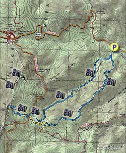
From the parking area on US211 head up the Buck Hollow Trail crossing Buck Hollow stream and in 0.2 miles come to the intersection of the Buck Ridge Trail. Stay right remaining on the blue blazed Buck Hollow Trail.

The Buck Hollow Trail climbs the valley crossing the stream several times before becoming steeper and arriving at Skyline Drive and the Hazel Mountain parking area. At this point you can either continue up to Mary's Rock or shorten the hike by 3.0 miles and turn left on the yellow blazed Hazel Mountain Trail.

To continue up to Mary's Rock cross Skyline Drive, walk 50 yards left uphill and turn right onto the Meadow Spring Trail. Head uphill on the Meadow Spring Trail for 0.6 miles passing ruins of an old homestead about halfway before meeting the intersection of the white blazed Appalachian Trail and ridge line.

Turn right on the AT following it for 0.8 miles before arriving at the junction of the Mary's Rock Lookout Trail. Turn left uphill on the Mary's Rock Lookout Trail for 0.1 miles and come to the Mary's Rock vista.

To return, retrace your steps back along the AT and down the Meadow Spring Trail to the Hazel Mountain parking area on Skyline Drive. To continue stay right through the closed gate onto the yellow blazed Hazel Mountain Trail and in 0.5 miles come to the intersection of the Buck Ridge Trail.

Go straight on the blue blazed Buck Ridge Trail as it continues downward on Buck Ridge. The last 0.5 miles of the Buck Ridge Trail is very steep on loose rock so watch your footing. Arrive back at the intersection of the Buck Hollow Trail you ascended earlier 2.5 miles from where you left the Hazel Mountain Trail.

Turn right on the Buck Ridge Trail and arrive back at US211 and the parking area in 0.2 miles.
Explore 87 trails near Sperryville, VA

Know Before You Go

  • The Buck Hollow/Mary's Rock loop in Shenandoah National Park is a 9-mile hike that can be shortened by 3 miles by taking the Hazel Mountain Trail.
  • The Buck Hollow and Buck Ridge trails offer more solitude compared to the section near Skyline Drive leading to Mary's Rock.
  • The route to Mary's Rock involves multiple trail transitions (Meadow Spring Trail, Appalachian Trail, Mary's Rock Lookout Trail) and includes notable landmarks like stream crossings, old homestead ruins, and a steep descent with loose rock on the Buck Ridge Trail.
Interactive topographic map for Buck Hollow and Mary's Rock Hike located in Sperryville, VA. Click the "View Map" button to load GPS coordinates and trail markers.
Get directions
Distance
9.0 mi
Difficulty
Hard
Type
Loop
Est. Time
4.5 hrs
Elev. Gain
2,632'
Rating
4.0
Added
March 18, 2025
Updated
April 05, 2025

Weather Forecast

Tonight
Low 36°F
Mostly Cloudy
Wednesday
High 46°F
Chance Light Rain
Wednesday Night
Low 16°F
Chance Rain And Snow
Thursday
High 24°F
Mostly Sunny
Thursday Night
Low 12°F
Mostly Clear
Friday
High 30°F
Mostly Sunny
Friday Night
Low 22°F
Partly Cloudy
Saturday
High 37°F
Slight Chance Light Snow
Saturday Night
Low 16°F
Slight Chance Light Snow then Partly Cloudy
Sunday
High 24°F
Mostly Sunny
Sunday Night
Low 12°F
Partly Cloudy
M.L. King Jr. Day
High 29°F
Mostly Sunny
Monday Night
Low 11°F
Partly Cloudy
Tuesday
High 23°F
Sunny
Loading...
Total Change
2,429'
Ascent
2,632'
Descent
2,642'
Loading...

Download the GPX Data for Offline Use

Supporters get exclusive access to download trail routes to the MyHikes app for offline use. Stay prepared on your adventure, even without an internet connection! Become a Supporter today to unlock this feature and hike with confidence.

Download Buck Hollow and Mary's Rock Hike GPX Data to the MyHikes Mobile App

Features

Vista / Lookout Point
Dogs
Mountain Summit
Camping
Water Source
Appalachian Trail logo Appalachian Trail hike

Points of interest

  1. Parking

    38.657885, -78.28085
  2. Main Trailhead

    38.658303, -78.281879

Safety information

For your own safety: plan ahead, let someone know where you'll be, and hike at your own risk.

Hazards

Snakes (Rattlesnakes, Copperheads, others)
Poison Ivy or Poison Oak

Markers

Blaze Color

Blue

Availability

All seasons

Surface type

Dirt

Trip Reports (Reviews)

Rated 4.01 out of 5 based on 76 ratings.

Ready to help fellow hikers? Add a trip report to share your experience and provide valuable insights for other hikers!

9.0 miles / 14.5 km
July 06, 2025
Ascent is 5/10 difficulty but pretty along stream. Small swimming hole halfway up. Marys rock not worth view. Whole thing is 4 hrs without stops
Hiking
By: Danieamell
9.0 miles / 14.5 km
June 24, 2017
Ran in to a bear on the trail less than half a mile from the summit. Keep an eye out. The lack of crowds made for an otherwise great hike.
Legacy Review
By: Danieamell
9.0 miles / 14.5 km
June 24, 2017
Ran in to a bear on the trail less than half a mile from the summit. Keep an eye out. The lack of crowds made for an otherwise great hike.
Legacy Review
No community routes found. To add your own hike as a Community Route for this Trail guide, leave a Trip Report with an attached GPX file.

Popular categories

Scenic mountain view representing vista trails
Vista trails
Scenic gorge of cascades representing waterfall trails
Waterfall hikes
Rugged mountain terrain representing summit trails
Summit trails
Scenic mountain view representing dog-friendly trails
Dog-friendly
Scenic campsite with a view representing camping trails
Camping trails
Appalachian Trail logo representing A.T. hikes
A.T. hikes

You May Also Like

25 Best Day Hikes in North Carolina - Discover the top 25 best day hikes in North Carolina, from breathtaking waterfalls to mountain peaks. Explore hidden gems, scenic views, and trails suitable for all skill levels, perfect for your next outdoor adventure.
Explore

25 Best Day Hikes in North Carolina

Discover the top 25 best day hikes in North Carolina, from breathtaking waterfalls to mountain peaks. Explore hidden gems, scenic views, and trails suitable for all skill levels, perfect for your next outdoor adventure.

Read
🍪 We use cookies to learn about site usage and to serve map tiles. You may block cookies manually in the browser. By continuing you agree. Learn more