Loading...

๐ŸŽ† 50%-off 4th of July sale on Supporter Accounts thru July 6th! Learn more

Bryce Point

Directions
Map
Pictures
Send to App
Distance:
0.3 Miles / 0.5 km
Type:
Out-and-Back
Difficulty:
Easy
Time to Hike:
~9 minutes
Features:
Surface Type:
Universal Access
Park:
Bryce Canyon National Park
Town:
Bryce Canyon City, Utah
Directions:
37.604069, -112.156647
Added:
September 25, 2023
Updated:
October 08, 2023
Copy Trail Link Hiking this trail? Send a friend or family member a link to this trail guide for your own safety. Hike at your own risk (disclaimer)
Loading...
Loading...
59'

Total Change
63'

Ascent
63'

Descent

Download the Trail Route for Offline Use

Supporters get exclusive access to download trail routes to the MyHikes app for offline use. Stay prepared on your adventure, even without an internet connection! Become a Supporter today to unlock this feature and hike with confidence.

Send to App

Bryce Point

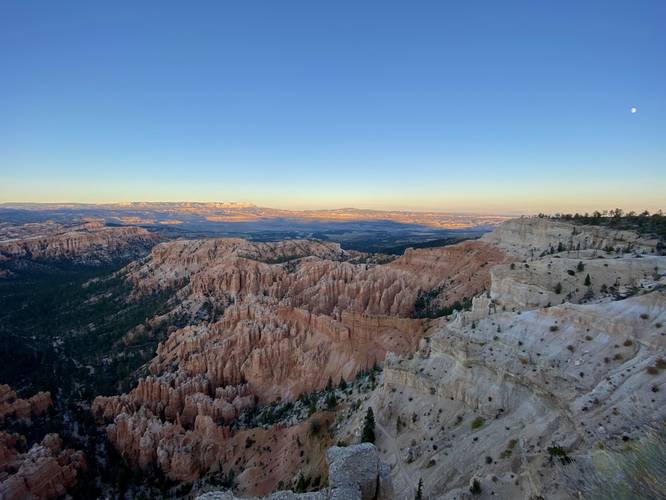
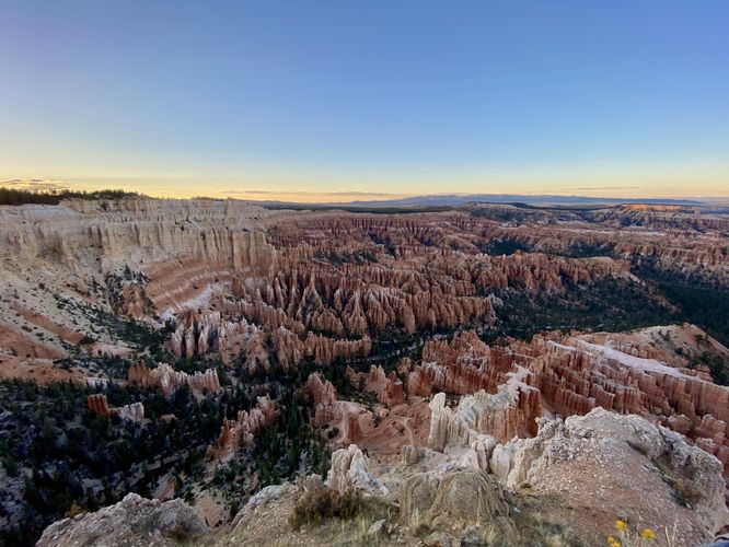
Bryce Point at Bryce Canyon National Park near Bryce Canyon City, Utah is an easy 0.3-mile universally-accessible out-and-back trail that leads to a popular and stunning panoramic view of Bryce Canyon and its hoodoos.

This short walk leads to one of the most popular destinations at Bryce Canyon, especially during sunrise and sunset where visitors will stake out a spot early to get the best views. No matter what time of day you visit Bryce Point, it'll be one of the best vistas you explore at the park and should be high on visitor's lists. Bryce Point follows a paved, universally-accessible trail, as it leads ~60-feet in elevation down to a rock ledge that juts into the canyon with extremely-steep sheer drops on three sides with panoramic views.

Universal Access: This trail includes a paved universal access pathway.

Fees: Bryce Canyon National Park has a $35/week entry fee as of September 2023. Visitors are highly encouraged to purchase an annual National Parks pass before their trip to reduce entry fees (especially if you're passing through multiple parks) and to also speed-up the very-long line that leads into the park.

Parking: Visitors will find a large parking lot at the coordinates provided.

Pets: Dogs are only allowed on paved surfaces at Bryce Canyon National Park like parking lots and fully paved trails, as of September 2023. Please read more about Bryce Canyon National Park's pet policy here.
Explore 25 trails near Bryce Canyon City, UT
  1. Parking

    37.604069, -112.156647
  2. Main Trailhead

    37.604276, -112.156839
  3. View into Bryce Canyon from the Bryce Point Trail

    37.605862, -112.157364
    View into Bryce Canyon from the Bryce Point Trail
  4. View into Bryce Canyon from the Bryce Point Trail

    37.605792, -112.157531
     View into Bryce Canyon from the Bryce Point Trail
No community routes found. To add your own hike as a Community Route for this Trail guide, leave a Trip Report with an attached GPX file.

Hazards

Snakes
Rockfalls / Ledges / or Scrambles

Seasons

All

Trip Reports

Trail Guide By:
Admin user profile picture
0.3 miles / 0.5 km
0.3 miles / 0.5 km
September 25, 2023
Hiking

Weather Forecast

In Bryce Canyon City, UT

Explore Hiking Trails

You May Also Like

Colorado's Million Dollar Highway - Plan a day's drive adventure along the iconic Million Dollar Highway in Colorado. Explore the best short trails, roadside stops, waterfalls, vistas, ghost towns, and hot springs within a ~6 hour road trip.
Explore

Colorado's Million Dollar Highway

Plan a day's drive adventure along the iconic Million Dollar Highway in Colorado. Explore the best short trails, roadside stops, waterfalls, vistas, ghost towns, and hot springs within a ~6 hour road trip.

Read
Glacier's Going-to-the-Sun Road - Discover the breathtaking beauty of Glacier National Park along the iconic Going-to-the-Sun Road. From stunning roadside stops to picturesque waterfalls and vistas, this engineering marvel offers endless opportunities for exploration.
Explore

Glacier's Going-to-the-Sun Road

Discover the breathtaking beauty of Glacier National Park along the iconic Going-to-the-Sun Road. From stunning roadside stops to picturesque waterfalls and vistas, this engineering marvel offers endless opportunities for exploration.

Read
New York's Best Waterfalls - Whether you're planning a day hike, roadside stop, or a leisurely short walk, this guide provides hikers, travelers, and locals alike with 63 different locations to over 100 scenic waterfalls to help plan your next adventure!
Explore

New York's Best Waterfalls

Whether you're planning a day hike, roadside stop, or a leisurely short walk, this guide provides hikers, travelers, and locals alike with 63 different locations to over 100 scenic waterfalls to help plan your next adventure!

Read

Before you boogie...

Find our trail guides useful? Consider becoming a Supporter to unlock perks!

MyHikes is an indie platform that makes exploring public trails easier for everyone. The platform has no investors, no ads, and is owned and operated by one person, Dave Miller. Dave has personally mapped and written over 1,800 trail guides on MyHikes for the public to explore. MyHikes has helped millions outdoor enthusiasts plan their next adventure.

But it takes a lot of time ๐Ÿ•ฆ, money ๐Ÿ’ฐ, work, and espresso shots โ˜• to run MyHikes, including hiking , mapping , writing , and publishing new trails with high-quality (accurate) information... along with software engineering (coding) the platform like building new features, website and mobile app development (iOS and Android), site maintainance . and much much more.

Supporters unlock website and mobile app perks with an annual one-time payment of $25 (you renew) ๐Ÿ˜Ž๐Ÿ‘. Or you can simply make a Donation of your choice. Otherwise, you can support us by telling your friends about MyHikes - both quick and free ๐ŸŽ‰

Admin user profile picture

Dave Miller
MyHikes Founder