Loading...

❄️ WINTER SALE! 50% OFF on Supporter Accounts — now through January 31st. Unlock a full year of exclusive website & app perks. Learn More.

Broad Hollow Hike

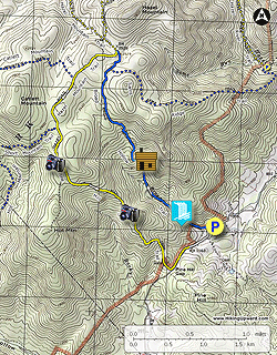
Hidden in a back corner of the Shenandoah National Park, the Broad Hollow/Pine Hill Gap hike offers a surprising amount of solitude nestled between Old Rag, Catlett, and Hazel Mountains. The hike starts along Broad Hollow Run with a pleasant set of cascades, then turns steeply uphill and passes the ruins of an old cabin. The flatter section in the Hazel/Catlett Mountain hollow has old growth Hemlock and Wild Oak, as well as an abundance of Mountain Laurel.

This is a great day-hike where you can avoid all the crowds on the more popular trails very close by. The best times of the year to enjoy this circuit are early spring and late fall when the leaves are off the trees providing nice views of Old Rag and Hazel Mountains. There are also 3 crossings of Broad Hollow Run, these are not difficult but may require rock hoping in the spring after winter snow melt.

  • Mile 0.0 - From the parking area on VA681/Rolling Rd. start the hike at the trail post on the right of the private driveway. Immediately cross Broad Hollow Run and follow the blue blazed Broad Hollow Run Trail on the right bank. Soon pass a small waterfall and cascade then arrive at the 2nd crossing. Now continue up the left back for 0.2 miles and cross Broad Hollow Run for the 3rd and final time. The trail will move away from Broad Hollow Run as it climbs one of the spurs off Sams Ridge.
  • Mile 1.0 - The trail becomes increasingly steep before making a turn back to the left and passing a seasonal spring. Shortly after the spring are remains of a cabin. After the cabin the Broad Hollow Trail will climb the ridge and turn back to the right. In 0.2 miles the trail levels out and passes through a thick area of Mountain Laurel the arrives at the intersection of the Sams Ridge Trail.
  • Mile 2.7 - Stay left remaining on the Broad Hollow Trail, cross the upper section of Sams Run, then the Broad Hollow Trail ends at the junction of the Hazel Mountain Trail.
  • Mile 2.9 - Turn left on the wider yellow blazed Hazel Mountain Trail as it passes through a small hollow then arrives at the Catlett Mountain Trail on the right in 0.5 miles. This section is full of hemlock and white oak.
  • Mile 3.4 - Continue straight on the Hazel Mountain Trail arriving at the intersection of the Hot Mountain/Short Mountain Trail in another 0.5 miles.
  • Mile 3.9 - Continue straight on the yellow blazed Hazel Mountain Trail where there are several views between the trees to the west and Skyline Drive. Shortly after passing the best viewpoint the trail arrives at an old trail marker for the closed Hot Mountain Trail and end of the Hazel Mountain Trail.
  • Mile 4.3 - From the old trail marker the Hazel Mountain Trail becomes the Pine Hill Gap Trail and steeply descends the ridge with Pine Hill Mountain visible directly ahead. There are views to the south of Old Rag Mountain, with the best views from the saddle on the ridge. From the saddle the Pine Hill Gap Trail is at its steepest before arriving at Pine Hill Gap.
  • Mile 5.3 - At Pine Hill Gap turn left following the old Pine Hill Gap forestry road. The forestry road is not maintained and can be boggy and overgrown. Stay on the forestry road until it ends at the Pine Hill Gap Trail sign and Rolling Rd.
  • Mile 5.9 - Continue along Rolling Road past several trailers for 0.3 miles back to the parking area at the Broad Hollow trailhead.
Explore 80 trails near Sperryville, VA

Know Before You Go

  • The Broad Hollow/Pine Hill Gap hike is a 5.9-mile loop in Shenandoah National Park near Sperryville, VA, offering a secluded experience away from crowded trails.
  • The trail features diverse scenery, including stream crossings, waterfalls, old cabin ruins, mountain laurel thickets, and views of Old Rag and Hazel Mountains, with best views in early spring and late fall.
  • The hike involves varied terrain, including steep ascents and descents, three stream crossings that may require rock hopping, and a section along an unmaintained forestry road that could be boggy.
Interactive topographic map for Broad Hollow Hike located in Sperryville, VA. Click the "View Map" button to load GPS coordinates and trail markers.
Get directions
Distance
5.9 mi
Difficulty
Moderate
Type
Loop
Est. Time
3 hrs
Elev. Gain
1,637'
Rating
3.3
Added
March 18, 2025
Updated
April 05, 2025

Weather Forecast

Tonight
Low 39°F
Mostly Cloudy
Wednesday
High 51°F
Chance Light Rain
Wednesday Night
Low 20°F
Chance Rain And Snow
Thursday
High 29°F
Sunny
Thursday Night
Low 15°F
Mostly Clear
Friday
High 34°F
Mostly Sunny
Friday Night
Low 25°F
Partly Cloudy
Saturday
High 41°F
Slight Chance Light Snow
Saturday Night
Low 19°F
Slight Chance Rain And Snow then Partly Cloudy
Sunday
High 28°F
Slight Chance Light Snow
Sunday Night
Low 15°F
Mostly Clear
M.L. King Jr. Day
High 34°F
Mostly Sunny
Monday Night
Low 14°F
Partly Cloudy
Tuesday
High 28°F
Sunny
Loading...
Total Change
1,495'
Ascent
1,637'
Descent
1,632'
Loading...

Download the GPX Data for Offline Use

Supporters get exclusive access to download trail routes to the MyHikes app for offline use. Stay prepared on your adventure, even without an internet connection! Become a Supporter today to unlock this feature and hike with confidence.

Download Broad Hollow Hike GPX Data to the MyHikes Mobile App

Features

Vista / Lookout Point
Dogs
Waterfalls
Camping
Water Source

Points of interest

  1. Parking

    38.594305, -78.271756
  2. Main Trailhead

    38.5942, -78.272095

Safety information

For your own safety: plan ahead, let someone know where you'll be, and hike at your own risk.

Hazards

Snakes (Rattlesnakes, Copperheads, others)
Poison Ivy or Poison Oak

Availability

All seasons

Surface type

Dirt

Trip Reports (Reviews)

Rated 3.31 out of 5 based on 26 ratings.

Ready to help fellow hikers? Add a trip report to share your experience and provide valuable insights for other hikers!

By: Brian Alexander
5.9 miles / 9.5 km
December 01, 2018
I hiked this on a foggy, drizzly Saturday with a small group from Central Virginia Trailblazers (www.cvatrailblazers.org). The description and recent reviews are spot on. The trail is mostly cleared as Jim Necci mentioned. We had no trouble finding the lone parking spot, which was vacant when we arrived. Due to recent rains, the stream crossings in the first mile were a little tricky and the forestry road near the end was more like a creek than a bog. I can't comment on the views as the fog was too thick to see anything. We saw no other hikers on the trail the entire day. Overall a very pleasant hike.
Legacy Review
By: JimNecci
5.9 miles / 9.5 km
July 13, 2018
A Broad Hollow update. The trails are all now cleared. Somebody did a heck of a lot of work. There were so many trees down in May it should have taken two men, a boy and a couple of horses. The size of some of the tree segments moved off of the trail were huge. And some of the work down with an ax. The hike was much easier this time.
Legacy Review
By: JimNecci
5.9 miles / 9.5 km
May 10, 2018
The trees mentioned in the previous review are still down across the trail. The first part of the hike someone has worked clearing the trail with chainsaws and an ax. When you are well into the hike you come to an area where MANY trees are down or broken. There are about five trees all broken and leaning together about 30-40 feet up. From that point none of the trail is cleared. There are many obstacles to go around, climb over, under or work your way through. It does lengthen the time and the distance somewhat. The uphill climbs and water crossings were a bit challenging, the 3 rating is probably right on. The parking is not as dire as some of the other reviews made it seem. We parked four vehicles without much problem. I enjoyed the hike, yes, I would do it again. One tick. Oh, and a bear just before the parking area.
Legacy Review
No community routes found. To add your own hike as a Community Route for this Trail guide, leave a Trip Report with an attached GPX file.

Popular categories

Scenic mountain view representing vista trails
Vista trails
Scenic gorge of cascades representing waterfall trails
Waterfall hikes
Rugged mountain terrain representing summit trails
Summit trails
Scenic mountain view representing dog-friendly trails
Dog-friendly
Scenic campsite with a view representing camping trails
Camping trails
Appalachian Trail logo representing A.T. hikes
A.T. hikes

You May Also Like

25 Best Day Hikes in North Carolina - Discover the top 25 best day hikes in North Carolina, from breathtaking waterfalls to mountain peaks. Explore hidden gems, scenic views, and trails suitable for all skill levels, perfect for your next outdoor adventure.
Explore

25 Best Day Hikes in North Carolina

Discover the top 25 best day hikes in North Carolina, from breathtaking waterfalls to mountain peaks. Explore hidden gems, scenic views, and trails suitable for all skill levels, perfect for your next outdoor adventure.

Read
🍪 We use cookies to learn about site usage and to serve map tiles. You may block cookies manually in the browser. By continuing you agree. Learn more