Bradford Falls and Lower Falls hike at State Game Lands 36 near Canton, Pennsylvania is a difficult 1.6-mile out-and-back hike that leads to the ~80-foot tall waterfall, Bradford Falls. The hike also includes several other waterfalls ranging from ~4-feet to 18-feet tall.
Trails
This hike follows a state game land trail that leads up Falls Creek. Note that the GPS data provided displays creek crossings, but technically the trail stays on the left-hand side of the creek the entire hike up which minimal drainage creek crossings along the way.
Hike Description
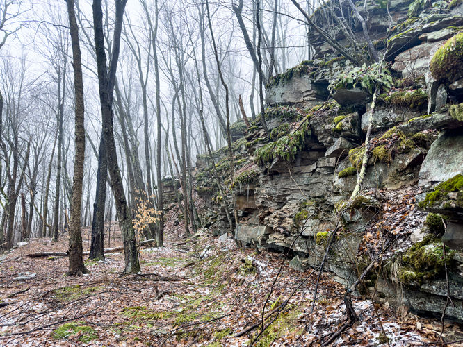
This hike begins along Schrader Creek Road at the coordinates provided and heads west along the road for a few-hundred feet to reach the trailhead, located on the north side of the road. Hikers will head up the trail as it begins the moderate ascent toward Bradford Falls. Eventually, the trail will skirt into the woods, heading off on a right-hand tangent from the main state game lands path. The trail will then meander through the woods, heading northward, as it passes a tributary creek - here, the trail becomes much more skinny and rocky, with undulating terrain.
Lower Cascades - Mile 0.5
Around mile 0.5, hikers will hear the sounds of the lower waterfalls cascading down the mountain; however, this guide will bring the hiker back to these waterfalls after visiting Bradford Falls first.
Reaching Bradford Falls - Mile 0.5 to 0.8
After passing the lower waterfalls section of the hike, between mile 0.5 and 0.8 can be a bit taxing as the terrain becomes a bit more challenging with lots of undulating forest floor and large rocks in-between that could easily twist an ankle, or worse. Along the way up is at least one 6-foot tall waterfall that sits just off-trail and can be enjoyed without putting in any additional hiking. Note that the worst of the terrain is just before the view of Bradford Falls, right around mile 0.75.
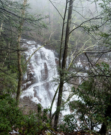
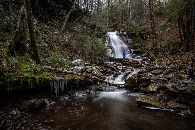
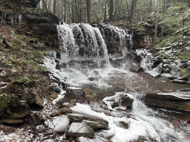
Bradford Falls, 80-feet Tall - Mile 0.8
Once you scramble over the last of the rocky terrain, you'll reach the 80-foot tall Bradford Falls around mile 0.8. Bradford Falls cascades down the steep shale bedrock at about 80-feet tall, but during low water hikers can even walk right up to the base of the waterfall. The views from downstream are stunning and this cascade should be appreciated for a while before turning back to explore the remaining waterfalls.
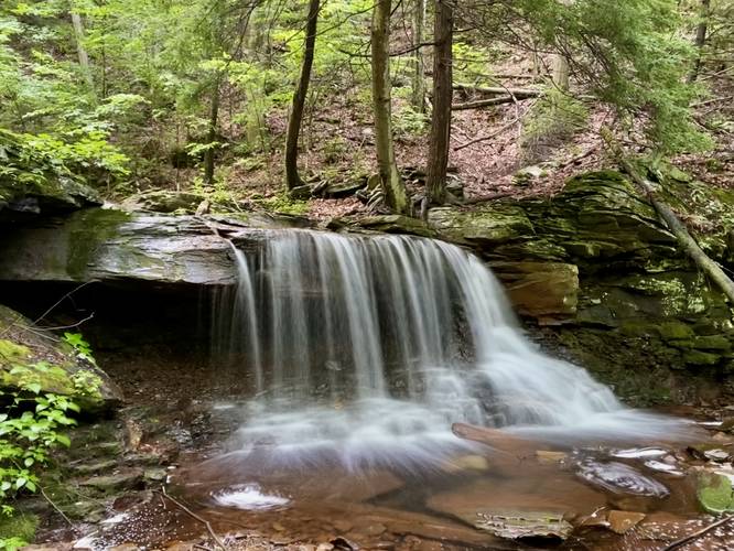
Lower Falls, 6-foot Tall Waterfall - Mile 0.9
Around mile 0.9, on the hike out, hikers will pass the same 6-foot tall waterfall they passed on the way in; however, after visiting Bradford Falls, hikers will have the time to head off-trail if they wish to sit and enjoy this beautiful cascade as well, albeit ~74-feet shorter than Bradford Falls.
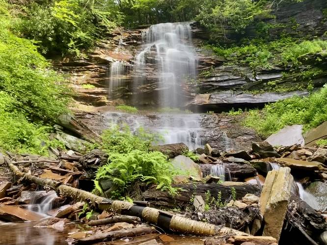
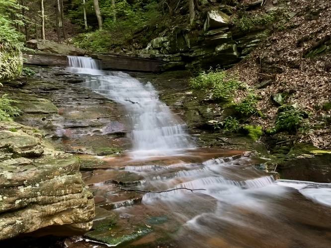
Lower Falls, ~18-foot Tall Waterfall - Mile 1
The exploration is not over, if you wish to explore more waterfalls. Hikers, if they head off-trail and follow Falls Creek heading south, they'll find a long multi-tiered waterfall that cascades down Falls Creek at about 18-feet tall in total. This waterfall is well-worth stopping at; however, photographers will find the best view located in the middle of the creek which is accessible during low water.
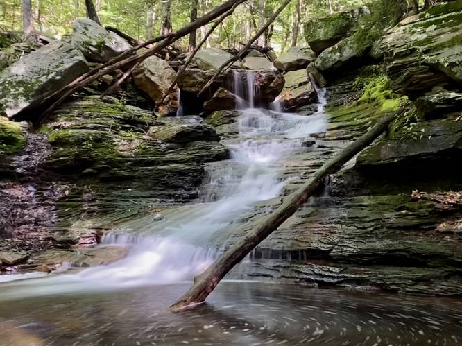
Lower Falls, ~12-foot Tall Waterfall - Mile 1.02
Just below the 18-foot cascade is another waterfall that spills down Falls Creek at about 12-feet tall. This waterfall has a 2-foot tall plunge with a ~10-foot tall slide that shoots the water down the creek's bedrock. After visiting this waterfall, the main points-of-interest are done and the hiker can head west again to reach the trail.
Hiking Out
After visiting all of the lower waterfalls, hikers will head out along the same path they hiked-in on, to complete this trek at just 1.6-miles. The elevation gain is ~500-feet, hence the "Hard" difficulty.
Parking
Hikers will find parking at the coordinates provided, at the junction of Falls Creek and Schrader Creek Road. The lot is large enough for just a few vehicles.
Pets
Dogs are allowed only if leashed and should be cleaned up after.
Warnings
Hunting: Hunting is permitted during specified open seasons. Wearing blaze orange is smart to avoid being shot.
Rough terrain: This hike follows some rough terrain, especially closer to Bradford Falls. Watch your step.
Trails
This hike follows a state game land trail that leads up Falls Creek. Note that the GPS data provided displays creek crossings, but technically the trail stays on the left-hand side of the creek the entire hike up which minimal drainage creek crossings along the way.
Hike Description
This hike begins along Schrader Creek Road at the coordinates provided and heads west along the road for a few-hundred feet to reach the trailhead, located on the north side of the road. Hikers will head up the trail as it begins the moderate ascent toward Bradford Falls. Eventually, the trail will skirt into the woods, heading off on a right-hand tangent from the main state game lands path. The trail will then meander through the woods, heading northward, as it passes a tributary creek - here, the trail becomes much more skinny and rocky, with undulating terrain.
Lower Cascades - Mile 0.5
Around mile 0.5, hikers will hear the sounds of the lower waterfalls cascading down the mountain; however, this guide will bring the hiker back to these waterfalls after visiting Bradford Falls first.
Reaching Bradford Falls - Mile 0.5 to 0.8
After passing the lower waterfalls section of the hike, between mile 0.5 and 0.8 can be a bit taxing as the terrain becomes a bit more challenging with lots of undulating forest floor and large rocks in-between that could easily twist an ankle, or worse. Along the way up is at least one 6-foot tall waterfall that sits just off-trail and can be enjoyed without putting in any additional hiking. Note that the worst of the terrain is just before the view of Bradford Falls, right around mile 0.75.
Bradford Falls, 80-feet Tall - Mile 0.8
Once you scramble over the last of the rocky terrain, you'll reach the 80-foot tall Bradford Falls around mile 0.8. Bradford Falls cascades down the steep shale bedrock at about 80-feet tall, but during low water hikers can even walk right up to the base of the waterfall. The views from downstream are stunning and this cascade should be appreciated for a while before turning back to explore the remaining waterfalls.
Lower Falls, 6-foot Tall Waterfall - Mile 0.9
Around mile 0.9, on the hike out, hikers will pass the same 6-foot tall waterfall they passed on the way in; however, after visiting Bradford Falls, hikers will have the time to head off-trail if they wish to sit and enjoy this beautiful cascade as well, albeit ~74-feet shorter than Bradford Falls.
Lower Falls, ~18-foot Tall Waterfall - Mile 1
The exploration is not over, if you wish to explore more waterfalls. Hikers, if they head off-trail and follow Falls Creek heading south, they'll find a long multi-tiered waterfall that cascades down Falls Creek at about 18-feet tall in total. This waterfall is well-worth stopping at; however, photographers will find the best view located in the middle of the creek which is accessible during low water.
Lower Falls, ~12-foot Tall Waterfall - Mile 1.02
Just below the 18-foot cascade is another waterfall that spills down Falls Creek at about 12-feet tall. This waterfall has a 2-foot tall plunge with a ~10-foot tall slide that shoots the water down the creek's bedrock. After visiting this waterfall, the main points-of-interest are done and the hiker can head west again to reach the trail.
Hiking Out
After visiting all of the lower waterfalls, hikers will head out along the same path they hiked-in on, to complete this trek at just 1.6-miles. The elevation gain is ~500-feet, hence the "Hard" difficulty.
Parking
Hikers will find parking at the coordinates provided, at the junction of Falls Creek and Schrader Creek Road. The lot is large enough for just a few vehicles.
Pets
Dogs are allowed only if leashed and should be cleaned up after.
Warnings
Hunting: Hunting is permitted during specified open seasons. Wearing blaze orange is smart to avoid being shot.
Rough terrain: This hike follows some rough terrain, especially closer to Bradford Falls. Watch your step.


_20250128144753UTC_small.jpg)