Loading...

Distance:
0 Miles / 0 km
Type:
Out-and-Back
Difficulty:
Easy
Time to Hike:
~5 minutes
Features:
Surface Type:
Universal Access
Park:
Grand Staircase-Escalante National Monument
Town:
Boulder, Utah
Directions:
37.772714, -111.422202
Added:
September 26, 2023
Updated:
October 04, 2023
Loading...
Loading...
27 '

Total Change
27 '

Ascent
27 '

Descent

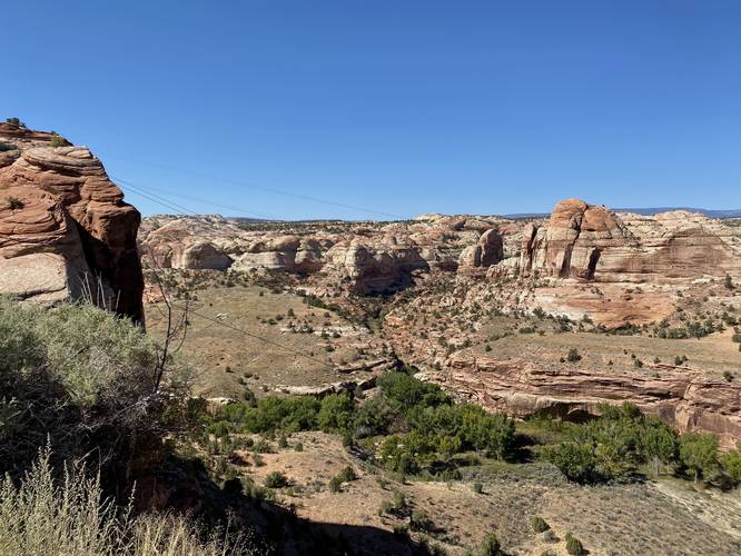
The Boynton Overlook at Grand Staircase-Escalante National Monument near Boulder, Utah is an easy roadside out-and-back walk that leads to a viewpoint above the Escalante River.

This is not a hike but rather a short roadside stop and walk along a universally-accessible paved parking turnout. At the parking turnout, visitors can walk the length of the safety fence to get different views of the surrounding area - mostly of the Escalante River and the towering rocks surrounding it.

Universal Access
This vista point has a universally-accessible paved path that reaches the viewing area. Note that this vista has a larger elevation grade, so it might not be the best wheelchair-accessible vista; however, visitors can enjoy the view from their vehicle for the most part.

Parking
Visitors will find a small parking turnout at the coordinates provided.

Pets
Dogs are allowed if leashed and must be cleaned up after.

Explore 12 trails near Boulder, UT
  1. Parking

    37.772714, -111.422202
  2. Main Trailhead

    37.772773, -111.422221
  3. Boynton Overlook view of the Escalante River

    37.772894, -111.421981
    Boynton Overlook view of the Escalante River
No community routes found. To add your own hike as a Community Route for this Trail guide, leave a Trip Report with an attached GPX file.

Hazards

Snakes
Rockfalls / Ledges / or Scrambles

Seasons

All

Photo Albums

2 Trip Reports

No Star-Ratings
Write-up by:
Admin user profile picture
0 miles / 0 km
Trail added
September 26, 2023
Hiked on
September 26, 2023
Updated on
October 04, 2023
0 miles / 0 km
September 26, 2023
Hiking

Weather Forecast

In Boulder, UT

Explore Hiking Trails

New Hikes

Lower Ammonoosuc Falls Trail
1.1 Miles
1.8 km
Easy
Out-and-Back
Angel Falls Loop
2.8 Miles
4.5 km
Moderate
Loop
Battery Warren Trail
1 Mile
1.6 km
Easy
Out-and-Back
Cold Run Waterfalls & Vista Loop
3.1 Miles
5 km
Moderate
Loop

Before you leave...

MyHikes is an indie web platform aimed to make exploring public trails easier for everyone. The site has no investors and is owned and operated by one person, Dave Miller (Founder & Admin). As the Founder, main contributor, and doer-of-all-things for MyHikes, I share my trips with over-detailed write-ups for fun on a volunteer basis and I believe that public trail information should be available to everyone.

It takes a lot of time 🕦, money 💰, and effort (including espresso shots ☕) to run MyHikes, including hiking , mapping , writing , and publishing new trails with high-quality content... along with building new features, moderating, site maintainance, and app development for iOS and Android . I simply ask that if you find MyHikes' trail guides helpful to please consider becoming a Supporter to help keep the site, iOS, and Android apps available to everyone.

Supporters unlock website and in-app perks with a one-time payment of $25 (you renew) 😎👍. Or you can simply make a Donation of your choice without a MyHikes user account. Otherwise, telling your friends about MyHikes is the next-best thing - both quick and free 🎉

Thanks for visiting MyHikes and have a great hike!️

Admin user profile picture

Dave Miller
MyHikes Founder & Admin