Boone Run Falls at Tioga State Forest in Blossburg, Pennsylvania is a moderate 1.5-mile out-and-back hike that leads to the multi-tiered 13-foot waterfall known as Boone Run Falls.
Trails
This hike follows the official, unblazed, and multipurpose Boone Run Trail before it heads off on a short bushwhack to find a different unnamed trail that follows the creeks banks.
Hike Description
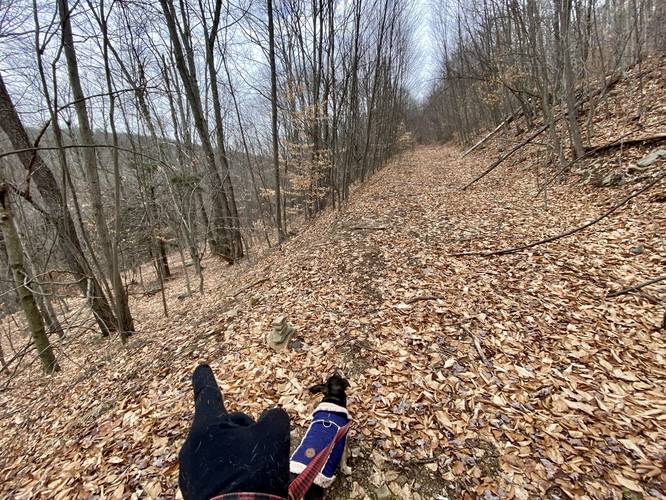
This hike begins on the off-ramp of PA-15 for the Blossburg exit (southbound) and heads into the woods. As of December 2022, there's a metal fence that's been pushed down at the trailhead; however, all of the land from the off-ramp to the trailhead is technically public land. Cross the fence line and you're already in Tioga State Forest. Follow the unmaintained Boone Run Trail uphill for 0.17-miles before taking a turn.
Left-Hand Turn - Mile 0.17
At mile 0.17, as of December 2022, there's a rock cairn and orange ribbons tied to trees that lead downhill to Boone Run creek. Follow this bushwhack for a just a short while before reaching the creek. Once at Boone Run, follow the unnamed and unblazed trail that heads uphill along its banks.
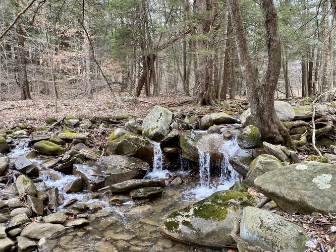
Small Waterfall - Mile 0.3
At mile 0.3 lies a very small waterfall, approximately 2-feet tall, that cascades down over some large rocks that sit in Boone Run. This small, free-falling waterfall, is not much to see, but is a pleasant surprise on the way to the larger Boone Run Falls.
Fishing Hole / Cascade - Mile 0.7
At mile 0.7 is another "waterfall", however, this one appears to be human-made as a tree was felled across the creek, causing a 2-foot tall and 15-foot wide cascade to pour over the downed tree and into the creek below - causing a churn of water. Fish love this and thus, this small cascade appears to be a fishing hole as the pool below is considerably deeper than the rest of the creek.
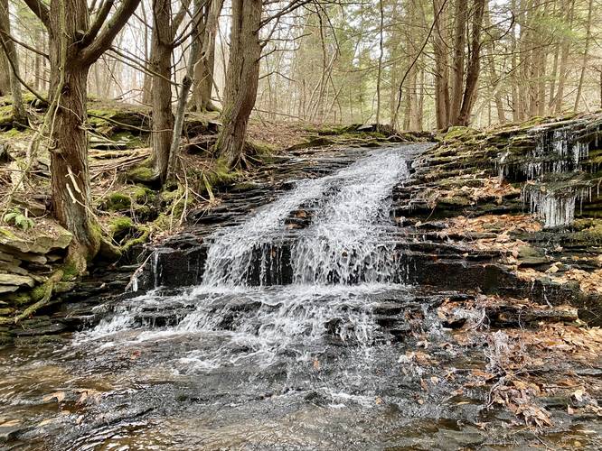
Upper Boone Run Falls - Mile 0.75
At mile 0.74, hikers will notice a convergence of a tributary creek and Boone Run creek. Here is also where you'll notice the Upper portion of Boone Run Falls, aka Upper Boone Run Falls. This section of Boone Run Falls is by far the largest as the water cascades down the bedrock at about 9-feet in total. Just below Upper Boone Run Falls is the convergence of the two creeks and even more bedrock with very small cascades. Just below, is Lower Boone Run Falls.
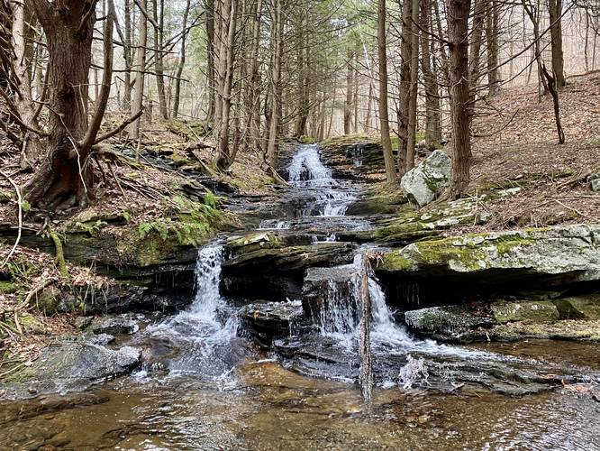
Lower Boone Run Falls - Mile 0.77
After visiting Upper Boone Run Falls, hikers will want to check out the view from the lower portion of the waterfall. Take a quick walk downhill to the 4-foot tall Lower Boone Run Falls, which sits just below the convergence of where the tributary creek spills into Boone Run. Viewing the waterfalls upstream from this view point, hikers will see approximately 13-feet of waterfalls which includes both Upper and Lower Boone Run Falls, which combined, makes up Boone Run Falls.
Parking
Please note that the parking coordinates for this hike lead you to a highway off-ramp for PA-15 at the South-bound exit for Blossburg. Hikers can actually park their vehicles at the end of Boone Run Rd to hike into the woods from there (near the coordinates: 41.674205, -77.078478). You can also park at the end of Boone Run Rd and hike up along the grass off of the highway off-ramp to this trailhead as well.
Pets
Dogs are allowed if leashed and their waste should be carried out by the hiker.
Camping & Backpacking
While there are no campsites along this hike, Tioga State Forest does allow primitive / dispersed / backcountry camping. Please follow all state forest rules and regulations when camping on state land.
Trails
This hike follows the official, unblazed, and multipurpose Boone Run Trail before it heads off on a short bushwhack to find a different unnamed trail that follows the creeks banks.
Hike Description
This hike begins on the off-ramp of PA-15 for the Blossburg exit (southbound) and heads into the woods. As of December 2022, there's a metal fence that's been pushed down at the trailhead; however, all of the land from the off-ramp to the trailhead is technically public land. Cross the fence line and you're already in Tioga State Forest. Follow the unmaintained Boone Run Trail uphill for 0.17-miles before taking a turn.
Left-Hand Turn - Mile 0.17
At mile 0.17, as of December 2022, there's a rock cairn and orange ribbons tied to trees that lead downhill to Boone Run creek. Follow this bushwhack for a just a short while before reaching the creek. Once at Boone Run, follow the unnamed and unblazed trail that heads uphill along its banks.
Small Waterfall - Mile 0.3
At mile 0.3 lies a very small waterfall, approximately 2-feet tall, that cascades down over some large rocks that sit in Boone Run. This small, free-falling waterfall, is not much to see, but is a pleasant surprise on the way to the larger Boone Run Falls.
Fishing Hole / Cascade - Mile 0.7
At mile 0.7 is another "waterfall", however, this one appears to be human-made as a tree was felled across the creek, causing a 2-foot tall and 15-foot wide cascade to pour over the downed tree and into the creek below - causing a churn of water. Fish love this and thus, this small cascade appears to be a fishing hole as the pool below is considerably deeper than the rest of the creek.
Upper Boone Run Falls - Mile 0.75
At mile 0.74, hikers will notice a convergence of a tributary creek and Boone Run creek. Here is also where you'll notice the Upper portion of Boone Run Falls, aka Upper Boone Run Falls. This section of Boone Run Falls is by far the largest as the water cascades down the bedrock at about 9-feet in total. Just below Upper Boone Run Falls is the convergence of the two creeks and even more bedrock with very small cascades. Just below, is Lower Boone Run Falls.
Lower Boone Run Falls - Mile 0.77
After visiting Upper Boone Run Falls, hikers will want to check out the view from the lower portion of the waterfall. Take a quick walk downhill to the 4-foot tall Lower Boone Run Falls, which sits just below the convergence of where the tributary creek spills into Boone Run. Viewing the waterfalls upstream from this view point, hikers will see approximately 13-feet of waterfalls which includes both Upper and Lower Boone Run Falls, which combined, makes up Boone Run Falls.
Parking
Please note that the parking coordinates for this hike lead you to a highway off-ramp for PA-15 at the South-bound exit for Blossburg. Hikers can actually park their vehicles at the end of Boone Run Rd to hike into the woods from there (near the coordinates: 41.674205, -77.078478). You can also park at the end of Boone Run Rd and hike up along the grass off of the highway off-ramp to this trailhead as well.
Pets
Dogs are allowed if leashed and their waste should be carried out by the hiker.
Camping & Backpacking
While there are no campsites along this hike, Tioga State Forest does allow primitive / dispersed / backcountry camping. Please follow all state forest rules and regulations when camping on state land.