Loading...

❄️ WINTER SALE! 50% OFF on Supporter Accounts — now through January 31st. Unlock a full year of exclusive website & app perks. Learn More.

Bolivar Heights Hike

Bolivar Heights witnessed more battle action than any other location at Harpers Ferry. The first battle of the Civil War at Harpers Ferry occurred at Bolivar Heights on October 16, 1861, exactly two years after the commencement of the John Brown Raid. Alarmed by Union forces in the new Confederacy, especially along the Potomac River, a Confederate force under Col. Confederate Commander Stonewall Jackson's arrival produced the second battle at Bolivar Heights on May 30, 1862 during Jackson's famous Valley Campaign. - Harpers Ferry/NHP.

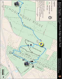
This is an easy walk with well maintained trails. From the parking area first complete the Moler Farm trail through the large fields on the western side of Bakerton Road/WV 27, then combine the Skirmish Line and Upper Loop trails to hike the perimeter of Bolivar Heights.

There are three other hikes in the Harpers Ferry area: School House Ridge, Loudoun Heights, Murphy-Chambers Farm, and the Maryland Heights hikes.

Battle of Harpers Ferry - September 12-15, 1862

As Robert E. Lee advanced into Maryland with the Army of Northern Virginia, he ordered Thomas Jonathan 'Stonewall' Jackson to capture the garrison at Harpers Ferry to secure a supply line back to Virginia. Jackson's troops located on School House Ridge were under the command of A.P. Hill, Lawton, and J.R. Jones. McLaws commanded on Maryland Heights, and Walker and Crutchfield on Loudoun Heights. The first day of fighting saw heavy cannon fire but not advancement by the Confederate forces on Harpers Ferry. To press the battle after a second day of fighting Jackson ordered A.P. Hill to flank Miles's Union troops to the south of their location on Bolivar Heights. That night A.P. Hill moved into position next to the Shenandoah River with 3,500 troops and 20 cannon.

After heavy bombardment on the third day by the Confederate troops Union Col. Dixon S. Miles realized the fight was hopeless and surrendered to Jackson's forces, but died of wounds from Cannon fire before the surrender took affect. Although by Civil War standards the loss of life was considerably fewer, with 44 Union troops and 39 Confederate troops killed, the battle saw the largest surrender of Union troops in one engagement with 12,000 becoming prisoners of war.

Some of the highlights on this hike include:

  • Moler Farm Trail - Split rail fence and fields

  • Confederate Cannon Line - General Stonewall Jackson's cannon line on Schoolhouse Ridge

  • Union Cannon Line - Cononel Dixon Miles' cannon line on Bolivar Heights

  • Bolivar and Harpers Ferry - East towards Bolivar and Harpers Ferry with the Potomac River
Explore 32 trails near Bolivar, WV

Know Before You Go

  • The Bolivar Heights hike (3.3 miles) in Bolivar, WV, offers an easy walk through historically significant Civil War battlegrounds.
  • Bolivar Heights was the site of multiple Civil War battles, including the first at Harpers Ferry and a key engagement during Jackson's Valley Campaign.
  • The hike includes notable landmarks such as the Moler Farm Trail, Confederate cannon line on Schoolhouse Ridge, and Union cannon line on Bolivar Heights, providing insight into the Battle of Harpers Ferry.
Interactive topographic map for Bolivar Heights Hike located in Bolivar, WV. Click the "View Map" button to load GPS coordinates and trail markers.
Get directions
Distance
3.3 mi
Difficulty
Easy
Type
Loop
Est. Time
1.7 hrs
Elev. Gain
375'
Rating
0.0
Added
March 20, 2025
Updated
April 06, 2025

Weather Forecast

Tonight
Low 41°F
Mostly Cloudy
Wednesday
High 48°F
Light Rain Likely
Wednesday Night
Low 22°F
Rain And Snow Likely
Thursday
High 27°F
Slight Chance Light Snow then Mostly Sunny
Thursday Night
Low 16°F
Mostly Clear
Friday
High 33°F
Mostly Sunny
Friday Night
Low 25°F
Partly Cloudy
Saturday
High 41°F
Mostly Sunny then Slight Chance Light Snow
Saturday Night
Low 21°F
Slight Chance Light Snow then Mostly Cloudy
Sunday
High 28°F
Mostly Sunny
Sunday Night
Low 16°F
Partly Cloudy
M.L. King Jr. Day
High 31°F
Mostly Sunny
Monday Night
Low 15°F
Partly Cloudy
Tuesday
High 25°F
Mostly Sunny
Loading...
Total Change
259'
Ascent
375'
Descent
378'
Loading...

Download the GPX Data for Offline Use

Supporters get exclusive access to download trail routes to the MyHikes app for offline use. Stay prepared on your adventure, even without an internet connection! Become a Supporter today to unlock this feature and hike with confidence.

Download Bolivar Heights Hike GPX Data to the MyHikes Mobile App

Features

Vista / Lookout Point
Dogs

Points of interest

  1. Parking

    39.325622, -77.766797
  2. Main Trailhead

    39.325622, -77.766797

Safety information

For your own safety: plan ahead, let someone know where you'll be, and hike at your own risk.

Hazards

Poison Ivy or Poison Oak

Availability

All seasons

Surface type

Dirt

Trip Reports (Reviews)

Your opinion matters! Be the first to rate this trail.

Ready to help fellow hikers? Add a trip report to share your experience and provide valuable insights for other hikers!

No community routes found. To add your own hike as a Community Route for this Trail guide, leave a Trip Report with an attached GPX file.

Popular categories

Scenic mountain view representing vista trails
Vista trails
Scenic gorge of cascades representing waterfall trails
Waterfall hikes
Rugged mountain terrain representing summit trails
Summit trails
Scenic mountain view representing dog-friendly trails
Dog-friendly
Scenic campsite with a view representing camping trails
Camping trails
Appalachian Trail logo representing A.T. hikes
A.T. hikes

You May Also Like

Colorado's Million Dollar Highway - Plan a day's drive adventure along the iconic Million Dollar Highway in Colorado. Explore the best short trails, roadside stops, waterfalls, vistas, ghost towns, and hot springs within a ~6 hour road trip.
Explore

Colorado's Million Dollar Highway

Plan a day's drive adventure along the iconic Million Dollar Highway in Colorado. Explore the best short trails, roadside stops, waterfalls, vistas, ghost towns, and hot springs within a ~6 hour road trip.

Read
🍪 We use cookies to learn about site usage and to serve map tiles. You may block cookies manually in the browser. By continuing you agree. Learn more