The Blue Run Rocks Hiking Trail at Tioga State Forest in Gaines, Pennsylvania is a moderate 3.5 to 3.8-mile out-and-back trail that leads to the massive rocks (glacial deposits) Blue Run Rocks and a large seasonal waterfall, Blue Run Falls. By skipping Blue Run Falls and only visiting Blue Run Rocks, this hike is 3.5-miles out-and-back.
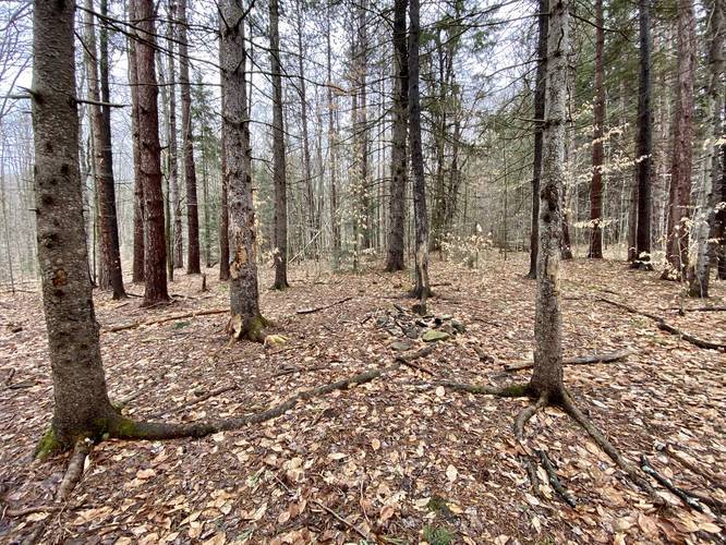
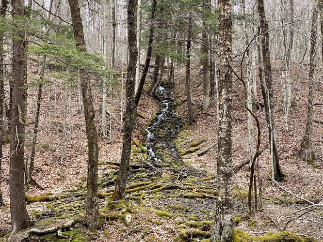
The trail first starts out by following a conifer grove, planted by the Y.C.C in 1978, and then gradually starts heading downhill. Hikers will reach a branch of Blue Run creek about 0.3-miles into the hike where the trail follows the creek until approximately 1.45-miles into the trail.
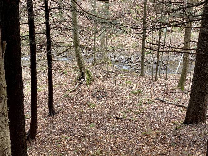
For the first 1.45-miles, the trail heads downhill following red blazes. Once you hike past a creek crossing, with a very small waterfall (about 2-feet tall), you're only about 0.2-miles from the trail junction that leads up to Blue Run Rocks.
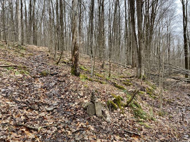
At the trail junction for Blue Run Rocks, the red blazes indicate a left-hand turn and hikers will also find a rock cairn placed at the intersection. The hike up the Blue Run Rocks is not easy and in some places the elevation grade is fairly steep. Hiking uphill toward Blue Run Rocks will get your heart pumping, but the distance is only about 0.4-miles of climbing before the trail finally levels out.
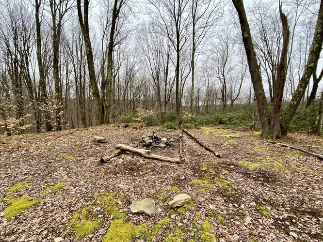
Before the trail truly levels out, hikers will reach yet another trail junction - this trail junction is the loop-portion of the hike that leads uphill and past Blue Run Rocks. This recording stays left at the fork, continuing up the steep hill. At the top of the steep hill are rhododendron bushes that line the trail. Additionally, backpackers will find a couple of campsites along this loop as well, at the top of Blue Run Rocks.
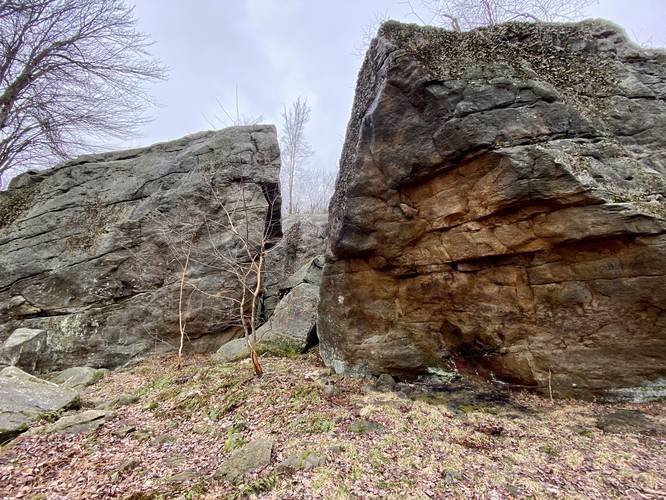
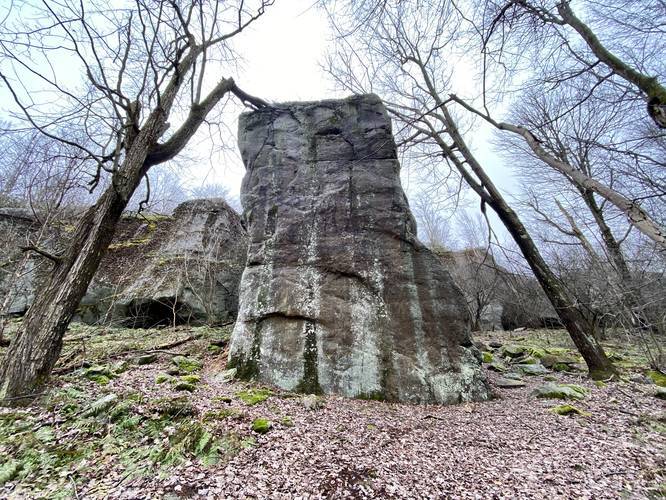
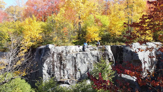
Blue Run Rocks can finally be reached by hiking to the southwest corner of the loop. Blue Run Rocks are a series of massive glacial deposit boulders that form crevases, some small caves, and neat paths to hike between. The trail continues alongside Blue Run Rocks before completing the loop.
Last, before hiking back to parking, hikers should stop at Blue Run Falls - a 50 to 60-foot waterfall that cascades down the creek near the first trail junction that lead off to Blue Run Rocks. Hike back down the mountain from Blue Run Rocks and at the junction, take a left-hand turn. Hike for about 200-feet before taking a sharp right-hand turn that leads down to Blue Run. Once at Blue Run, look across the creek to find the beautiful Blue Run Falls waterfall cascading down the mountainside. During colder months, hikers will get a better view of the entire falls from the trail since the elevation of the main trail is higher up and thus gives a better (obstructed) view of the whole waterfall.
After visiting both Blue Run Rocks and the Blue Run Falls waterfall the hike back to parking is the same as the hike in; however, the elevation grade is mostly all gradual uphill.
Most experienced will find this trail moderate, but the below-average hiker may find this to be a difficult hike.
Blue Run Rocks Bouldering and Rock Climbing
The main destination of this hike is Blue Run Rocks which are massive 20 to 35-foot tall glacial deposit boulders and cliff edge that were left over from the last ice age. These huge boulders give hikers a chance to explore paths that wind between them. The Blue Run Rocks are also used as a popular bouldering destination for boulder climbers and rock climbers.
Waterfall
Hikers will find Blue Run Falls at the bottom of the hill where this trail turns uphill to head up toward Blue Run Rocks. The waterfall is about 50 to 60-feet tall, but the view of the upper falls can only be seen during colder months when no leaves are on the trees. Hiking to the base of the falls gives hikers a view of the lower half of the waterfall, which is about 25 to 30-feet tall. The waterfall cascades down the mountain and is not a free-fall waterfall, but is still beautiful nonetheless.
Camping
There are several campsites along this trail, including one campsite behind Blue Run Rocks right along the trail. Backpackers can use the creeks to filter water.
History
This trail was built by the Y.C.C (U.S. Youth Conservation Corps) in 1978.
Parking
Hikers will find parking along the side of the road near the coordinates provided. There is no parking lot for this trail, but there's enough room to pull off of the road.
Pets
Dogs are allowed if leashed.
The trail first starts out by following a conifer grove, planted by the Y.C.C in 1978, and then gradually starts heading downhill. Hikers will reach a branch of Blue Run creek about 0.3-miles into the hike where the trail follows the creek until approximately 1.45-miles into the trail.
For the first 1.45-miles, the trail heads downhill following red blazes. Once you hike past a creek crossing, with a very small waterfall (about 2-feet tall), you're only about 0.2-miles from the trail junction that leads up to Blue Run Rocks.
At the trail junction for Blue Run Rocks, the red blazes indicate a left-hand turn and hikers will also find a rock cairn placed at the intersection. The hike up the Blue Run Rocks is not easy and in some places the elevation grade is fairly steep. Hiking uphill toward Blue Run Rocks will get your heart pumping, but the distance is only about 0.4-miles of climbing before the trail finally levels out.
Before the trail truly levels out, hikers will reach yet another trail junction - this trail junction is the loop-portion of the hike that leads uphill and past Blue Run Rocks. This recording stays left at the fork, continuing up the steep hill. At the top of the steep hill are rhododendron bushes that line the trail. Additionally, backpackers will find a couple of campsites along this loop as well, at the top of Blue Run Rocks.
Blue Run Rocks can finally be reached by hiking to the southwest corner of the loop. Blue Run Rocks are a series of massive glacial deposit boulders that form crevases, some small caves, and neat paths to hike between. The trail continues alongside Blue Run Rocks before completing the loop.
Last, before hiking back to parking, hikers should stop at Blue Run Falls - a 50 to 60-foot waterfall that cascades down the creek near the first trail junction that lead off to Blue Run Rocks. Hike back down the mountain from Blue Run Rocks and at the junction, take a left-hand turn. Hike for about 200-feet before taking a sharp right-hand turn that leads down to Blue Run. Once at Blue Run, look across the creek to find the beautiful Blue Run Falls waterfall cascading down the mountainside. During colder months, hikers will get a better view of the entire falls from the trail since the elevation of the main trail is higher up and thus gives a better (obstructed) view of the whole waterfall.
After visiting both Blue Run Rocks and the Blue Run Falls waterfall the hike back to parking is the same as the hike in; however, the elevation grade is mostly all gradual uphill.
Most experienced will find this trail moderate, but the below-average hiker may find this to be a difficult hike.
Blue Run Rocks Bouldering and Rock Climbing
The main destination of this hike is Blue Run Rocks which are massive 20 to 35-foot tall glacial deposit boulders and cliff edge that were left over from the last ice age. These huge boulders give hikers a chance to explore paths that wind between them. The Blue Run Rocks are also used as a popular bouldering destination for boulder climbers and rock climbers.
Waterfall
Hikers will find Blue Run Falls at the bottom of the hill where this trail turns uphill to head up toward Blue Run Rocks. The waterfall is about 50 to 60-feet tall, but the view of the upper falls can only be seen during colder months when no leaves are on the trees. Hiking to the base of the falls gives hikers a view of the lower half of the waterfall, which is about 25 to 30-feet tall. The waterfall cascades down the mountain and is not a free-fall waterfall, but is still beautiful nonetheless.
Camping
There are several campsites along this trail, including one campsite behind Blue Run Rocks right along the trail. Backpackers can use the creeks to filter water.
History
This trail was built by the Y.C.C (U.S. Youth Conservation Corps) in 1978.
Parking
Hikers will find parking along the side of the road near the coordinates provided. There is no parking lot for this trail, but there's enough room to pull off of the road.
Pets
Dogs are allowed if leashed.