Loading...

WINTER SALE! 50% OFF Supporter Accounts — now through January 31st. Learn More.

Blackwater Falls

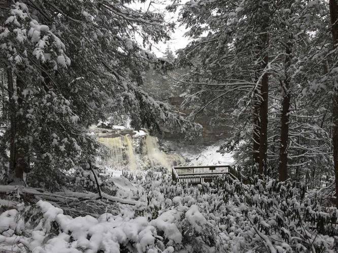
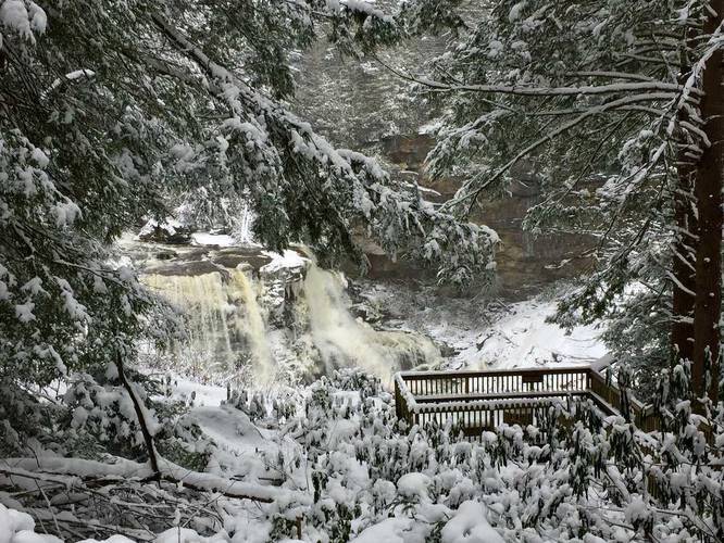
The Blackwater Falls Trail at Blackwater Falls State Park in Davis, West Virginia is an easy 0.2 mile out-and-back hike that leads down to viewing platforms next to Blackwater Falls.

This trail starts at the Blackwater Falls trading post parking lot and heads down a series of stairs and gravel trail to reach the falls. During warmer months, the trail leads all the way to the base of the falls to a large lookout platform; however, In the winter, the staircase down to the falls is blocked off as the park does not want to risk visitors getting too close to the falls when there aren't many people around - you can still get a great view of Blackwater Falls though.

This is one of the most highly-trafficked trails at the park.

Note: If you would like to view Blackwater Falls and need a more accessible trail, check out the Gentle Trail across the river. It's wheelchair accessible and a similar length.
Explore 50 trails near Davis, WV

Know Before You Go

  • Blackwater Falls Trail is an easy, popular 0.2-mile hike in Blackwater Falls State Park, Davis, WV, leading to viewing platforms of Blackwater Falls.
  • The trail is mostly stairs and gravel, with access to the base of the falls during warmer months, but the lower section is closed in winter for safety.
  • An alternative, wheelchair-accessible trail called the Gentle Trail is available across the river for those needing an easier route to view the falls.
Interactive topographic map for Blackwater Falls located in Davis, WV. Click the "View Map" button to load GPS coordinates and trail markers.
Get directions
Distance
0.1 mi
Difficulty
Easy
Type
Out-and-Back
Est. Time
5 min
Elev. Gain
82'
Rating
0.0
Added
March 11, 2018
Updated
September 09, 2018

Weather Forecast

Loading...
Total Change
75'
Ascent
82'
Descent
82'
Loading...

Download the GPX Data for Offline Use

Supporters get exclusive access to download trail routes to the MyHikes app for offline use. Stay prepared on your adventure, even without an internet connection! Become a Supporter today to unlock this feature and hike with confidence.

Download Blackwater Falls GPX Data to the MyHikes Mobile App

Features

Vista / Lookout Point
Dogs
Waterfalls

Points of interest

  1. Parking

    39.112539, -79.483883
  2. Main Trailhead

    39.112539, -79.483883

Safety information

For your own safety: plan ahead, let someone know where you'll be, and hike at your own risk.

Availability

All seasons

Surface type

Dirt

Trip Reports (Reviews)

Your opinion matters! Be the first to rate this trail.

Ready to help fellow hikers? Add a trip report to share your experience and provide valuable insights for other hikers!

0.1 miles / 0.2 km
March 10, 2018
Hiking
No community routes found. To add your own hike as a Community Route for this Trail guide, leave a Trip Report with an attached GPX file.

Popular categories

Scenic mountain view representing vista trails
Vista trails
Scenic gorge of cascades representing waterfall trails
Waterfall hikes
Rugged mountain terrain representing summit trails
Summit trails
Scenic mountain view representing dog-friendly trails
Dog-friendly
Scenic campsite with a view representing camping trails
Camping trails
Appalachian Trail logo representing A.T. hikes
A.T. hikes

You May Also Like

Colorado's Million Dollar Highway - Plan a day's drive adventure along the iconic Million Dollar Highway in Colorado. Explore the best short trails, roadside stops, waterfalls, vistas, ghost towns, and hot springs within a ~6 hour road trip.
Explore

Colorado's Million Dollar Highway

Plan a day's drive adventure along the iconic Million Dollar Highway in Colorado. Explore the best short trails, roadside stops, waterfalls, vistas, ghost towns, and hot springs within a ~6 hour road trip.

Read
🍪 We use cookies to learn about site usage and to serve map tiles. You may block cookies manually in the browser. By continuing you agree. Learn more