Loading...

WINTER SALE! 50% OFF Supporter Accounts — now through January 31st. Learn More.

Birkhead Mountain Wilderness Hike

The Birkhead Mountains Wilderness and the surrounding Uwharrie National Forest sure feels like a lonely place considering it is within 90 minutes of the 3 largest metropolitan areas in North Carolina. With only 50,645 acres of land Uwharrie is by far the smallest of the four national forests in the state, but it boasts a wealth of mixed-used trails on the east side of the Uwharrie Lakes region. The Birkhead Mountains Wilderness is on the far northern tip of this national forest, and at 5,160 acres can be easily explored in a day or a weekend. You won’t get long-distance views here, or a wealth of mountainous streams. The Uwharrie Mountains barely qualify as mountains. They are thought to be the oldest mountain range on the North American continent, and millions of years of erosion has whittled these peaks to elevations typically between 600-1,100 feet.  

Although you won’t get a true mountain experience, the Birkhead Mountains Wilderness provides an excellent system of trails perfect for day hiking and trail running. Three trails make a loop in the center of this wilderness, with four spokes providing different trail access points. This central hub allows you to choose the length of your hike, from 7.2 miles to the 12.0-mile hike described here. The relative ease of these trails makes it the perfect laboratory for testing out gear for longer trips, or for introducing friends and family to backpacking. There are many superb campsites sprinkled throughout the wilderness which provide solitude and an enjoyable night out a short distance away from the state’s largest cities.

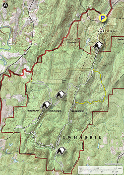
Trail Access – The hike described here starts at the Tot Hill Farm Access at the northern terminus of the Birkhead Mountain Trail [100]. The two access areas on the west side of the wilderness are the Thornburg Connector Trail [394] and Robbins Branch Trail [393]. The southern terminus of the Birkhead Mountain Trail [100] can be reached via Strieby Church Road [SR 1114]. All trails in the wilderness are blazed white and all major intersections have signs. Paper maps are typically available at the trailheads. Some trails to campsites are blazed yellow when they are a significant distance off the main trails.


  • Mile 0.0 – Park at the Tot Hill Farm Access for the Birkhead Mountain Trail [100] (white blaze). The trail immediately turns left to hop over Talbotts Branch.
  • Mile 0.1 – Trail Y-splits when it meets Talbotts Branch, turn left.
  • Mile 0.2 – Wooden bridge over Talbotts Branch. Before the bridge is a campsite on the left.
  • Mile 0.6 – Y-split with unmarked trail, continue right.
  • Mile 0.9 – T-junction with a forest road grade, turn left. In 150 feet the trail turns right leaving the forest road.
  • Mile 1.2 – At the summit of Coolers Knob Mountain there are excellent campsites on both sides of the trail.
  • Mile 1.8 – Y-junction with the Camp Three Trail (yellow blaze). The sign indicates Camp 3 is 1.2 miles from this junction, a secluded backcountry campsite along North Prong Hannahs Creek with historic mine remnants.
  • Mile 2.0 – Campsite on the right side of the trail.
  • Mile 2.6 – T-junction with the Robbins Branch Trail [393] (white blaze). Stay left to continue south on the Birkhead Mountain Trail, or you can reverse this loop and turn right on the Robbins Branch Trail. There is an excellent campsite 0.8-mi from the intersection beside Robbins Branch if you are backpacking.
  • Mile 2.9 – Campsite on the right side of the trail.
  • Mile 3.0 – T-junction with the Camp Three Trail (yellow blaze). Large campsite with a wooden sign Camp 5 on the right side of the trail.
  • Mile 4.4 – Campsite on the right side of the trail.
  • Mile 4.6 – T-junction with the Hannahs Creek Trail (white blaze). Continue straight on the Birkhead Mountain Trail for an optional trip to the Bingham Graveyard.
  • Mile 4.7 – Y-split, the Birkhead Mountain Trail turns right while a yellow-blazed trail continues left to a campsite and the graveyard. Immediately you’ll encounter another Y-split, turn left.
  • Mile 4.8 – Large campsite on the left side of the trail. Beyond the campsite the trail splits again. On the right split is the Christopher Bingham Graveyard. There are small headstones on each side of the path.
  • Mile 4.9 - The side path on the left side is slightly overgrown but leads down to access North Prong Hannahs Creek. Turn around and head back to the Hannahs Creek Trail junction.
  • Mile 5.1 – Turn left on Hannahs Creek Trail.
  • Mile 5.3 – Cross a tiny tributary to Hannahs Creek. Immediately past this crossing is a campsite on the right side of the trail. Soon after you’ll see a chimney remnant on the left side of the trail with another campsite.
  • Mile 6.0 – There are multiple campsites on the left side of the trail before you cross Robbins Branch. A few side paths on the left lead to the confluence of Robbins Branch and Hannahs Creek.
  • Mile 6.5 – Boulder field on the right side of trail. There are campsites intermingled on both sides of the trail in this area.
  • Mile 6.7 – Y-junction with the Robbins Branch Trail [393] (white blaze), turn right to begin the Robbins Branch Trail. A left here would lead to the Robbins Branch Access.
  • Mile 7.9 – Huge campsite area on the right side of the trail.
  • Mile 8.0 – T-junction with the Thornburg Connector Trail [394] (white blaze). Turn right to continue following the Robbins Branch Trail. The Thornburg Connector Trail leads to the Thornburg Farm Access parking area.
  • Mile 8.3 – Robbins Branch Trail crosses Robbins Branch.
  • Mile 8.4 – Second crossing over Robbins Branch.
  • Mile 8.5 – Third crossing over Robbins Branch.
  • Mile 8.55 – Fourth crossing over Robbins Branch.
  • Mile 8.7 – Large campsite beside the trickling Robbins Branch. On the left side uphill from this campsite are impressively tall hardwoods.
  • Mile 9.5 – Robbins Branch Trail ends at a T-junction with the Birkhead Mountain Trail. Turn left to head back to the parking area.
  • Mile 11.3 – Hike ends at the Tot Hill Farm Access.
By HikingUpward Contributor: Zach Robbins
Explore 2 trails near Asheboro, NC

Know Before You Go

  • Birkhead Mountain Wilderness offers accessible hiking and trail running opportunities within a compact area, making it suitable for beginners and gear testing.
  • The wilderness area features a network of interconnected trails with multiple access points, allowing for customizable hike lengths and routes.
  • There are numerous campsites scattered throughout the area, providing opportunities for secluded overnight trips near urban centers.
Interactive topographic map for Birkhead Mountain Wilderness Hike located in Asheboro, NC. Click the "View Map" button to load GPS coordinates and trail markers.
Get directions
Distance
11.3 mi
Difficulty
Moderate
Type
Out-and-Back
Est. Time
5.7 hrs
Elev. Gain
1,491'
Rating
4.0
Added
March 20, 2025
Updated
April 06, 2025

Weather Forecast

Loading...
Total Change
443'
Ascent
1,491'
Descent
1,496'
Loading...

Download the GPX Data for Offline Use

Supporters get exclusive access to download trail routes to the MyHikes app for offline use. Stay prepared on your adventure, even without an internet connection! Become a Supporter today to unlock this feature and hike with confidence.

Download Birkhead Mountain Wilderness Hike GPX Data to the MyHikes Mobile App

Features

Vista / Lookout Point
Dogs
Mountain Summit
Camping
Water Source

Points of interest

  1. Parking

    35.636631, -79.904566
  2. Main Trailhead

    35.636631, -79.904566

Safety information

For your own safety: plan ahead, let someone know where you'll be, and hike at your own risk.

Hazards

Snakes (Rattlesnakes, Copperheads, others)
Poison Ivy or Poison Oak

Markers

Blaze Color

White

Availability

All seasons

Surface type

Dirt

Trip Reports (Reviews)

Rated 4.0 out of 5 based on 1 rating.

Ready to help fellow hikers? Add a trip report to share your experience and provide valuable insights for other hikers!

By: Michael
11.3 miles / 18.2 km
March 23, 2019
I have been taking a BSA Scout troop to Birkhead Wilderness every year since 2016. We have hiked in from Thornburg and also from Tot Hill. Tot Hill parking lot is kind of small so be aware! From Tot Hill we have hiked to Camp 3 which is a really good place. There is an old covered spring down there. We also found several large holes with machinery and girders within-probably left over from mining days. On this day-hike, the weather was clear and sunny all day. Just warm enough for shorts. We came in from Tot Hill farm access in a crew of 8 and we did the hike anti clockwise staying on Birkhead, Robbins, Hannah and Birkhead trails the whole day. The trails are wide enough to travel three in a row in most places. On this day, on many sections there was a lot of mud in the center of the trail due to late winter rains and storms so we mostly were stretched out single file. There was at least 6 to 8 trees down crossing over the trail which required detours most of the time. We stopped for lunch about 11:30 AM (kind of early!) and we practiced back country cooking/cleaning, leave no trace and sump hole disposal of the grey water. We had planned to find the graveyard but time did not allow any side trips. There was lots of water available except for the ridge section of the Birkhead. Most of the trees were still without leaves so there was a feeling of space on this early spring hike. As we traveled the trails, we noticed several different ecological zones ranging from rhododendron groupings, short leaf pine and hardwoods. To hikngupward, thanks for putting this hike on the map. Its a good one as its a great introduction to a wilderness that is really thriving.
Legacy Review
No community routes found. To add your own hike as a Community Route for this Trail guide, leave a Trip Report with an attached GPX file.

Popular categories

Scenic mountain view representing vista trails
Vista trails
Scenic gorge of cascades representing waterfall trails
Waterfall hikes
Rugged mountain terrain representing summit trails
Summit trails
Scenic mountain view representing dog-friendly trails
Dog-friendly
Scenic campsite with a view representing camping trails
Camping trails
Appalachian Trail logo representing A.T. hikes
A.T. hikes

You May Also Like

25 Best Day Hikes in North Carolina - Discover the top 25 best day hikes in North Carolina, from breathtaking waterfalls to mountain peaks. Explore hidden gems, scenic views, and trails suitable for all skill levels, perfect for your next outdoor adventure.
Explore

25 Best Day Hikes in North Carolina

Discover the top 25 best day hikes in North Carolina, from breathtaking waterfalls to mountain peaks. Explore hidden gems, scenic views, and trails suitable for all skill levels, perfect for your next outdoor adventure.

Read
Colorado's Million Dollar Highway - Plan a day's drive adventure along the iconic Million Dollar Highway in Colorado. Explore the best short trails, roadside stops, waterfalls, vistas, ghost towns, and hot springs within a ~6 hour road trip.
Explore

Colorado's Million Dollar Highway

Plan a day's drive adventure along the iconic Million Dollar Highway in Colorado. Explore the best short trails, roadside stops, waterfalls, vistas, ghost towns, and hot springs within a ~6 hour road trip.

Read
Glacier's Going-to-the-Sun Road - Discover the breathtaking beauty of Glacier National Park along the iconic Going-to-the-Sun Road. From stunning roadside stops to picturesque waterfalls and vistas, this engineering marvel offers endless opportunities for exploration.
Explore

Glacier's Going-to-the-Sun Road

Discover the breathtaking beauty of Glacier National Park along the iconic Going-to-the-Sun Road. From stunning roadside stops to picturesque waterfalls and vistas, this engineering marvel offers endless opportunities for exploration.

Read
🍪 We use cookies to learn about site usage and to serve map tiles. You may block cookies manually in the browser. By continuing you agree. Learn more