The Birch Trail to Chimney Rocks at Tioga State Forest near Leetonia, Pennsylvania is a strenuous 4.2-mile loop hike that leads up a rocky mountain spine with 10-foot tall rock spires - referred to as Chimney Rocks - and features a beautiful northwest-facing vista of Cedar Run creek. This trail is also rattlesnake territory and should be considered a safe off-season hike, during cold months, to ensure safety.
Trails
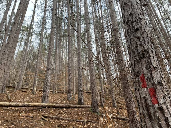
This hike follows one trail - Birch Trail (red blazes) and one public road - Leetonia Road.
Trail Type
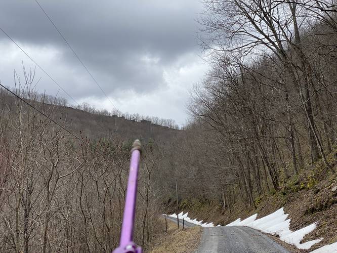
This trail is technically a one-way trail of approximately 2.8-miles; however, without two cars, this becomes a loop hike using Leetonia Road to hike back to parking. The road portion of the hike is approximately 1.4-miles long, making this either a 2.8-mile one-way hike with two cars or a 4.2-mile loop hike with one car. The nice part about the loop is, during colder months, hikers can spot the Chimney Rocks up on the mountain ridge from the road.
Hike Description
This trail has two trailhead locations, but it appears to be easiest to hike this in a loop starting in the south - while using Leetonia Road for your return hike. The reason for this is because of the steep terrain along the mountain spine leading up to Chimney Rocks.
The start of this hike begins at the southern trailhead - just north of Fahnestock Run. The trail immediately heads up a steep mountain hillside through a beautiful pine forest before it reaches an old logging grade. The trail will take a left-hand turn off of the logging grade and head straight up the mountain ridge. The elevation grade from here, until the top of the mountain, should be considered strenuous. Along the way, hikers will begin to find several smaller rock outcroppings before they reach some of the bigger outcroppings of Chimney Rocks.
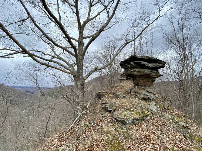
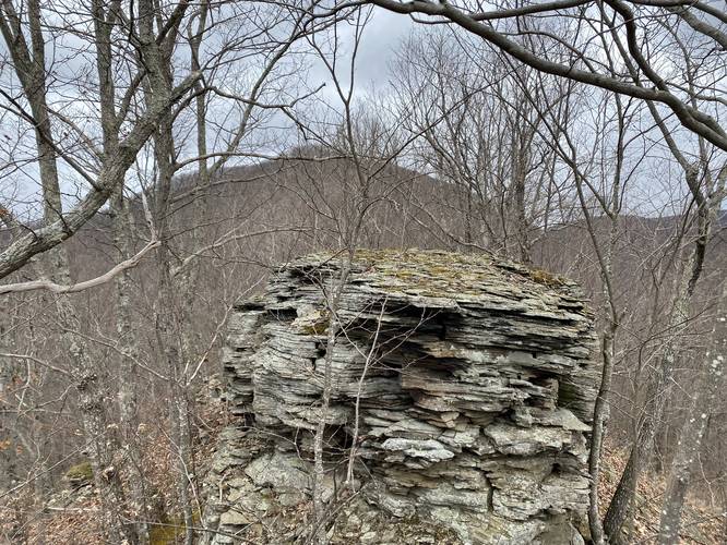
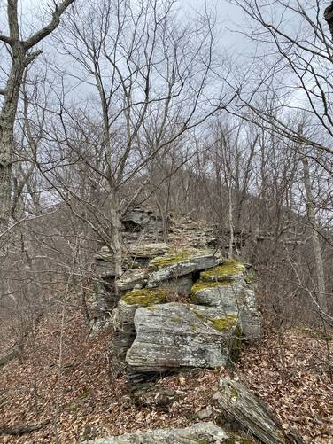
Chimney Rocks and Views - Mile 0.15 to 0.9
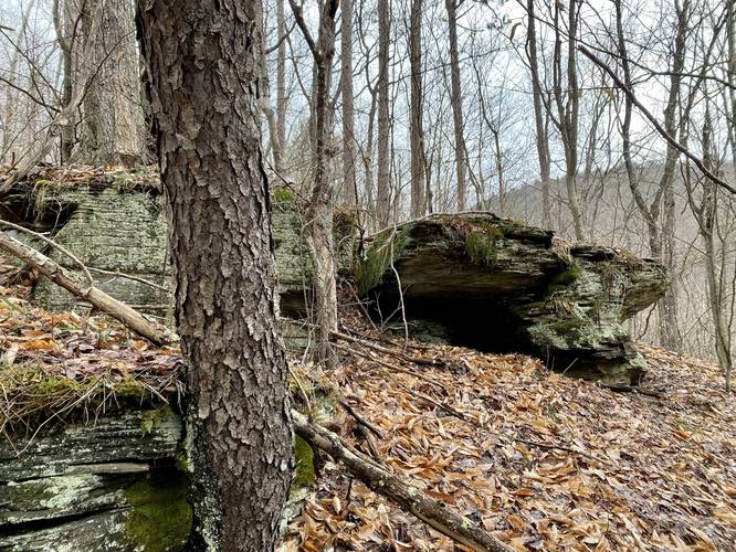
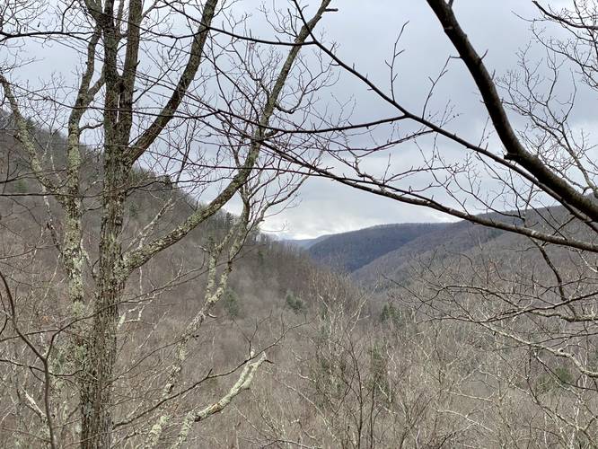
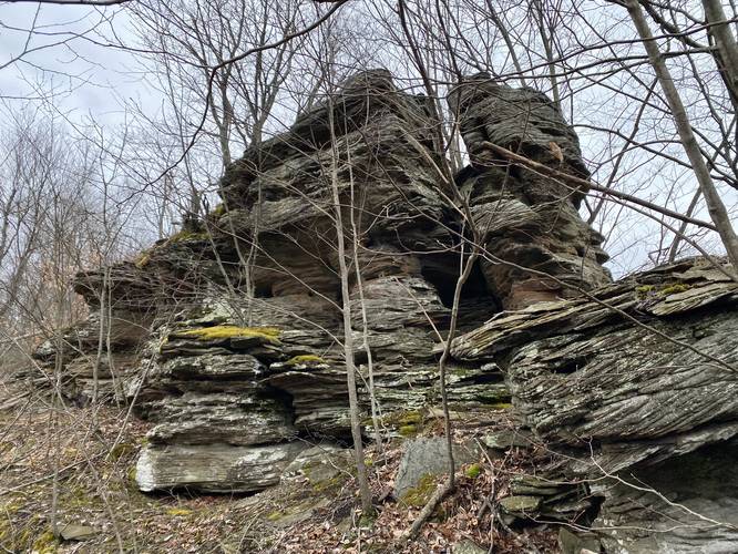
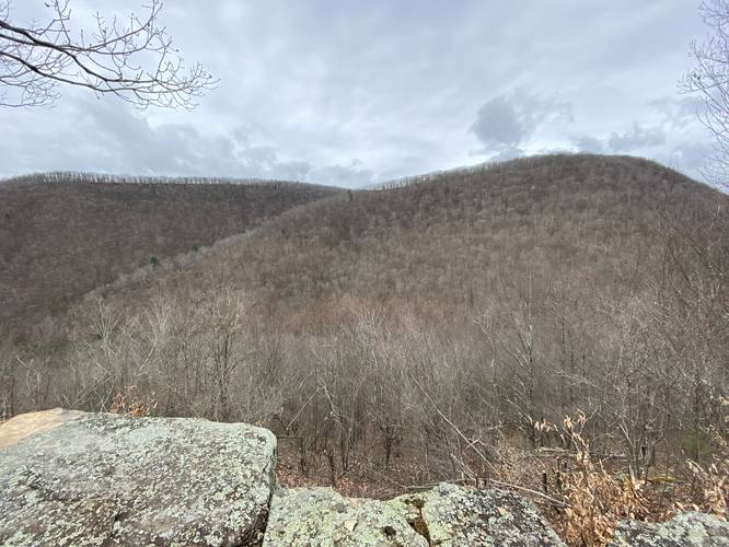
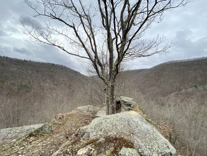
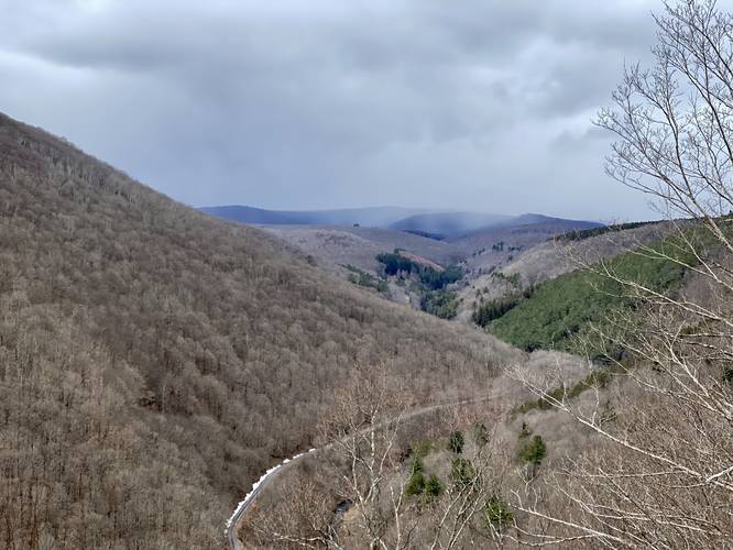
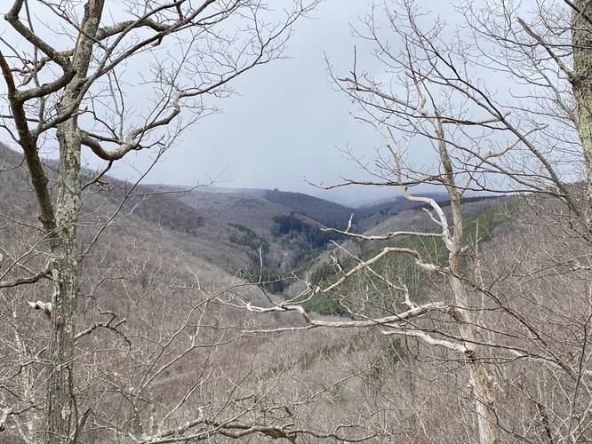
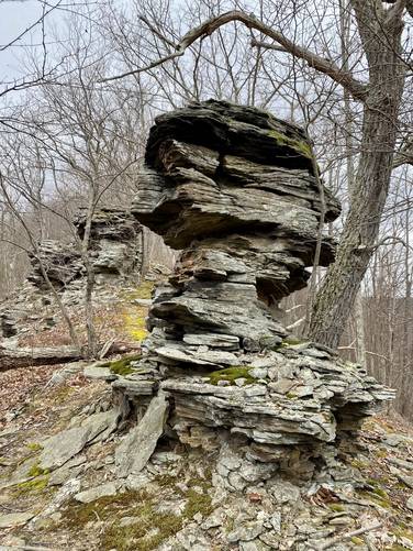
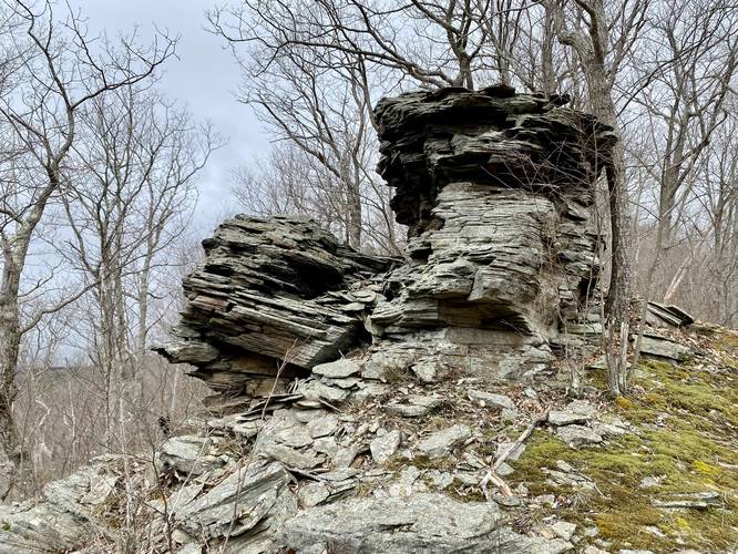
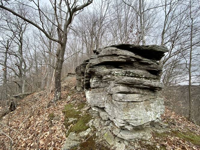
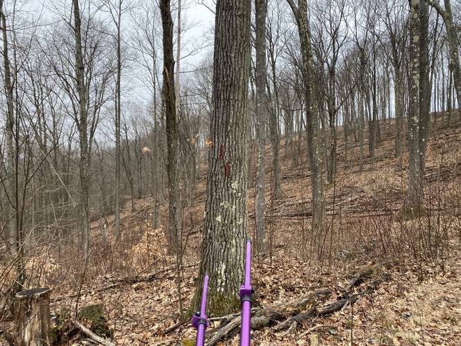
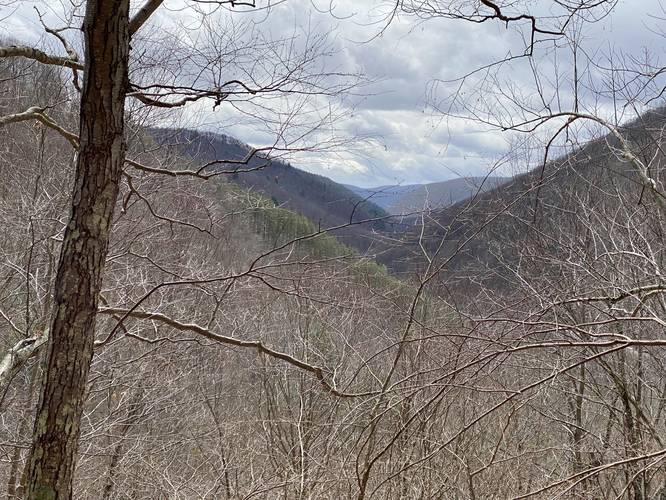
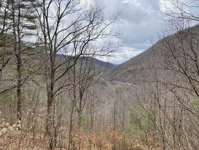
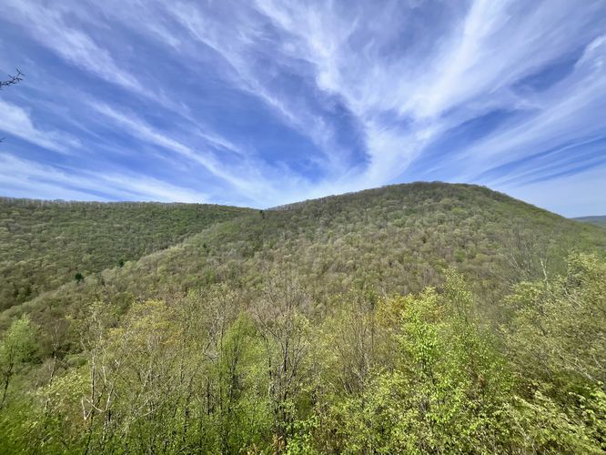
Hikers will note that this trail climbs the mountain ridge passing and climbing rock outcroppings known as Chimney Rocks. These rock outcroppings continue up the mountain ridge for what seems like forever. I (Admin) personally have not seen another mountain ridge in Tioga State Forest with as many outcroppings as this location. Additionally, these outcroppings include views along the way - both south and north views of the mountains that surround Cedar Run, like Gleason Hill. Some views have a "double vista" where you can see in both directions, albeit north is prettier. Some of these Chimney Rocks outcroppings even help form rock slides that prevent vegetation from growing on the mountain - a somewhat rare occurrence for this part of Pennsylvania, since this area's mountains generally do not have natural slides. It's apparent that back in the day, these rocky outcroppings were likely harvested for whatever resources people could get out of them. Today, what's left are rattlesnake habitats, a unique ecosystem of ferns, mosses, and other vegetation, but also views for hikers. Take this section slow, enjoy the views, and watch out for snakes. Views can be found between miles 0.3 and 0.8 while Chimney Rocks can be found between miles 0.15 and 0.9.
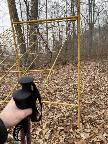
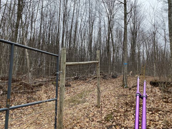
Deer Fence, Thorn Bushes, Service Road - Mile 1.04 to 1.65
After visiting the rocky outcroppings of the mountain ridge, hikers will find a deer fence with a yellow metal gate. Here, head into the fence area via the yellow gate, and prepare for thorn bushes for approximately 0.2-miles. Once out of the thorns, the faded red blazes of the Birch Trail will lead onto a service road. Hike down this service road until you reach the other side of the deer fence. Look to your right-hand side for another yellow gate - go through this gate to reach the other side.
Gleason Hollow Turn - Mile 1.7
Just after the deer fence gate on the north side, hikers will begin to look for red blazes of the Birch Trail that lead down into Gleason Hollow. This section is a bit tricky, but can be easier to follow during colder months when no leaves are on the trees. Either way, look for a double blaze indicating a left-hand turn into Gleason Hollow and pass through more larger thorn bushes to begin your descent into Gleason Hollow. Note that this portion of the hike is a bit annoying to follow since the red blazes that lead down into Gleason Hollow are spread far and thin with faded red blazes, as of early April 2022.
Seasonal Vistas - Mile 2.25 and 2.3
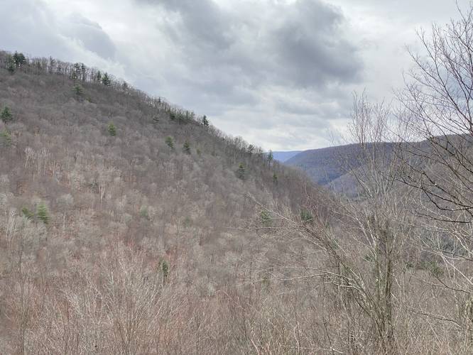
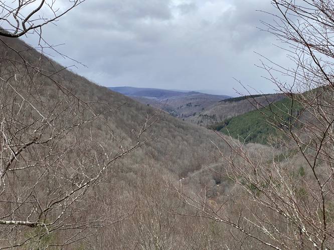
After passing through Gleason Hollow, the Birch Trail will begin to skirt around the side of the mountain before it descends further. Around mile 2.25 and 2.3, just before the trail passes through a pine forest, hikers will find two seasonal vistas facing south which include views of the mountains that surround Cedar Run.
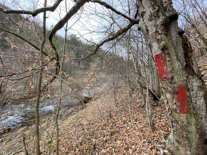
Creek Crossing - Mile 2.6
Hikers will need to cross Cedar Run around mile 2.6, which is not difficult and is approximately knee-deep. In early Spring, the water is generally very cold, so bring trekking poles to ensure proper footing.
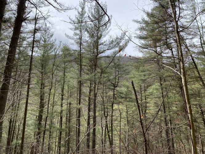
Spruce Forest - Mile 2.65 to 2.8
Just before the trail ends is a unique spruce forest that feels like something out of Oregon or the west coast United States. A lot of the spruce in this forest appeared dead as of April 2022, but at least half appeared to be alive, with moss, ferns, and other green vegetation growing on the forest floor. This section of the trail should be enjoyed by day hikers looking for a quick unique stop as well since it's right near the northern trailhead.
Hiking Back
At mile 2.8, hikers will reach the northern trailhead terminus for the Birch Trail. This is where a solo hiker will begin their loop hike back to parking by following Leetonia Road for approximately 1.4-miles one-way. During cold months, hikers can see Chimney Rocks from the road, along with the tops of some beautiful pine forests. Note that the road is extremely steep off to one side, so be careful with traffic.
Warnings
Rattlesnakes: This trail leads up and into Timber Rattlesnake habitats (the rocky outcroppings). Between late April and early October, rattlesnakes can be found sunning themselves on rocky outcroppings in and around this area.
Steep terrain: This trail follows some really steep terrain in certain areas. It's best to consider bringing trekking poles to aid in the hike.
Thorn bushes: One the mountain top, hikers must wade their way through a long stretch of thorn bushes. Be prepared and bring the proper clothing to aid in this.
Creek crossing: At the northern end of this trail, hikers must cross Cedar Run creek in order to follow the trail. Note that when planning this hike so that you get your feet wet near the end instead of the beginning of the trek.
Parking
Hikers will find two parking lots for this trail. The southern parking lot is the closest parking to Chimney Rocks, hence the most popular, but only holds about two vehicles. The northern parking lot can hold about 2 vehicles as well.
Pets
Dogs are allowed if leashed and their waste should be carried out. Please note that dogs should really only be on this trail during cold months to reduce running into a rattlesnake, if they're brought on the trail at all. Also note that because of the creek crossing, it might not be best to bring a smaller dog. Or just leave your dog at home.
Camping and Backpacking
While there are no campsite areas along this trail, dispersed / primitive / backcountry camping is allowed in Tioga State Forest. Please follow all rules and regulations when doing so.
Trails
This hike follows one trail - Birch Trail (red blazes) and one public road - Leetonia Road.
Trail Type
This trail is technically a one-way trail of approximately 2.8-miles; however, without two cars, this becomes a loop hike using Leetonia Road to hike back to parking. The road portion of the hike is approximately 1.4-miles long, making this either a 2.8-mile one-way hike with two cars or a 4.2-mile loop hike with one car. The nice part about the loop is, during colder months, hikers can spot the Chimney Rocks up on the mountain ridge from the road.
Hike Description
This trail has two trailhead locations, but it appears to be easiest to hike this in a loop starting in the south - while using Leetonia Road for your return hike. The reason for this is because of the steep terrain along the mountain spine leading up to Chimney Rocks.
The start of this hike begins at the southern trailhead - just north of Fahnestock Run. The trail immediately heads up a steep mountain hillside through a beautiful pine forest before it reaches an old logging grade. The trail will take a left-hand turn off of the logging grade and head straight up the mountain ridge. The elevation grade from here, until the top of the mountain, should be considered strenuous. Along the way, hikers will begin to find several smaller rock outcroppings before they reach some of the bigger outcroppings of Chimney Rocks.
Chimney Rocks and Views - Mile 0.15 to 0.9
Hikers will note that this trail climbs the mountain ridge passing and climbing rock outcroppings known as Chimney Rocks. These rock outcroppings continue up the mountain ridge for what seems like forever. I (Admin) personally have not seen another mountain ridge in Tioga State Forest with as many outcroppings as this location. Additionally, these outcroppings include views along the way - both south and north views of the mountains that surround Cedar Run, like Gleason Hill. Some views have a "double vista" where you can see in both directions, albeit north is prettier. Some of these Chimney Rocks outcroppings even help form rock slides that prevent vegetation from growing on the mountain - a somewhat rare occurrence for this part of Pennsylvania, since this area's mountains generally do not have natural slides. It's apparent that back in the day, these rocky outcroppings were likely harvested for whatever resources people could get out of them. Today, what's left are rattlesnake habitats, a unique ecosystem of ferns, mosses, and other vegetation, but also views for hikers. Take this section slow, enjoy the views, and watch out for snakes. Views can be found between miles 0.3 and 0.8 while Chimney Rocks can be found between miles 0.15 and 0.9.
Deer Fence, Thorn Bushes, Service Road - Mile 1.04 to 1.65
After visiting the rocky outcroppings of the mountain ridge, hikers will find a deer fence with a yellow metal gate. Here, head into the fence area via the yellow gate, and prepare for thorn bushes for approximately 0.2-miles. Once out of the thorns, the faded red blazes of the Birch Trail will lead onto a service road. Hike down this service road until you reach the other side of the deer fence. Look to your right-hand side for another yellow gate - go through this gate to reach the other side.
Gleason Hollow Turn - Mile 1.7
Just after the deer fence gate on the north side, hikers will begin to look for red blazes of the Birch Trail that lead down into Gleason Hollow. This section is a bit tricky, but can be easier to follow during colder months when no leaves are on the trees. Either way, look for a double blaze indicating a left-hand turn into Gleason Hollow and pass through more larger thorn bushes to begin your descent into Gleason Hollow. Note that this portion of the hike is a bit annoying to follow since the red blazes that lead down into Gleason Hollow are spread far and thin with faded red blazes, as of early April 2022.
Seasonal Vistas - Mile 2.25 and 2.3
After passing through Gleason Hollow, the Birch Trail will begin to skirt around the side of the mountain before it descends further. Around mile 2.25 and 2.3, just before the trail passes through a pine forest, hikers will find two seasonal vistas facing south which include views of the mountains that surround Cedar Run.
Creek Crossing - Mile 2.6
Hikers will need to cross Cedar Run around mile 2.6, which is not difficult and is approximately knee-deep. In early Spring, the water is generally very cold, so bring trekking poles to ensure proper footing.
Spruce Forest - Mile 2.65 to 2.8
Just before the trail ends is a unique spruce forest that feels like something out of Oregon or the west coast United States. A lot of the spruce in this forest appeared dead as of April 2022, but at least half appeared to be alive, with moss, ferns, and other green vegetation growing on the forest floor. This section of the trail should be enjoyed by day hikers looking for a quick unique stop as well since it's right near the northern trailhead.
Hiking Back
At mile 2.8, hikers will reach the northern trailhead terminus for the Birch Trail. This is where a solo hiker will begin their loop hike back to parking by following Leetonia Road for approximately 1.4-miles one-way. During cold months, hikers can see Chimney Rocks from the road, along with the tops of some beautiful pine forests. Note that the road is extremely steep off to one side, so be careful with traffic.
Warnings
Rattlesnakes: This trail leads up and into Timber Rattlesnake habitats (the rocky outcroppings). Between late April and early October, rattlesnakes can be found sunning themselves on rocky outcroppings in and around this area.
Steep terrain: This trail follows some really steep terrain in certain areas. It's best to consider bringing trekking poles to aid in the hike.
Thorn bushes: One the mountain top, hikers must wade their way through a long stretch of thorn bushes. Be prepared and bring the proper clothing to aid in this.
Creek crossing: At the northern end of this trail, hikers must cross Cedar Run creek in order to follow the trail. Note that when planning this hike so that you get your feet wet near the end instead of the beginning of the trek.
Parking
Hikers will find two parking lots for this trail. The southern parking lot is the closest parking to Chimney Rocks, hence the most popular, but only holds about two vehicles. The northern parking lot can hold about 2 vehicles as well.
Pets
Dogs are allowed if leashed and their waste should be carried out. Please note that dogs should really only be on this trail during cold months to reduce running into a rattlesnake, if they're brought on the trail at all. Also note that because of the creek crossing, it might not be best to bring a smaller dog. Or just leave your dog at home.
Camping and Backpacking
While there are no campsite areas along this trail, dispersed / primitive / backcountry camping is allowed in Tioga State Forest. Please follow all rules and regulations when doing so.