Loading...

🎉 Enjoy a Free 7-Day Supporter Trial and Unlock Exclusive Perks — No Credit Card Required. Learn more.

Bill Kruszka Overlook Hike

Directions
Map
Pictures
Send to App
Distance:
4.8 Miles / 7.7 km
Type:
Out-and-Back
Difficulty:
Moderate
Time to Hike:
2 hours, ~24 minutes
Features:
Surface Type:
Dirt
Park:
George Washington National Forest
Town:
Edinburg, Virginia
Directions:
38.789213, -78.520408
Added:
January 24, 2025
Updated:
April 04, 2025
Copy Trail Link Hiking this trail? Send a friend or family member a link to this trail guide for your own safety. Hike at your own risk (disclaimer)
Loading...
Loading...
990'

Total Change
1,480'

Ascent
1,480'

Descent

Download the Trail Route for Offline Use

Supporters get exclusive access to download trail routes to the MyHikes app for offline use. Stay prepared on your adventure, even without an internet connection! Become a Supporter today to unlock this feature and hike with confidence.

Send to App

Bill Kruszka Overlook Hike

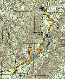
One of the least visited overlooks in the Massanutten Range and northwestern Virginia. The Bill Kruszka Overlook is named for the longtime Forestry Service employee who was instrumental, along with Don Sawyer, in developing many of the trails in the Lee Ranger District. The overlook is a rocky outcrop with sweeping views of Short Mountain and Edinburg in the Shenandoah Valley. The Massanutten Trail crosses Edinburg Gap just south of Waonaze Peak on the western ridge of the Massanutten Range.

This hike has several views of Fort Valley through the trees as it climbs the mountain, as well as passing a spring at 1.1 miles. You are unlikely to run into other people on this hike, however the ATV trails in the forest are close so don't be surprised if you hear them. This area of the Massanutten also has a high concentration of Timber Rattlesnakes, so in the warmer months keep an eye on the trail as these forest residents are well camouflaged and can be hard to spot.

A great way to spend the day is to hike up to the overlook, then afterwards head into Woodstock to the family friendly Woodstock Brewery that servers great beer, homemade root bear, and very good food.

  • Mile 0.0 - From the parking area on FS 374 walk back to Edinburg Gap Rd/VA 675.

  • Mile 0.1 - Cross Edinburg Gap Rd/675 then turn onto the orange blazed Massanutten Trail where it enters the forest on the left. Do Not follow the gravel forestry road. The Massanutten Trail will gently climb towards Waonaze Peak for the first 1.0 mile passing through several stands of Mountain Laurel. The Mountain Laurel is at its peak bloom the end of May and beginning of July.

  • Mile 1.1 - In 1.0 miles arrive at a mountain spring. Continue along the trail and pass another trail marker. This trail marker shows the same distances as the marker at Edinburg Gap mile 0.1 on this hike, so per the markers at this rate you'll never get closer to either the Bear Trap Trail or Woodstock Tower road :) From this point the trail becomes somewhat steeper and makes several switchbacks as it climbs the mountain.

  • Mile 2.0 - You have views here to the southwest of Kennedy Peak and Fort Valley. The true summit of Waonaze Peak is tree covered without views. Continue over the north flank of Waonaze Peak were the Massanutten Trail descends towards the western ridge.

  • Mile 2.5 - At the intersection of the pink blazed Bear Trap Trail there is an slightly obscured view to the west of Edinburg and Woodstock. You can also see the Bill Kruszka Overlook ridge from here just 0.1 miles to the northwest. Continue past the Bear Trap trail on the orange blazed Massanutten Trail for another 0.1 miles a small rock cairn marks the non-blazed overlook trail. Turn left on the overlook trail and follow it 100 yards.

  • Mile 2.65 - Arrive at the Bill Kruszka Overlook. The rock face has multiple places to enjoy a break. There are views to the southwest of Short Mountain where the Copernicus Ridge hike is located, and more westerly into the Shenandoah Valley towards Edinburg. Retrace your route back to Edinburg Gap to complete the hike.

  • Mile 5.3 - Arrive back at Edinburg Gap.
Explore 98 trails near Edinburg, VA
  1. Parking

    38.789213, -78.520408
  2. Main Trailhead

    38.789213, -78.520408
No community routes found. To add your own hike as a Community Route for this Trail guide, leave a Trip Report with an attached GPX file.

Hazards

Ticks - Lyme Disease More Info (CDC)
Snakes
Poison Ivy/Oak

Seasons

All

Blaze Color

Orange

Trip Reports

Trail Guide By:
HikingUpward user profile picture
4.8 miles / 7.7 km

Weather Forecast

In Edinburg, VA

Explore Hiking Trails

You May Also Like

New York's Best Waterfalls - Whether you're planning a day hike, roadside stop, or a leisurely short walk, this guide provides hikers, travelers, and locals alike with 63 different locations to over 100 scenic waterfalls to help plan your next adventure!
Explore

New York's Best Waterfalls

Whether you're planning a day hike, roadside stop, or a leisurely short walk, this guide provides hikers, travelers, and locals alike with 63 different locations to over 100 scenic waterfalls to help plan your next adventure!

Read
25 Best Day Hikes in North Carolina - Discover the top 25 best day hikes in North Carolina, from breathtaking waterfalls to mountain peaks. Explore hidden gems, scenic views, and trails suitable for all skill levels, perfect for your next outdoor adventure.
Explore

25 Best Day Hikes in North Carolina

Discover the top 25 best day hikes in North Carolina, from breathtaking waterfalls to mountain peaks. Explore hidden gems, scenic views, and trails suitable for all skill levels, perfect for your next outdoor adventure.

Read

Before you boogie...

Find our trail guides useful? Consider becoming a Supporter to unlock perks!

MyHikes is an indie platform that makes exploring public trails easier for everyone. The platform has no investors, no ads, and is owned and operated by one person, Dave Miller. Dave has personally mapped and written over 1,800 trail guides on MyHikes for the public to explore. MyHikes has helped millions outdoor enthusiasts plan their next adventure.

But it takes a lot of time 🕦, money 💰, work, and espresso shots ☕ to run MyHikes, including hiking , mapping , writing , and publishing new trails with high-quality (accurate) information... along with software engineering (coding) the platform like building new features, website and mobile app development (iOS and Android), site maintainance . and much much more.

Supporters unlock website and mobile app perks with an annual one-time payment of $25 (you renew) 😎👍. Or you can simply make a Donation of your choice. Otherwise, you can support us by telling your friends about MyHikes - both quick and free 🎉

Admin user profile picture

Dave Miller
MyHikes Founder