The Big Spring Canyon Overlook Trail at Canyonlands National Park near Moab, Utah is an easy 0.3-mile out-and-back hike that leads to two main views of the Big Spring Canyon.
Hike Description
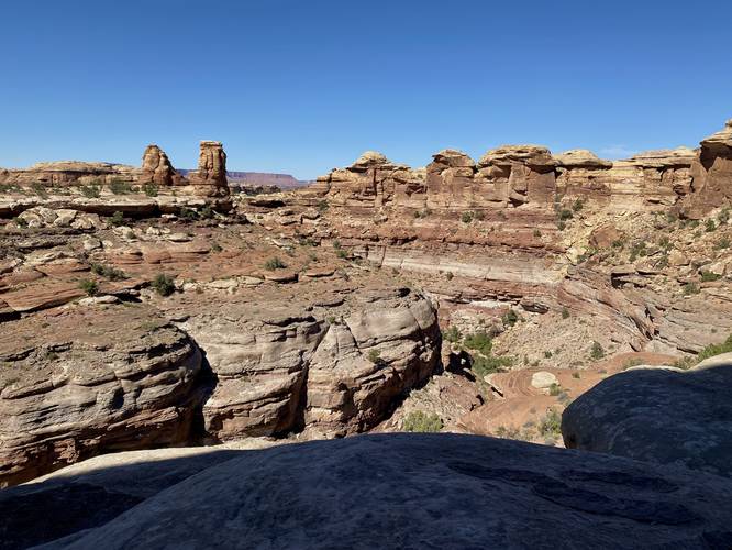
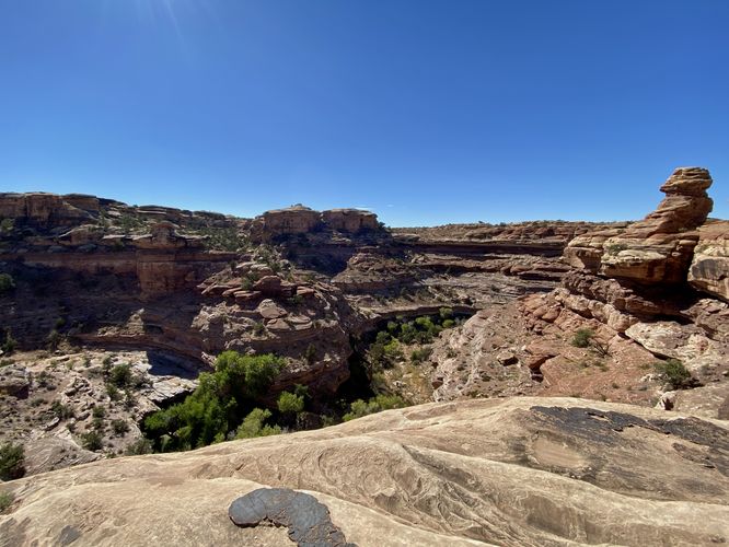
This hike begins at the very end of the Needles Main Park Road in Canyonlands and follows the trail on the western side of the cul-de-sac. This short trail is mostly-flat with minimal undulation along the way. The trail features views of the Big Spring Canyon from the trailhead, but the views get better as you hike in further. About half-way into the trail, hikers will find two towering rock cliffs with a gap between them -- here you can hike south for a couple-dozen feet to reach a south-facing view of Big Spring Canyon. We found this view to be the "best" one on the hike, but there are more views to take-in if you follow the trail further. Heading westward from the first view area, hikers will find that the trail heads down some steeper rock faces to reach a large viewing platform, located at the end of the trail, and of course at the edge of Big Spring Canyon. Here, hikers will get a northwest-facing view of Big Spring Canyon. Across the canyon, to the West, are large rock formations that resemble cupcakes. In the northwest distance, hikers will find a massive mesa sitting on the horizon. Below your feet is a several-hundred foot drop into Big Spring Canyon below.
Parking
Hikers will find parking at the coordinates provided -- located on the side of the road near the very end of Needles Main Park Road at Canyonlands National Park.
Pets
Dogs are not allowed on any trails at Canyonlands National Park. Please do not bring your dog here.
Warning
Sun exposure: This trail has very little shade and no water sources. Pack-in all water and wear sun screen and a hat to protect against sun exposure. It's smart to hike either in the early morning or late afternoon to avoid the intense desert sun.
Lack of water: Hikers must pack-in all water as there are no potable or filterable water sources along this trail. Rule of thumb in the desert is to pack-in 1 gallon of water per person per day.
Rattlesnakes: This is rattlesnake territory, so be on the lookout and give any rattlers you find plenty of space.
Steep cliffs: This trail follows steep cliffs. Watch your step and give yourself plenty of space from the edge of the cliffs for your own safety.
Fees
Vehicle entry fees to Canyonlands National Park is $30 as of September 2023.
Hike Description
This hike begins at the very end of the Needles Main Park Road in Canyonlands and follows the trail on the western side of the cul-de-sac. This short trail is mostly-flat with minimal undulation along the way. The trail features views of the Big Spring Canyon from the trailhead, but the views get better as you hike in further. About half-way into the trail, hikers will find two towering rock cliffs with a gap between them -- here you can hike south for a couple-dozen feet to reach a south-facing view of Big Spring Canyon. We found this view to be the "best" one on the hike, but there are more views to take-in if you follow the trail further. Heading westward from the first view area, hikers will find that the trail heads down some steeper rock faces to reach a large viewing platform, located at the end of the trail, and of course at the edge of Big Spring Canyon. Here, hikers will get a northwest-facing view of Big Spring Canyon. Across the canyon, to the West, are large rock formations that resemble cupcakes. In the northwest distance, hikers will find a massive mesa sitting on the horizon. Below your feet is a several-hundred foot drop into Big Spring Canyon below.
Parking
Hikers will find parking at the coordinates provided -- located on the side of the road near the very end of Needles Main Park Road at Canyonlands National Park.
Pets
Dogs are not allowed on any trails at Canyonlands National Park. Please do not bring your dog here.
Warning
Sun exposure: This trail has very little shade and no water sources. Pack-in all water and wear sun screen and a hat to protect against sun exposure. It's smart to hike either in the early morning or late afternoon to avoid the intense desert sun.
Lack of water: Hikers must pack-in all water as there are no potable or filterable water sources along this trail. Rule of thumb in the desert is to pack-in 1 gallon of water per person per day.
Rattlesnakes: This is rattlesnake territory, so be on the lookout and give any rattlers you find plenty of space.
Steep cliffs: This trail follows steep cliffs. Watch your step and give yourself plenty of space from the edge of the cliffs for your own safety.
Fees
Vehicle entry fees to Canyonlands National Park is $30 as of September 2023.