Loading...

🔥 End of Summer sale! 50% off on Supporter Accounts — now through September 1st. Learn More.

Big Schloss Hike

Directions
Map
Pictures
Send to App
Distance:
4.6 Miles / 7.4 km
Type:
Out-and-Back
Difficulty:
Easy
Time to Hike:
2 hours, ~18 minutes
Features:
Surface Type:
Dirt
Park:
George Washington National Forest
Town:
Edinburg, Virginia
Directions:
38.924046, -78.689489
Added:
January 23, 2025
Updated:
April 04, 2025
Guide by:
Copy Trail Link Hiking this trail? Send a friend or family member a link to this trail guide for your own safety. Hike at your own risk (disclaimer)
Loading...
Loading...
695'

Total Change
1,309'

Ascent
1,304'

Descent

Download the Trail Route for Offline Use

Supporters get exclusive access to download trail routes to the MyHikes app for offline use. Stay prepared on your adventure, even without an internet connection! Become a Supporter today to unlock this feature and hike with confidence.

Send to App

Big Schloss Hike

Big Schloss is another treasure in the George Washington National Forest. Relatively easy at only 4.4 miles and 1,000 vertical feet, it's the sister hike to Tibbet Knob which heads to the south from the same parking location. Tibbet Knob has two short rock scrabbles, but a 10th of the hikers, and just as good views.

Big Schloss peak, named by German immigrants provides a wonderful view of the surrounding valleys. Make sure to bring a packed lunch because you will want to linger at the Big Schloss rock outcropping and soak in the view.

If you want to make a weekend out of it, the Wolf Gap recreation area has 9 well maintained campsites with bathroom facilities. If you have some extra hiking time consider hiking the Tibbet Knob route as well. The views are every bit as good.

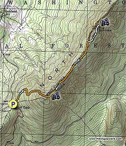
Mile 0.0 - Leave the Wolf Gap Campground (near campsite #9) and start up the orange blazed Mill Mountain Trail to begin the steepest portion of the hike. The first mile has several switch backs before arriving at the ridge line of Mill Mountain.

Once getting to the ridge line, turn left and continue following the now narrower trail as it follows the ridge before arriving at the junction of the Big Schloss Trail in 1.9 miles.

Turn right onto the white blazed Big Schloss Trail for another 0.3 miles before crossing a wooden bridge that will take you to the overlook just 50 yards further along. Enjoy the view it's one of the best! To return, just retrace your route back to the Wolf gap Campground.
Explore 79 trails near Edinburg, VA
  1. Parking

    38.924046, -78.689489
  2. Main Trailhead

    38.923703, -78.689575
No community routes found. To add your own hike as a Community Route for this Trail guide, leave a Trip Report with an attached GPX file.

Hazards

Ticks - Lyme Disease More Info (CDC)
Snakes
Poison Ivy/Oak

Seasons

All

Blaze Color

Orange

Trip Reports (Reviews)

Rated 4.45 out of 5 based on 100 ratings.
By: Chris
4.6 miles / 7.4 km
May 31, 2019
Did an early afternoon trip. I was moving at a pretty good pace as the weather was cool, so it took me about an hour to get up and 45 minutes to get back down after I spent 20 - 30 minutes up top. If I hadn't needed to get home, I would have spent longer up there as it is really quite nice to relax on the rocks. I came across three pairs on the way up, a group of 6 at the top and about four more people on the way down. Having the top to yourself is quite an experience. With the leaves having filled in, there aren't too many views on the way up. The mountain laurel was blooming which was nice and the trail had drained well enough that only a few spots were muddy. As an aside, there were quite a few spots where folks had made fires, including under a rock overhang near the top which I could smell was relatively fresh. It's forest service land, so perhaps that's legal but it certainly wasn't LNT... I wasn't aware this is a horse trail, but there was also evidence of horses having been on the trail recently, so beware as you're walking! This trail is now one of my favorites!
Legacy Review
By: Longhair the Tank
4.6 miles / 7.4 km
April 28, 2018
This is a very pretty hike, and the camping available at the recreational area is very nice. My group and I found great difficulty in the initial 800 ft climb to the first overlook. The grade in some places felt almost as steep as 45 degrees. After the initial climb, the trail just wandered along the ridge, and we reached Big Schloss for good break to take in the views.
Legacy Review
By: Rachel S.
4.6 miles / 7.4 km
April 14, 2018
THIS IS MY FAVORITE LOCAL HIKE (I live in Winchester)!!! It's amazing in the summer and fall. We just went in April and it was still beautiful but there was not much foliage. The great thing about that was that you could see even farther into the distance, but I prefer the greenery. The best time to go would be between July-October for the summer or fall views.
Legacy Review

Weather Forecast

In Edinburg, VA

Explore Hiking Trails

You May Also Like

New York's Best Waterfalls - Whether you're planning a day hike, roadside stop, or a leisurely short walk, this guide provides hikers, travelers, and locals alike with 63 different locations to over 100 scenic waterfalls to help plan your next adventure!
Explore

New York's Best Waterfalls

Whether you're planning a day hike, roadside stop, or a leisurely short walk, this guide provides hikers, travelers, and locals alike with 63 different locations to over 100 scenic waterfalls to help plan your next adventure!

Read
25 Best Day Hikes in North Carolina - Discover the top 25 best day hikes in North Carolina, from breathtaking waterfalls to mountain peaks. Explore hidden gems, scenic views, and trails suitable for all skill levels, perfect for your next outdoor adventure.
Explore

25 Best Day Hikes in North Carolina

Discover the top 25 best day hikes in North Carolina, from breathtaking waterfalls to mountain peaks. Explore hidden gems, scenic views, and trails suitable for all skill levels, perfect for your next outdoor adventure.

Read

Before you boogie...

Find our trail guides useful? Consider becoming a Supporter to unlock perks!

MyHikes is an indie platform that makes exploring public trails easier for everyone. The platform has no investors, no ads, and is owned and operated by one person, Dave Miller. Dave has personally mapped and written over 1,800 trail guides on MyHikes for the public to explore. MyHikes has helped millions outdoor enthusiasts plan their next adventure.

But it takes a lot of time 🕦, money 💰, work, and espresso shots ☕ to run MyHikes, including hiking , mapping , writing , and publishing new trails with high-quality (accurate) information... along with software engineering (coding) the platform like building new features, website and mobile app development (iOS and Android), site maintainance . and much much more.

Supporters unlock website and mobile app perks with an annual one-time payment of $25 (you renew) 😎👍. Or you can simply make a Donation of your choice. Otherwise, you can support us by telling your friends about MyHikes - both quick and free 🎉

Admin user profile picture

Dave Miller
MyHikes Founder