The Big Run Basin is the largest single watershed area in Shenandoah NP. 1 inch of rain in the basin equates to 200 million gallons of water to residents downstream.
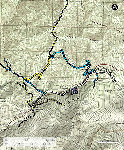
Park at the Doyles River Parking Area and then walk about 100 yards south on Skyline Drive to the Big Run Overlook. You could park at the overlook but there are not many spots there. The trailhead is at the south end of the overlook. Look for the walkway through the wall and the stone trail marker. Head to the left down the blue blazed Big Run Loop Trail. There are a few switchbacks on this gentle stroll down 1,100’ until you reach the first intersection in 2.2 miles. Just prior to this intersection you will cross Big Run which was not flowing much when we were there in late September.
At this intersection, which is about 200 yards after crossing Big Run, bear to the left to continue on the Big Run Loop Trail which is now yellow blazed. There is a little stretch of the next 1.5 miles that is strenuous but for the most part is not too tough as you climb 1000’ to the next intersection. Turn left to stay on the Big Run Loop Trail which is now blue blazed again. It is very gentle from here back to the parking at Doyles River.
In 0.6 miles you will intersect the A.T, bear to the left and in 0.3 miles you will cross Skyline Drive and in 0.5 miles you will go through the Doyles River Overlook with some great views (you may be sharing these views with car viewers). Proceed through the overlook parking area and pick up the A.T. again. In 0.8 miles you will come to the Doyle’s River parking intersection, bear left to arrive back at the parking lot in 50 yards. Bearing right at this intersection would take you to the Doyles River PATC cabin in 0.3 miles. This cabin can be rented from the PATC by non-members.
Alternative Starting Point: If camping at Loft Mountain you can take the A.T. South from the Loft Mountain Campground to the Doyles River Parking area. This adds about 1.1 miles each way. We were camping at Loft Mountain so this is the route we took. The spur trail from the campground to the A.T. South starts at the A-8 Tent Sites.