Big Falls Swimming Hole at Tioga State Forest near Morris, Pennsylvania is a moderate and steep 0.1-mile out-and-back trail that leads to the turquoise-colored swimming hole at Big Falls waterfall.
For a real hike that features a tranquil creek setting with more waterfalls and plenty of space to hang out off-trail, check out our Big Falls and Little Falls guide as an alternative hike which runs up the western side of Stony Fork.
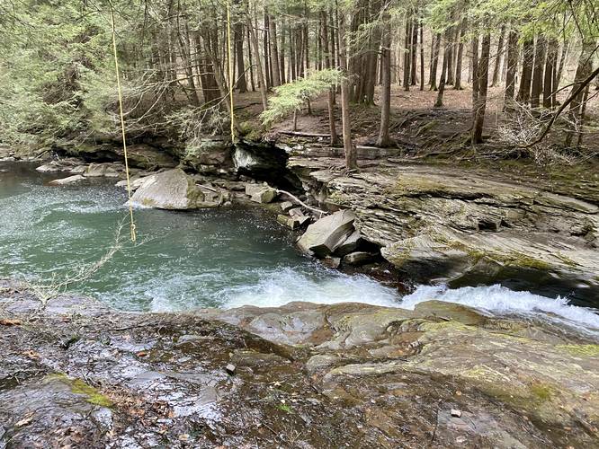
Swimming Hole
Below Big Falls is a deep swimming hole that's generally very popular during Summer months. If planning to swim at Big Falls, do not dive into the deep pool below the waterfall to avoid accidental injury or death. Swim at your own risk.
Hike Description
This hike begins at the coordinates provided - along Stony Fork Creek Road located exactly 4.9-miles south from the junction of Dibble Hill Road and Stony Fork Creek Road. The trail leads down a steep hillside with roots, rocks, and loose soil to reach the top of Big Falls on the eastern side of the waterfall. During the Summer and warmer months, the rocks surrounding the waterfall are generally dry, but during the Spring and periods of heavy rains, the bedrock surrounding the waterfall can be slippery and dangerous.
Note that during wetter months, there's not a whole lot of room to hang out next to Big Falls on this side of the creek.
Parking
Visitors and hikers will find a long parking turnout near the coordinates provided. The turnout can fit about 10 vehicles, lined down the west side of the road.
Pets
Dogs are allowed if leashed and cleaned up after.
Warnings
Steep terrain: The trail that leads down is pretty steep with a lot of leaves and loose soil that makes up the majority of the trail's substrate. I personally had to use my hands to hold onto rocks, trees, and stumps to ensure my footing going downhill. Use the rocks and roots to your advantage.
Slippery rocks: The bedrock surrounding Big Falls can be very slippery when wet which also slopes down into the deep pool in Stony Fork Creek.
Timber Rattlesnake: This area is home to the Timber Rattlesnake which can be found roaming the woods between April and October. Rattlers tend to hang out near creeks to drink, hunt, and sunbathe, so be on the lookout and give any rattlesnakes you find plenty of space.
For a real hike that features a tranquil creek setting with more waterfalls and plenty of space to hang out off-trail, check out our Big Falls and Little Falls guide as an alternative hike which runs up the western side of Stony Fork.
Swimming Hole
Below Big Falls is a deep swimming hole that's generally very popular during Summer months. If planning to swim at Big Falls, do not dive into the deep pool below the waterfall to avoid accidental injury or death. Swim at your own risk.
Hike Description
This hike begins at the coordinates provided - along Stony Fork Creek Road located exactly 4.9-miles south from the junction of Dibble Hill Road and Stony Fork Creek Road. The trail leads down a steep hillside with roots, rocks, and loose soil to reach the top of Big Falls on the eastern side of the waterfall. During the Summer and warmer months, the rocks surrounding the waterfall are generally dry, but during the Spring and periods of heavy rains, the bedrock surrounding the waterfall can be slippery and dangerous.
Note that during wetter months, there's not a whole lot of room to hang out next to Big Falls on this side of the creek.
Parking
Visitors and hikers will find a long parking turnout near the coordinates provided. The turnout can fit about 10 vehicles, lined down the west side of the road.
Pets
Dogs are allowed if leashed and cleaned up after.
Warnings
Steep terrain: The trail that leads down is pretty steep with a lot of leaves and loose soil that makes up the majority of the trail's substrate. I personally had to use my hands to hold onto rocks, trees, and stumps to ensure my footing going downhill. Use the rocks and roots to your advantage.
Slippery rocks: The bedrock surrounding Big Falls can be very slippery when wet which also slopes down into the deep pool in Stony Fork Creek.
Timber Rattlesnake: This area is home to the Timber Rattlesnake which can be found roaming the woods between April and October. Rattlers tend to hang out near creeks to drink, hunt, and sunbathe, so be on the lookout and give any rattlesnakes you find plenty of space.