Loading...

🎉 Find content tailored to you in the For You tab! Learn More.

Big Devils Stairs Hike

The Big Devils Stairs hike is one of the more overlooked scenic gorge hikes in the Shenandoah National Park. With two nice overlooks of the gorge and valley below, this 4.9 mile out and back hike is a nice alternative to the more crowded hikes in the northern section of the SNP.

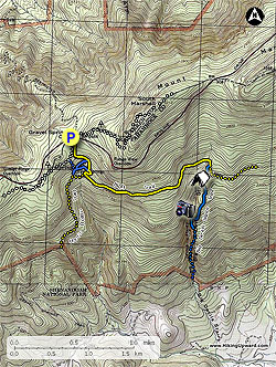
From the parking area at Gravel Springs Gap, pass the chain gate and follow the wide yellow blazed fire road as it heads downhill. The white blazed Appalachian Trail will follow the fire road on the right for the first 200 yards. The fire road will begin to descend more steeply before making a hairpin turn to the right at the first intersection.

Turn left following the narrower yellow blazed horse trail towards Big Devils Stairs (the fire road will now become blue blazed as it heads towards Gravel Springs Shelter). Follow the yellow blazed horse trail for 0.1 miles to the next intersection. Turn left remaining on the yellow blazed trail (again the blue blazed trail to the right goes to the shelter). In 200 yards the yellow blazed trail arrives at the intersection of the yellow blazed Bluff Trail.

Turn left on the yellow blazed Bluff trail towards Big Devils Stairs, as it heads north around the mountain for 1.4 miles to the intersection of the blue blazed Big Devils Stairs trail.

Turn right downhill on the blue blazed Big Devils Stairs Trail initially passing through an area of Mountain Laurel. In 150 yards there is one camp site on either side of the trail. The trail will then make several switchbacks in the next 0.4 miles to the first small overlook. Steeply descend rock steps and reach the first of the two main overlooks of the gorge and valley.

Continue down the trail for another 120 yards to the second overlook. Be cautions to watch your footing as the trail is narrow and passes close to the ledge in this section. The second overlook is the turn around point. From here the trail continues down to the stream and park boundary. There is no public access from the lower section of the trail.

Explore 91 trails near Bentonville, VA

Know Before You Go

  • Big Devils Stairs is a 4.9-mile out-and-back hike in Shenandoah National Park near Bentonville, VA, offering a less crowded alternative to other trails.
  • The trail is marked with yellow and blue blazes, requiring multiple turns at intersections to reach the overlooks, so pay attention to the trail markers.
  • The hike features two overlooks with scenic views of the gorge and valley, with the second overlook serving as the turnaround point due to no public access beyond.
Interactive topographic map for Big Devils Stairs Hike located in Bentonville, VA. Click the "View Map" button to load GPS coordinates and trail markers.
Get directions
Distance
4.9 mi
Difficulty
Moderate
Type
Out-and-Back
Est. Time
2.5 hrs
Elev. Gain
1,048'
Rating
3.6
Added
March 18, 2025
Updated
April 05, 2025

Weather Forecast

Loading...
Total Change
760'
Ascent
1,048'
Descent
1,048'
Loading...

Download the GPX Data for Offline Use

Supporters get exclusive access to download trail routes to the MyHikes app for offline use. Stay prepared on your adventure, even without an internet connection! Become a Supporter today to unlock this feature and hike with confidence.

Download Big Devils Stairs Hike GPX Data to the MyHikes Mobile App

Features

Vista / Lookout Point
Dogs
Waterfalls
Camping
Water Source
Appalachian Trail logo Appalachian Trail hike

Points of interest

  1. Parking

    38.767662, -78.233471
  2. Main Trailhead

    38.767904, -78.2336

Safety information

For your own safety: plan ahead, let someone know where you'll be, and hike at your own risk.

Hazards

Snakes (Rattlesnakes, Copperheads, others)
Poison Ivy or Poison Oak

Markers

Blaze Color

Yellow

Availability

All seasons

Surface type

Dirt

Trip Reports (Reviews)

Rated 3.57 out of 5 based on 37 ratings.

Ready to help fellow hikers? Add a trip report to share your experience and provide valuable insights for other hikers!

By: Laurie
4.9 miles / 7.9 km
November 09, 2019
The hike was just the right length - the views of the gorge at the end were great! The blazes on the trees could have been better. Just an FYI - the parking lot is 13.8 miles North from the Thornton Gap entrance gate.
Legacy Review
By: Jamey
4.9 miles / 7.9 km
March 30, 2018
Since it was supposed to rain, I wanted a quick and easy hike, and this fit the bill. The views from the overlooks are certainly nice, but they're not spectacular. The woods here are boring, scraggly, and rocky. I didn't see anybody, but I heard a loud group at Gravel Springs Hut. While it's always nice to be out in the woods, I wasn't expecting much, and this hike is nothing special. In fact, it's one of the least impressive of the dozens of hikes I've done in SNP.
Legacy Review
By: nort
4.9 miles / 7.9 km
August 13, 2017
The hike from gravel springs hut is easy and quick. The views from the overlooks are pretty great. The bottom of the trail at the park boundary was kind of boring, so I went back up via the stream bed. It's pretty fun. Once you're almost at the top the stream bed flattens out. I climbed up the rocks on the trail side to where the first overlook is. It was pretty easy and fun. Once up there I knew i just had to walk a short distance to find the trail, and instead I found a yellowjacket nest and got stung a bunch of times. And lost my sunglasses. So if you go that way, watch out for bees. And if you find some Native sunglasses in the middle of the woods near the hive, hit me up, please!
Legacy Review
No community routes found. To add your own hike as a Community Route for this Trail guide, leave a Trip Report with an attached GPX file.

Popular categories

Scenic mountain view representing vista trails
Vista trails
Scenic gorge of cascades representing waterfall trails
Waterfall hikes
Rugged mountain terrain representing summit trails
Summit trails
Scenic mountain view representing dog-friendly trails
Dog-friendly
Scenic campsite with a view representing camping trails
Camping trails
Appalachian Trail logo representing A.T. hikes
A.T. hikes

You May Also Like

25 Best Day Hikes in North Carolina - Discover the top 25 best day hikes in North Carolina, from breathtaking waterfalls to mountain peaks. Explore hidden gems, scenic views, and trails suitable for all skill levels, perfect for your next outdoor adventure.
Explore

25 Best Day Hikes in North Carolina

Discover the top 25 best day hikes in North Carolina, from breathtaking waterfalls to mountain peaks. Explore hidden gems, scenic views, and trails suitable for all skill levels, perfect for your next outdoor adventure.

Read
🍪 We use cookies to learn about site usage and to serve map tiles. You may block cookies manually in the browser. By continuing you agree. Learn more