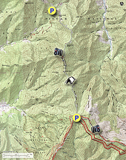
The Big Butt Trail, despite its comical name, is a tough hike along the western peaks of the Black Mountains. Most hikers begin at the Balsam Gap trailhead on the Blue Ridge Parkway, the easier way to reach the viewpoints. This is seasonal access however, since the parkway is typically closed all winter in this section. Year-round access is possible at Cane River Gap, deep in the backcountry of the Big Ivy section of the Pisgah National Forest.
You may think of the Big Butt Trail as the little cousin to the Black Mountain Crest Trail. It is shorter, not as difficult, and crosses peaks just below 6,000 feet. At the beginning you’ll face a long, switchbacking ascent through beautiful hardwood forests to the mile-high ridgeline between Big Butt and Little Butt. The Black Mountains form a U around the Cane River Valley, but all of the tall, well-known peaks are on the east side of the range. That doesn’t diminish the hike though, it provides arguably the best views of the eastern Black Mountains from Little Butt. After Little Butt the trail continues south past Point Misery then ends at Balsam Gap. From here you have the option of following the Mountains-to-Sea Trail east to a great view below the 6,320-foot Blackstock Knob. Once you reach the summit turn around for a tiring 7.6-mile hike back to Cane River Gap. There are also multiple options for a shuttle hike. Leave a car at Balsam Gap for the shortest possible shuttle. You can also follow the MST east to the crossing on NC 128 below Potato Knob, or west to the Glassmine Falls Overlook or Graybeard Mountain Overlook.
Alternate Parking: Walker Knob Overlook (Balsam Gap) – If the Blue Ridge Parkway is open to Walker Knob Overlook at Balsam Gap you can do a shorter, easier version of this hike. You can hike out to Big Butt, turn around, and choose to add Blackstock Knob if you wish. This hike is 9.7 miles with 2,850 feet elevation gain.
Mile Summary and Highlights 0.0 - Big Butt Trailhead at NC 197 (Cane River Gap)3.2 - Big Butt summit (5,920 feet)
4.1 - Little Butt summit with views east of the Black Mountains
5.0 - Pass by the summit of Point Misery (5,715 feet)
6.5 - Big Butt Trailhead and Mountains-to-Sea Trail junction at Walker Knob Overlook (Balsam Gap)
7.8 - Northeast view of Black Mountains from Mountains-to-Sea Trail
8.1 - Blackstock Knob summit (6,340 feet) and hike turnaround point
- Mile 0.0 – At the end of the small parking area the Big Butt Trail [161] (white diamond blaze) splits to the left from Cane River Gap. Avoid the gated forest road on the right. This hikers’ only trail has seen recent improvements from the NC High Peaks Association and is generally in excellent condition. For the next 1.5 miles you will climb approximately 1,200 feet using many switchbacks.
- Mile 1.5 – The trail levels out on the top of Wilson Ridge and the grade lessens significantly as you continue towards Flat Spring Knob.
- Mile 2.2 – The trail swings around the north side of Flat Spring Knob. You should be able to see the conical summit of Big Butt up ahead.
- Mile 3.0 – Y-junction with a side trail on the right to Big Butt Mountain. There is a small campsite at the beginning of this trail. The unofficial manway has faded red blazes. It is easy to follow but overgrown with weeds.
- Mile 3.2 – Reach the summit of Big Butt Mountain. The summit at 5,920 feet is adorned with weather-beaten trees and shrubs. There is a good view from open rocks to the northwest of the northern Great Craggy Mountains and the Bald Mountains further in the distance.
- Mile 3.5 – Back at the Y-junction follow the Big Butt Trail south.
- Mile 3.6 – Along a high, narrow ridge covered with withered rhododendrons and blueberry bushes is an open view southwest of the Great Craggy Mountains and west of the Ivy Creek Valley. If you hike this midsummer you may be able to forage for wild blueberries.
- Mile 3.9 – Open view south and east from a rock outcrop.
- Mile 4.1 – On the right side of the trail is a campsite beneath the canopy. Immediately past this spot the trail passes the summit of Little Butt. On your left is a large rock outcrop with open views south and east. The high crest of the eastern Black Mountains stretches out before you. The range forms a U around the deep, remote Cane River Valley. Immediately south the rounded, forested peak is Point Misery with the tip of Blackstock Knob appearing in the distance. Once you locate the communications towers on Clingmans Peak you can start naming the mountains and gaps sequentially to the left. After Mt. Gibbes the ridge drops to Stepps Gap, rising moderately to Mt. Hallback before gradually ascending to the unremarkable summit of Mt. Mitchell. The next double peaks are Mt. Craig and Big Tom. The ridge briefly dips to Big Tom Gap before rising high again to Balsam Cone and Cattail Peak. Deep Gap is the deepest notch in the range and divides the central Blacks from the shorter northern Blacks. Winter Star Mountain is distinguishable above the commanding 6,000-foot ridge that culminates in Celo Knob. After Celo Knob the land drops thousands of feet to the valleys of the Cane River and South Toe River. Once you’ve finished admiring the views from Little Butt, continue south on the Big Butt Trail. The trail steeply descends the mountain on a long series of well-built steps to a saddle between Little Butt and Point Misery.
- Mile 5.0 – The Big Butt Trail skirts by the summit of Point Misery (5,715 feet). The summit marker is on your left a few yards from the trail. The trail now gradually descends Brush Fence Ridge through a variety of forests to Balsam Gap.
- Mile 6.5 – The Big Butt Trail ends at the Walker Knob Overlook (Balsam Gap) on the Blue Ridge Parkway. Turn left and follow the Mountains-to-Sea Trail [440] (white blaze) east towards Blackstock Knob.
- Mile 7.3 – After the series of switchbacks the trail follows a ~6,000-foot ridgeline through a southern Appalachian spruce-fir forest.
- Mile 7.8 – On the left side of the trail is an expansive view north of the Cane River Valley surrounded by the Black Mountains. From here you can see Celo Knob in the far north and trace the Black Mountains all the way to Clingmans Peak.
- Mile 8.1 –The MST crosses the sparse, tree-covered summit of Blackstock Knob (6,340 feet). Turn around here heading back towards the Walker Knob Overlook.
- Mile 9.7 –At the Walker Knob Overlook, turn right on the Big Butt Trail heading north towards your car at Cane River Gap.
- Mile 14.3 –Hike ends at the NC 197 trailhead (Cane River Gap).