Loading...

WINTER SALE! 50% OFF Supporter Accounts — now through January 31st. Learn More.

Belle Isle Hike

Belle Isle is a deceptively named, family friendly, wheelchair accessible hike in the middle of the James River with the downtown skyline of Richmond, VA visible in the background. If you just walked around and looked only at the river, the trees, the birds, the climbing cliffs, etc, you would certainly agree that it is a “Belle Isle”. On the other hand if you read some of the posted signs and looked around at the evidence of its prior use, you might be transported back to a time when it was not a Belle Isle: a granite quarry pit, a power plant, an iron milling factory, an iron foundry, and the most haunting of all – A Civil War prison camp where over 1,000 Union soldiers died from deprivation.

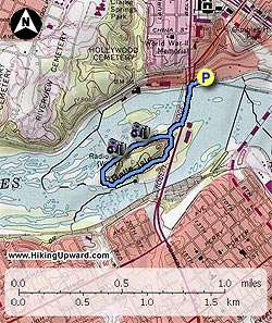
From the parking lot, head under the train trestle to the sidewalk and take a right heading to the hanging bridge underneath the Lee Bridge (Route 1/301). It is about 0.5 miles to the other side of the bridge from the parking area. Stay straight as you come off the foot bridge and go about 100 yards and bear to the right following the river. The area to the right at this intersection was the Civil War Prison Camp cemetery (bodies since removed). Continue following the trail along the river with many side paths leading to rocks on the river that have great photo opportunities. Caution: during times when the river is high it is not advisable to go rock hopping. The summer sees many people out here for the day relaxing on the rocks getting their feet wet.

The cemetery visible on the opposite bank is the Hollywood Cemetery where Presidents Monroe and Tyler are buried along with President of the Confederacy Jefferson Davis, Confederate General JEB Stuart and thousands of civil war soldiers.

About 0.4 miles from the first intersection you will see the rock quarry and pond on the left. Rock climbing is allowed in the quarry but at your own risk. 200 yards beyond the quarry is a picnic area with some more opportunities for exploring the rocks on the river. 150 yards beyond the picnic area is a side trail to see some of the remnants of the power plant dam and more rock exploring. Continuing on the main loop trail, keep an eye out for the power plant and iron mill (made nails, wire, horseshoes, etc) and take a left in about 0.4 miles to head back to the foot bridge. From this point it is about 0.6 miles back to the parking area. The steel framed building on the right just before the bridge is the old iron foundry.

It may take you more than 1 hour to hike this trail if you stop and look at the many interesting views of the river and the remnants of Belle Isle’s past.

Note: As of 2010 a new accessible ramp to the rocks was completed in Dec 2010. The ramp is approximately 0.5 miles after getting off the bridge. Be aware, there is only 1 dedicated Handicapped Parking Spot at the Belle Isle parking area, it is the last spot prior to the sidewalk leading to the bridge.

Explore 2 trails near Richmond, VA

Know Before You Go

  • Belle Isle, located in Richmond, VA, offers a short, accessible 1.6-mile hike with views of the city skyline and James River.
  • The island's history is multifaceted, encompassing natural beauty alongside remnants of industrial activities and a Civil War prison camp.
  • The trail provides opportunities for exploration, photography, and rock climbing (at your own risk), with notable landmarks including a rock quarry, picnic area, and remnants of historical structures.
Interactive topographic map for Belle Isle Hike located in Richmond, VA. Click the "View Map" button to load GPS coordinates and trail markers.
Get directions
Distance
1.6 mi
Difficulty
Easy
Type
Loop
Est. Time
48 min
Elev. Gain
86'
Rating
4.2
Added
April 03, 2025
Updated
April 06, 2025

Weather Forecast

Loading...
Total Change
41'
Ascent
86'
Descent
85'
Loading...

Download the GPX Data for Offline Use

Supporters get exclusive access to download trail routes to the MyHikes app for offline use. Stay prepared on your adventure, even without an internet connection! Become a Supporter today to unlock this feature and hike with confidence.

Download Belle Isle Hike GPX Data to the MyHikes Mobile App

Features

Vista / Lookout Point
Dogs
Water Source

Points of interest

  1. Parking

    37.534686, -77.448026
  2. Main Trailhead

    37.534564, -77.448324

Safety information

For your own safety: plan ahead, let someone know where you'll be, and hike at your own risk.

Availability

All seasons

Surface type

Universal Access

Trip Reports (Reviews)

Rated 4.2 out of 5 based on 5 ratings.

Ready to help fellow hikers? Add a trip report to share your experience and provide valuable insights for other hikers!

By: Jessie R.
1.6 miles / 2.6 km
September 01, 2015
I used to live within walking distance and hiked here all the time. If you want a longer/more challenging hike you can combine it with a lot of nearby places, like Manchester climbing wall, Reedys Creek, or take the Buttermilk Trail down to Byrd Park to see Pump House. There's a lot to explore at Belle's and the surrounding area. The only thing I don't like about this park is there are a lot of people who take their dog off leash here, which is fine if they have good recall or can leash their dog for me to pass with my dog, but I've had too many encounters where that was not the case. It also is pretty crowded there, even on really rainy or snowy days there are always people there.
Legacy Review
By: Jeb
1.6 miles / 2.6 km
October 17, 2011
I routinely hike/power walk from the VA War Memorial down to Belle Isle & back during lunch hours. You can do this whole circuit in about 45 minutes with decent pace. During warm weather, sometimes the rocks can be overcrowded with VCU students pretending they're at the beach, but it's really fascinating to go when it's cooler & there aren't so many people there. The water views are spectacular and for me, it's not uncommon to sense the presence of other walkers following behind who aren't actually there. There are bathroom facilities, pet relief stations, and I think there might be a water fountain or two, as well as at least one covered picnic area, so it's definitely family-friendly. A great location for history-minded hikers, fitness buffs, and casual walkers alike.
Legacy Review
By: HikingUpward
1.6 miles / 2.6 km
January 15, 2011
We went back here to check out a new accessible ramp down onto the rocks. What a great job the City of Richmond did with the ramp. It is on the right less than 1/2 mile after coming off the foot-bridge. New photo will be added soon. This is a great little hike and the last 2 times we have been, we have seen a Bald Eagle and 2 Hawks, so keep your eyes open.
Legacy Review
No community routes found. To add your own hike as a Community Route for this Trail guide, leave a Trip Report with an attached GPX file.

Popular categories

Scenic mountain view representing vista trails
Vista trails
Scenic gorge of cascades representing waterfall trails
Waterfall hikes
Rugged mountain terrain representing summit trails
Summit trails
Scenic mountain view representing dog-friendly trails
Dog-friendly
Scenic campsite with a view representing camping trails
Camping trails
Appalachian Trail logo representing A.T. hikes
A.T. hikes

You May Also Like

25 Best Day Hikes in North Carolina - Discover the top 25 best day hikes in North Carolina, from breathtaking waterfalls to mountain peaks. Explore hidden gems, scenic views, and trails suitable for all skill levels, perfect for your next outdoor adventure.
Explore

25 Best Day Hikes in North Carolina

Discover the top 25 best day hikes in North Carolina, from breathtaking waterfalls to mountain peaks. Explore hidden gems, scenic views, and trails suitable for all skill levels, perfect for your next outdoor adventure.

Read
🍪 We use cookies to learn about site usage and to serve map tiles. You may block cookies manually in the browser. By continuing you agree. Learn more