Loading...

🎉 Enjoy a Free 7-Day Supporter Trial and Unlock Exclusive Perks — No Credit Card Required. Learn more.

Beaverdam Reservoir Hike

Directions
Map
Pictures
Send to App
Distance:
7.6 Miles / 12.2 km
Type:
Loop
Difficulty:
Moderate
Time to Hike:
3 hours, ~48 minutes
Features:
Surface Type:
Dirt
Town:
Brambleton, Virginia
Directions:
38.998438, -77.532624
Added:
April 03, 2025
Updated:
April 06, 2025
Copy Trail Link Hiking this trail? Send a friend or family member a link to this trail guide for your own safety. Hike at your own risk (disclaimer)
Loading...
Loading...
85'

Total Change
300'

Ascent
309'

Descent

Download the Trail Route for Offline Use

Supporters get exclusive access to download trail routes to the MyHikes app for offline use. Stay prepared on your adventure, even without an internet connection! Become a Supporter today to unlock this feature and hike with confidence.

Send to App

Beaverdam Reservoir Hike

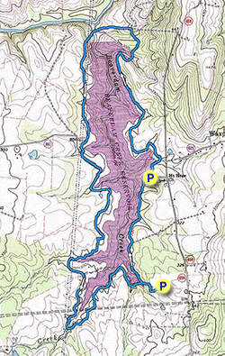
The Beaverdam Reservoir is located in Loudoun County VA, and is a partnership between Northern Virginia Regional Parks and Loudoun Water. There are over 600 acres of parkland available for hiking, fishing, and non-motorized water sports. Swimming and wading is prohibited. There are three main access points, from the National Recreation and Park Association building area, the end of Mt. Hope Rd, and at the end of Reservoir Road on the western side of the reservoir.

The main hiking circuit described below is 7.7 miles and circumnavigates the reservoir.

Keep an eye out for Box Turtles that are very prevalent in the park. We came across six of them when hiking the circuit in October.

  • Mile 0.0 – Start the hike from the National Recreation and Park building and follow the connector trail down to the reservoir and intersection with the blue blazed perimeter trail. There is a small creek on the left.

  • Mile 0.2 - Stay right on the blue blazed trail as it follows the banks of the reservoir This area has some of the nicest views, and is also a popular with people fishing. The blue perimeter trail will follow also service road, pass around a reed filled wetland area, and cross a small stream before arriving at the parking area at the end of Mt Hope road.

  • Mile 1.2 - The continuation of the blue blazed perimeter trail is at the top end of the parking area to the right of the informational signs, not directly ahead. Look for the blue blazes to verify you are on the correct trail. The trail continues around the reservoir, then joins the service road for the dam.

  • Mile 2.9 - Turn left on the service road and pass around the rear of the dam. Climb the grass embankment on the left where the service road veers right. At the top of the embankment rejoin the service road and perimeter trail.

  • Mile 3.9 - The trail veers left reentering the woods.

  • Mile 4.1 - Pass around a closed gate and a third parking area at the end of Reservoir Road. The blue blazed perimeter trail re-enters the woods on the other side. The perimeter trail uses several access roads and passes back through the powerline clearcute. Follow the perimeter trail signs.

  • Mile 6.3 - Cross the reservoir feeder stream and souther point of the hike.

  • Mile 7.4 - Cross the largest of the reservoir feeder streams.

  • Mile 7.5 - Arrive back at the start of the loop and turn right back towards the National Recreation and Park building.

  • Mile 7.6 - Arrive back at the National Recreation and Park building and parking area.

Explore 37 trails near Brambleton, VA
  1. Parking

    38.998438, -77.532624
  2. Main Trailhead

    38.998438, -77.532624
No community routes found. To add your own hike as a Community Route for this Trail guide, leave a Trip Report with an attached GPX file.

Hazards

Ticks - Lyme Disease More Info (CDC)
Snakes
Poison Ivy/Oak

Seasons

All

Blaze Color

Blue

Trip Reports

Trail Guide By:
HikingUpward user profile picture
7.6 miles / 12.2 km

Weather Forecast

In Brambleton, VA

Explore Hiking Trails

You May Also Like

New York's Best Waterfalls - Whether you're planning a day hike, roadside stop, or a leisurely short walk, this guide provides hikers, travelers, and locals alike with 63 different locations to over 100 scenic waterfalls to help plan your next adventure!
Explore

New York's Best Waterfalls

Whether you're planning a day hike, roadside stop, or a leisurely short walk, this guide provides hikers, travelers, and locals alike with 63 different locations to over 100 scenic waterfalls to help plan your next adventure!

Read
25 Best Day Hikes in North Carolina - Discover the top 25 best day hikes in North Carolina, from breathtaking waterfalls to mountain peaks. Explore hidden gems, scenic views, and trails suitable for all skill levels, perfect for your next outdoor adventure.
Explore

25 Best Day Hikes in North Carolina

Discover the top 25 best day hikes in North Carolina, from breathtaking waterfalls to mountain peaks. Explore hidden gems, scenic views, and trails suitable for all skill levels, perfect for your next outdoor adventure.

Read

Before you boogie...

Find our trail guides useful? Consider becoming a Supporter to unlock perks!

MyHikes is an indie platform that makes exploring public trails easier for everyone. The platform has no investors, no ads, and is owned and operated by one person, Dave Miller. Dave has personally mapped and written over 1,800 trail guides on MyHikes for the public to explore. MyHikes has helped millions outdoor enthusiasts plan their next adventure.

But it takes a lot of time 🕦, money 💰, work, and espresso shots ☕ to run MyHikes, including hiking , mapping , writing , and publishing new trails with high-quality (accurate) information... along with software engineering (coding) the platform like building new features, website and mobile app development (iOS and Android), site maintainance . and much much more.

Supporters unlock website and mobile app perks with an annual one-time payment of $25 (you renew) 😎👍. Or you can simply make a Donation of your choice. Otherwise, you can support us by telling your friends about MyHikes - both quick and free 🎉

Admin user profile picture

Dave Miller
MyHikes Founder