Loading...

WINTER SALE! 50% OFF Supporter Accounts — now through January 31st. Learn More.

Beartown Boulders Hike

This is not your usual HikingUpward location – many might claim it is not a hike at all! But if you find yourself in West Virginia on U.S. 219 between Marlinton and Lewisburg, say on your way to the Cranberry Wilderness, this delightful detour is well worth your time. And if you have travelers aged 10 or younger, this is a must see. They will love it at least as much as you do!

Note that the park is open daily from April to October. During the closed winter season the park notes that “foot travel to the boardwalk area is welcome, with parking available at the closed entrance gate,” creating a slightly longer access walk.

No fee is charged to visit Beartown State Park, and no camping is allowed. The land was purchased in 1970 with funds from the Nature Conservancy and a donation in memory of a local soldier who lost his life in the Vietnam War. The Beartown name was chosen because local residents claimed that many cave-like openings in the rocks made perfect winter dens for black bears.

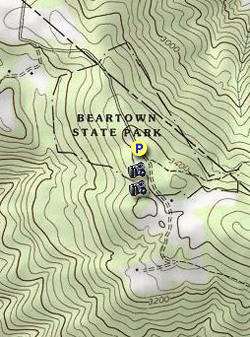
  • Mile 0.0 – The main parking area has picnic tables and privies. Access to the rock formations is via a gravel trail on the south end of the lot.  
  • Mile 0.1 – The gravel base gives way to a boardwalk, which crosses over a ravine. Just after this, the boardwalk offers two directions – you can complete the loop either clockwise or counter-clockwise. We took a right and the followed the boardwalk as it weaved in among large sandstone boulders topped by rock cap ferns, over large crevices, and sometimes through the boulders. Be ready to squeeze! The rocks themselves have interesting fractures, holes, and a variety of plant life.
  • Mile 0.3 – At about the halfway point, the boardwalk reaches a second access. This is for handicapped visitors, and includes a small platform for those with mobility issues to view the rocks. From here, the boardwalk ascends, giving the visitor a higher view of the area.
  • Mile 0.4 - The upper part of the boardwalk returns you to the beginning of the loop. If you have young visitors with you, they will probably vote to loop the trail again!
  • Mile 0.6 – A short stroll has you back at the parking lot and picnic area.
By HikingUpward Contributor: Jeff Monroe
Explore 22 trails near Renicks Valley, WV

Know Before You Go

  • Beartown State Park in Renicks Valley, WV, offers a unique 0.6-mile boardwalk trail through impressive rock formations, making it a worthwhile detour between Marlinton and Lewisburg.
  • The park is open April-October with free admission, featuring picnic facilities and a boardwalk loop suitable for all ages, including young children who will especially enjoy exploring the boulder-filled landscape.
  • During the closed winter season, foot access is still allowed, but visitors should park at the closed gate and walk to the boardwalk area, and the park's name originates from local tales of black bears using the rock formations as dens.
Interactive topographic map for Beartown Boulders Hike located in Renicks Valley, WV. Click the "View Map" button to load GPS coordinates and trail markers.
Get directions
Distance
0.6 mi
Difficulty
Easy
Type
Loop
Est. Time
18 min
Elev. Gain
147'
Rating
0.0
Added
March 20, 2025
Updated
April 06, 2025

Weather Forecast

Loading...
Total Change
52'
Ascent
147'
Descent
153'
Loading...

Download the GPX Data for Offline Use

Supporters get exclusive access to download trail routes to the MyHikes app for offline use. Stay prepared on your adventure, even without an internet connection! Become a Supporter today to unlock this feature and hike with confidence.

Download Beartown Boulders Hike GPX Data to the MyHikes Mobile App

Features

Dogs

Points of interest

  1. Parking

    38.051477, -80.275153
  2. Main Trailhead

    38.05142, -80.27526

Safety information

For your own safety: plan ahead, let someone know where you'll be, and hike at your own risk.

Hazards

Snakes (Rattlesnakes, Copperheads, others)

Availability

All seasons

Surface type

Dirt

Trip Reports (Reviews)

Your opinion matters! Be the first to rate this trail.

Ready to help fellow hikers? Add a trip report to share your experience and provide valuable insights for other hikers!

No community routes found. To add your own hike as a Community Route for this Trail guide, leave a Trip Report with an attached GPX file.

Popular categories

Scenic mountain view representing vista trails
Vista trails
Scenic gorge of cascades representing waterfall trails
Waterfall hikes
Rugged mountain terrain representing summit trails
Summit trails
Scenic mountain view representing dog-friendly trails
Dog-friendly
Scenic campsite with a view representing camping trails
Camping trails
Appalachian Trail logo representing A.T. hikes
A.T. hikes

You May Also Like

Colorado's Million Dollar Highway - Plan a day's drive adventure along the iconic Million Dollar Highway in Colorado. Explore the best short trails, roadside stops, waterfalls, vistas, ghost towns, and hot springs within a ~6 hour road trip.
Explore

Colorado's Million Dollar Highway

Plan a day's drive adventure along the iconic Million Dollar Highway in Colorado. Explore the best short trails, roadside stops, waterfalls, vistas, ghost towns, and hot springs within a ~6 hour road trip.

Read
🍪 We use cookies to learn about site usage and to serve map tiles. You may block cookies manually in the browser. By continuing you agree. Learn more