Loading...

🎆 50% off 4th of July sale on Supporter Accounts — now through July 6! Learn More.

Beards Mountain Hike

Directions
Map
Pictures
Send to App
Distance:
6.2 Miles / 10.0 km
Type:
Loop
Difficulty:
Moderate
Time to Hike:
3 hours, ~6 minutes
Features:
Surface Type:
Dirt
Town:
Millboro, Virginia
Directions:
37.895755, -79.802069
Added:
April 03, 2025
Updated:
April 06, 2025
Copy Trail Link Hiking this trail? Send a friend or family member a link to this trail guide for your own safety. Hike at your own risk (disclaimer)
Loading...
Loading...
1,230'

Total Change
1,690'

Ascent
1,689'

Descent

Download the Trail Route for Offline Use

Supporters get exclusive access to download trail routes to the MyHikes app for offline use. Stay prepared on your adventure, even without an internet connection! Become a Supporter today to unlock this feature and hike with confidence.

Send to App

Beards Mountain Hike

Douthat State Park is one of Virginia's jewels. Voted as one of the nations 10 best, the park has over 43 miles of trails. Beards Mountain has just as many beautiful vistas as the Blue Suck Falls Hike, the other circuit hike in Douthat State Park. Both hikes also have an abundance of Mountain laurel that blooms in early June.

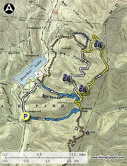
The blue blazed Beards Gap Trail starts up right side of the Visitor Center, and initially passes over a wooden footpath. Follow the blue blazed trail as it heads up the gap. The trail will make several switchbacks before arriving at the ridge, and intersection of the Bushy Hollow and Mountain Top trails in 1.1 miles.

Turn left on the yellow blazed Mountain Top Trail as it continues to climb along the ridge. In 0.2 miles the trail will make a sharp turn to the right. To the left is a closed overlook trail. In 200 yards reach the 4-way intersection of the Buck Hollow and Mountain Side trails. Stay straight on the yellow blazed Mountain Top Trail and in 0.1 miles the trail will make a sharp turn to the right and pass the first vista of Douthat Lake. From this point, the trail will climb more steeply before leveling off and arriving a the circuit high point.

There is a marker for the GWNF here, and what a appears to be a trail continuing straight. Stay left downward on the yellow blazed trail as it follows the ridge, before descending more steeply and passing the best vista of Lake Douthat. The trail will now turn back to the left and in another 0.4 miles reach the intersection of the Ross Camp and Mountain Side trails.

Turn left on the white blazed Mountain Side Trail and reach the third vista in 0.9 miles. From this vista the trail will gradually begin to climb back to the ridge and reach the 4-way intersection of the Mountain Top and Buck Hollow trails in 0.4 miles.

Turn right downhill on the blue blazed Buck Hollow Trail as it steeply descends the mountain reaching an Overlook Trail in 0.5 miles. The Overlook Trail is a 0.5 miles out/back that takes you to a panoramic vista of the park. Continue down on the Buck Hollow Trail for 0.4 miles to the next 4-way intersection with the Ross Camp and Wilson Creek trails.

Turn left on the white blazed Wilson Creek Trail, immediately crossing a small footbridge. The white blazed trail will pass a water tower in 0.1 miles, then turn left into the woods. DO NOT continue straight on the gravel road. Follow the white blazed trail for 0.3 miles where it crosses a camp road then ends at an stone chimney and The Lodge.

Pass around The Lodge, back to the Visitors Center and parking.

Explore 24 trails near Millboro, VA
  1. Parking

    37.895755, -79.802069
  2. Main Trailhead

    37.896869, -79.801362
No community routes found. To add your own hike as a Community Route for this Trail guide, leave a Trip Report with an attached GPX file.

Hazards

Ticks - Lyme Disease More Info (CDC)
Snakes
Poison Ivy/Oak

Seasons

All

Trip Reports

Trail Guide By:
HikingUpward user profile picture
6.2 miles / 10.0 km

Weather Forecast

In Millboro, VA

Explore Hiking Trails

You May Also Like

New York's Best Waterfalls - Whether you're planning a day hike, roadside stop, or a leisurely short walk, this guide provides hikers, travelers, and locals alike with 63 different locations to over 100 scenic waterfalls to help plan your next adventure!
Explore

New York's Best Waterfalls

Whether you're planning a day hike, roadside stop, or a leisurely short walk, this guide provides hikers, travelers, and locals alike with 63 different locations to over 100 scenic waterfalls to help plan your next adventure!

Read
25 Best Day Hikes in North Carolina - Discover the top 25 best day hikes in North Carolina, from breathtaking waterfalls to mountain peaks. Explore hidden gems, scenic views, and trails suitable for all skill levels, perfect for your next outdoor adventure.
Explore

25 Best Day Hikes in North Carolina

Discover the top 25 best day hikes in North Carolina, from breathtaking waterfalls to mountain peaks. Explore hidden gems, scenic views, and trails suitable for all skill levels, perfect for your next outdoor adventure.

Read

Before you boogie...

Find our trail guides useful? Consider becoming a Supporter to unlock perks!

MyHikes is an indie platform that makes exploring public trails easier for everyone. The platform has no investors, no ads, and is owned and operated by one person, Dave Miller. Dave has personally mapped and written over 1,800 trail guides on MyHikes for the public to explore. MyHikes has helped millions outdoor enthusiasts plan their next adventure.

But it takes a lot of time 🕦, money 💰, work, and espresso shots ☕ to run MyHikes, including hiking , mapping , writing , and publishing new trails with high-quality (accurate) information... along with software engineering (coding) the platform like building new features, website and mobile app development (iOS and Android), site maintainance . and much much more.

Supporters unlock website and mobile app perks with an annual one-time payment of $25 (you renew) 😎👍. Or you can simply make a Donation of your choice. Otherwise, you can support us by telling your friends about MyHikes - both quick and free 🎉

Admin user profile picture

Dave Miller
MyHikes Founder