Bear Rocks Vista at Tioga State Forest near Cedar Run, Pennsylvania is a moderate 2.1-mile out-and-back seasonal hike that leads to a rock outcropping with views of the Cedar Run canyon and views into the PA Grand Canyon.
Hike Description
This hike begins at the seasonal parking lot at the coordinates provided and heads north, passing the yellow service road gate. Hikers will follow the road, which has red blazes, all the way to the end where it becomes a dead-end at a private camp. Along the way down the road, hikers will get some partial views of the mountain top you'll be walking out onto, just north of Straight Run.
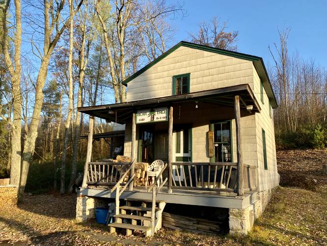
Bear Tree Camp (Private 99-year Lease Cabin) - Mile 0.6
At mile 0.6, as the service road curves west around the bend, hikers will find a 99-year lease cabin that may likely be the most remote private camp in all of Tioga State Forest. The cabin is named "Bear Tree Camp 16-C-108". This private camp is not open to the public, but since it's on public land, anyone can walk by. Just behind the cabin is a small trail that leads uphill. To find it, simply walk to the left-hand side of Bear Tree Camp and head straight back to find the trail heading uphill. This trail is an unofficial, unblazed, and seldomly-maintained trail.
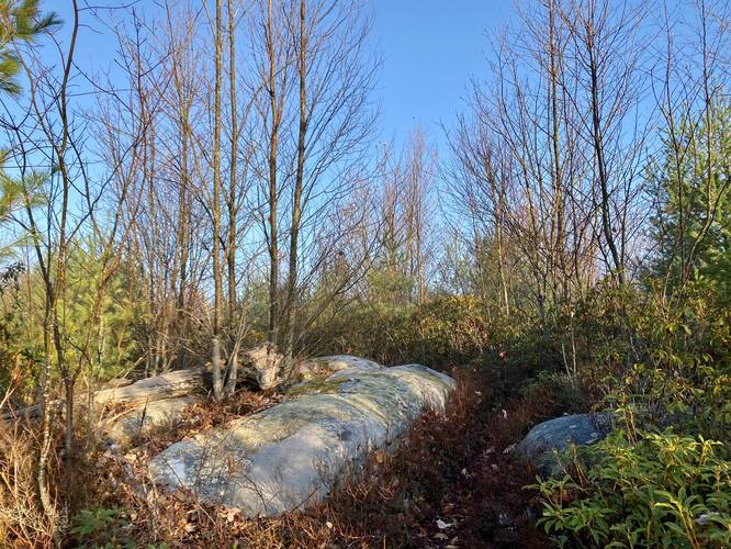
Bubble Rock - Mile 0.7
After hopping on the trail that heads uphill behind Bear Tree Camp, hikers will pass a rocky outcropping on the trail, nicknamed "Bubble Rock" due to its bubbly shape.
Left-Hand Turn - Mile 0.73
Just after passing Bubble Rock, hikers will take a left-hand turn along another unofficial, unblazed, and unmaintained trail. This turn is tricky and could get hikers lost on their way out, if they miss it, so please note it or use offline mapping tools to help navigate.
Obstructed View / Boulder - Mile 0.94
At mile 0.94 just off-trail from the unofficial trail is a rocky outcropping of a very large boulder ledge that sits on the side of the mountain. During colder months, hikers can get a nice, but obstructed view, from this rock. The boulder is about 8-feet tall and 12-feet wide with a slight overhang where a large tree has rooted underneath.
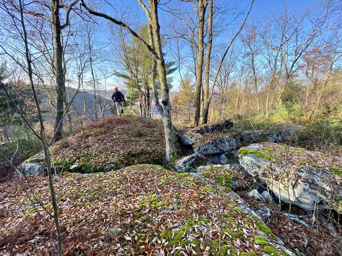
Bear Rocks - Mile 1
At mile 1, hikers will pass through a large rocky outcropping, nicknamed Bear Rocks, which is an interesting sight along the trail.
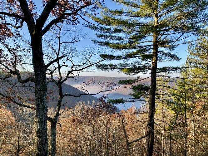
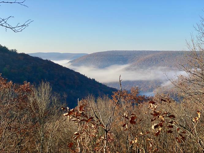
Bear Rocks Vista - Mile 1.1
Just beyond Bear Rocks lies the Bear Rocks Vista, around mile 1.1 located just off-trail. Bear Rocks Vista provides hikers with a view overlooking the Cedar Run canyon with views that peer into the PA Grand Canyon further downstream.
Hiking Out
Note that the hike out can be tricky if you aren't paying attention to the easy-to-miss right-hand turn located near Bubble Rock. It's best to bring an offline mapping tool in order to aid in navigation.
Seasonal Access (Cold Temps Recommended)
Please note that this particular hike and parking lot are only accessible after the snow has melted - usually in late April - and before the snow and ice build up - usually before December each year. Also note that the views are better with the leaves off the trees and is best to hike when it's cold outside to prevent stepping on Rattlesnakes as these rocky outcroppings are likely home to the Timber Rattlesnake.
Parking
Hikers will find a large parking lot at the coordinates provided. Please note that Old Mountain Road is a very long dirt road that's used primarily by hunters, large logging trucks, and forestry personnel, which means that unless the road has been recently graded and fixed, sometimes this road is literally impassible without a 4-wheel drive vehicle with high clearance (preferably a truck). As of November, 2022, this road is perfectly fine to travel without a vehicle with a high clearance; however, that's not always the case. An alternative parking lot can be found along PA-414 which requires a 1-mile, 1,000-foot hike up to the top of the mountain via the Bull Run Trail - hikers can find directions to that parking lot and the hike described on our Chimney Rock Vista Hike guide. Drive at your own risk.
Warning
Timber Rattlesnake: The Timber Rattlesnake calls this area home and is generally out roaming the forest between late April and early October. Due to the rocky outcroppings and thick forest setting, it's very likely that these rocks provide dens and shelter for these snakes. It's best to hike this trail when it's cold to try and avoid them. If you find a rattlesnake, please give it plenty of space.
Difficult Navigation: Note that there's at least one turn on the unmaintained/unofficial trail that could potentially lead hikers to getting lost, located near Bubble Rock. It's best to bring an offline mapping tool in order to make sure you do not get lost. One wrong turn may send you meandering around the woods for a long period of time.
Smile, You're On Camera: Bear Tree Camp is private and all hikers must respect the land owner's building and their privacy; however, that does not mean you aren't being watched if the land owners aren't around. There are several trail cameras around the private camp. I note this so folks are aware and to reinforce that you should never tamper with or enter a private residence without their permission. Please leave the private property alone.
Parking: Please read the parking notes before you head out.
Hunting: Hunting is allowed here so it's smart to wear blaze orange during hunting season.
History - Bull Run Fire
Hikers may notice charred trees and other signs of forest fires along this hike like open forest spaces and low growing bushes and trees. The low-growth mountain laurel, blueberry bushes, and young forests are all the result of the 2008 wildfire named the Bull Run Fire. Copied from the Tioga State Forest PDF: "In April 2008 a fire called the Bull Run Fire started on Rt. 414 south of Blackwell and raced up Bull Run Hollow. It burned for a week, traveling 2.5 miles, devastating almost 4000 forested acres. Approximately 150 fire fighters battled the blaze. Air tankers helped the fire fighters contain the massive fire that had flames at times as high as 35 feet. After the fire, large scale logging efforts took place to salvage usable wood products. Today a new forest is growing rapidly, but you can still see the charred remains of what was once there. Use caution and be aware of dead trees!"
Hike Description
This hike begins at the seasonal parking lot at the coordinates provided and heads north, passing the yellow service road gate. Hikers will follow the road, which has red blazes, all the way to the end where it becomes a dead-end at a private camp. Along the way down the road, hikers will get some partial views of the mountain top you'll be walking out onto, just north of Straight Run.
Bear Tree Camp (Private 99-year Lease Cabin) - Mile 0.6
At mile 0.6, as the service road curves west around the bend, hikers will find a 99-year lease cabin that may likely be the most remote private camp in all of Tioga State Forest. The cabin is named "Bear Tree Camp 16-C-108". This private camp is not open to the public, but since it's on public land, anyone can walk by. Just behind the cabin is a small trail that leads uphill. To find it, simply walk to the left-hand side of Bear Tree Camp and head straight back to find the trail heading uphill. This trail is an unofficial, unblazed, and seldomly-maintained trail.
Bubble Rock - Mile 0.7
After hopping on the trail that heads uphill behind Bear Tree Camp, hikers will pass a rocky outcropping on the trail, nicknamed "Bubble Rock" due to its bubbly shape.
Left-Hand Turn - Mile 0.73
Just after passing Bubble Rock, hikers will take a left-hand turn along another unofficial, unblazed, and unmaintained trail. This turn is tricky and could get hikers lost on their way out, if they miss it, so please note it or use offline mapping tools to help navigate.
Obstructed View / Boulder - Mile 0.94
At mile 0.94 just off-trail from the unofficial trail is a rocky outcropping of a very large boulder ledge that sits on the side of the mountain. During colder months, hikers can get a nice, but obstructed view, from this rock. The boulder is about 8-feet tall and 12-feet wide with a slight overhang where a large tree has rooted underneath.
Bear Rocks - Mile 1
At mile 1, hikers will pass through a large rocky outcropping, nicknamed Bear Rocks, which is an interesting sight along the trail.
Bear Rocks Vista - Mile 1.1
Just beyond Bear Rocks lies the Bear Rocks Vista, around mile 1.1 located just off-trail. Bear Rocks Vista provides hikers with a view overlooking the Cedar Run canyon with views that peer into the PA Grand Canyon further downstream.
Hiking Out
Note that the hike out can be tricky if you aren't paying attention to the easy-to-miss right-hand turn located near Bubble Rock. It's best to bring an offline mapping tool in order to aid in navigation.
Seasonal Access (Cold Temps Recommended)
Please note that this particular hike and parking lot are only accessible after the snow has melted - usually in late April - and before the snow and ice build up - usually before December each year. Also note that the views are better with the leaves off the trees and is best to hike when it's cold outside to prevent stepping on Rattlesnakes as these rocky outcroppings are likely home to the Timber Rattlesnake.
Parking
Hikers will find a large parking lot at the coordinates provided. Please note that Old Mountain Road is a very long dirt road that's used primarily by hunters, large logging trucks, and forestry personnel, which means that unless the road has been recently graded and fixed, sometimes this road is literally impassible without a 4-wheel drive vehicle with high clearance (preferably a truck). As of November, 2022, this road is perfectly fine to travel without a vehicle with a high clearance; however, that's not always the case. An alternative parking lot can be found along PA-414 which requires a 1-mile, 1,000-foot hike up to the top of the mountain via the Bull Run Trail - hikers can find directions to that parking lot and the hike described on our Chimney Rock Vista Hike guide. Drive at your own risk.
Warning
Timber Rattlesnake: The Timber Rattlesnake calls this area home and is generally out roaming the forest between late April and early October. Due to the rocky outcroppings and thick forest setting, it's very likely that these rocks provide dens and shelter for these snakes. It's best to hike this trail when it's cold to try and avoid them. If you find a rattlesnake, please give it plenty of space.
Difficult Navigation: Note that there's at least one turn on the unmaintained/unofficial trail that could potentially lead hikers to getting lost, located near Bubble Rock. It's best to bring an offline mapping tool in order to make sure you do not get lost. One wrong turn may send you meandering around the woods for a long period of time.
Smile, You're On Camera: Bear Tree Camp is private and all hikers must respect the land owner's building and their privacy; however, that does not mean you aren't being watched if the land owners aren't around. There are several trail cameras around the private camp. I note this so folks are aware and to reinforce that you should never tamper with or enter a private residence without their permission. Please leave the private property alone.
Parking: Please read the parking notes before you head out.
Hunting: Hunting is allowed here so it's smart to wear blaze orange during hunting season.
History - Bull Run Fire
Hikers may notice charred trees and other signs of forest fires along this hike like open forest spaces and low growing bushes and trees. The low-growth mountain laurel, blueberry bushes, and young forests are all the result of the 2008 wildfire named the Bull Run Fire. Copied from the Tioga State Forest PDF: "In April 2008 a fire called the Bull Run Fire started on Rt. 414 south of Blackwell and raced up Bull Run Hollow. It burned for a week, traveling 2.5 miles, devastating almost 4000 forested acres. Approximately 150 fire fighters battled the blaze. Air tankers helped the fire fighters contain the massive fire that had flames at times as high as 35 feet. After the fire, large scale logging efforts took place to salvage usable wood products. Today a new forest is growing rapidly, but you can still see the charred remains of what was once there. Use caution and be aware of dead trees!"