Loading...

🔥 End of Summer sale! 50% off on Supporter Accounts — now through September 1st. Learn More.

Bear Church Rock Hike

Directions
Map
Pictures
Send to App
Distance:
7.9 Miles / 12.7 km
Type:
Out-and-Back
Difficulty:
Moderate
Time to Hike:
3 hours, ~57 minutes
Features:
Surface Type:
Dirt
Park:
Shenandoah National Park
Town:
Graves Mill, Virginia
Directions:
38.43695, -78.367103
Added:
March 18, 2025
Updated:
April 05, 2025
Guide by:
Copy Trail Link Hiking this trail? Send a friend or family member a link to this trail guide for your own safety. Hike at your own risk (disclaimer)
Loading...
Loading...
1,946'

Total Change
2,241'

Ascent
2,234'

Descent

Download the Trail Route for Offline Use

Supporters get exclusive access to download trail routes to the MyHikes app for offline use. Stay prepared on your adventure, even without an internet connection! Become a Supporter today to unlock this feature and hike with confidence.

Send to App

Bear Church Rock Hike

Unlike many of the other picturesque hikes in the Shenandoah National Park, the Bear Church Rock circuit is not nearly as well known. This hike starts along the beautiful Rapidan River, then heads up alongside Staunton River with small falls and pools, before making a steep climb to the panoramic outcropping of views at Bear Church Rock.

The hike posted here also does a short 0.6 mile out and back detour to the magnificent Jones Mountain Cabin. The cabin sits next to a stream that runs most times of the year, and is maintained and available for rent from the Potomac Appalachian Trail Club.

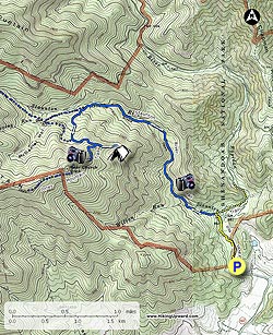
From the Graves Mill parking area on VA662 start up the yellow blazed Graves Mill Trail as is stays on the left of the Rapidan River for 0.5 miles to the intersection of the Staunton River Trail.

Turn left on the blue blazed Staunton River Trail, and in 0.5 miles look for a small side trail to a set of falls and pool. Continue along the Staunton River Trail another 1.7 miles to the intersection of the Jones Mountain Trail. Turn left on the steeper Jones Mountain Trail for 0.5 miles to the next junction, where the Jones Mountain Trail turns left, and the McDaniel Hollow Trail turns right.

Turn left staying on the Jones Mountain Trail as it winds around the mountain and passes through a canopy of Mountain Laurel before reaching an intersection where a side trail leads down to the Jones Mountain Cabin. The side trip to the cabin is 0.6 miles out and back, and well worth the extra distance.

After returning from the side hike to the cabin turn left uphill on the Jones Mountain Trail as it heads around the eastern side of the ridge for another 0.5 miles to the Bear Church Rock rock overlook. The Jones Mountain Trail continues past Bear Church Rock, so make sure not to miss the unmarked short side trail to Bear Church Rock on the right.

From high point of the hike retrace your steps back down Jones Mountain to the starting point and parking area.
Explore 68 trails near Graves Mill, VA
  1. Parking

    38.43695, -78.367103
  2. Main Trailhead

    38.437195, -78.367195
No community routes found. To add your own hike as a Community Route for this Trail guide, leave a Trip Report with an attached GPX file.

Hazards

Ticks - Lyme Disease More Info (CDC)
Snakes
Poison Ivy/Oak

Seasons

All

Trip Reports (Reviews)

Rated 4.42 out of 5 based on 79 ratings.
By: Ash
7.9 miles / 12.7 km
October 23, 2019
I also went mid-week and had the trail to myself expect for the last tenth of a mile coming back to the parking lot. I really enjoyed the variation in this hike. I've done this hike before and will do it again, probably in winter when the snow is covering everything.
Legacy Review
By: Robert
7.9 miles / 12.7 km
October 02, 2019
What a great hike! Nothing hard about this except the elevation change. Had the trail entirely to myself for this mid-week hike. Much of the trail is dirt or gravelly a lot easier on the ankles than a lot of trails in the park. As many have pointed out, the first part of the hike follows streams with regular turnoffs and things to look at and great pools to dip your tired feet into on the way back. The water is chilly! Things get a bit steeper past the stream, but nothing like white oak canyon. No scrambling at all, and the trail is extremely well maintained. The GPX file provided here stops short of the summit turnoff by at least a few hundred feet just keep going and look for the side trail turning off to the right. I started exploring the Graves Mountain trail a little further past Bear Church Rock but there was a large nest of ground bees swarming, in the middle of the trail just past the turn around the large rock outcropping, so I turned back.
Legacy Review
By: Cathy
7.9 miles / 12.7 km
September 21, 2019
Beautiful hike- rocks and streams are spectacular. As challenging as Old Rag with little to no crowds. View at the top is gorgeous.
Legacy Review

Weather Forecast

In Graves Mill, VA

Explore Hiking Trails

You May Also Like

New York's Best Waterfalls - Whether you're planning a day hike, roadside stop, or a leisurely short walk, this guide provides hikers, travelers, and locals alike with 63 different locations to over 100 scenic waterfalls to help plan your next adventure!
Explore

New York's Best Waterfalls

Whether you're planning a day hike, roadside stop, or a leisurely short walk, this guide provides hikers, travelers, and locals alike with 63 different locations to over 100 scenic waterfalls to help plan your next adventure!

Read
25 Best Day Hikes in North Carolina - Discover the top 25 best day hikes in North Carolina, from breathtaking waterfalls to mountain peaks. Explore hidden gems, scenic views, and trails suitable for all skill levels, perfect for your next outdoor adventure.
Explore

25 Best Day Hikes in North Carolina

Discover the top 25 best day hikes in North Carolina, from breathtaking waterfalls to mountain peaks. Explore hidden gems, scenic views, and trails suitable for all skill levels, perfect for your next outdoor adventure.

Read

Before you boogie...

Find our trail guides useful? Consider becoming a Supporter to unlock perks!

MyHikes is an indie platform that makes exploring public trails easier for everyone. The platform has no investors, no ads, and is owned and operated by one person, Dave Miller. Dave has personally mapped and written over 1,800 trail guides on MyHikes for the public to explore. MyHikes has helped millions outdoor enthusiasts plan their next adventure.

But it takes a lot of time 🕦, money 💰, work, and espresso shots ☕ to run MyHikes, including hiking , mapping , writing , and publishing new trails with high-quality (accurate) information... along with software engineering (coding) the platform like building new features, website and mobile app development (iOS and Android), site maintainance . and much much more.

Supporters unlock website and mobile app perks with an annual one-time payment of $25 (you renew) 😎👍. Or you can simply make a Donation of your choice. Otherwise, you can support us by telling your friends about MyHikes - both quick and free 🎉

Admin user profile picture

Dave Miller
MyHikes Founder