If you're looking for a hike with few people, historical artifacts, water, and more water, then try the Basin Creek Trail in Doughton Park. Doughton Park is a treasure trove of barely used trails in the northwest corner of North Carolina. This is the largest park operated by the Blue Ridge Parkway, and has over 30 miles of trails along creeks and open ridges. Starting at the base of the park on Longbottom Road, there are 5 hiking trails to choose from. Four of these involve steep climbs to the open fields and peaks on the western border of Doughton Park along the Blue Ridge Parkway. The 5th trail, Basin Creek, takes you deep into a secluded gorge. The Basin Creek Trail follows the path many people took 150 years ago to the Basin Cove community. In 1916 a flood roared through the valley wiping out the community except for Caudill Cabin, which stands at the end of the trail. Along the way you'll pass by 2 waterfalls, see historical remnants of the Basin Cove community, and cross many streams 16 times. Usually the highlight of a hike is a waterfall or summit viewpoint, but the end of this trail at the intact and restored Caudill Cabin in a clearing in the middle of nowhere feels remarkable.
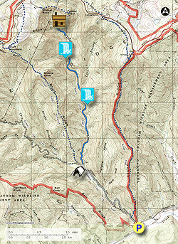
The park is accessed by taking Traphill Road off of U.S. 21 near Roaring Gap. Once you pass the main entrance to Stone Mountain State Park, continue a mile beyond and take a right on Longbottom Road. After 8 winding miles, the road rounds a bend and crosses Basin Creek. Directly before the bridge there is a large gravel parking area on the left. The park boundary and trails are immediately across the street.
- Mile 0.0 – From the parking area cross Longbottom Road and the Grassy Gap Fire Road (no blaze) continues on the other side. A sign for Doughton Park beside a gate is visible.
- Mile 0.1 – Junction with the Cedar Ridge Trail, stay straight on fire road which gently follows Basin Creek for 1.5 miles.
- Mile 1.1 – Step over a tributary stream that flows from a hanging valley.
- Mile 1.7 – First crossing over Basin Creek on a large wooden bridge. On the other side of the creek is Basin Cove, an excellent primitive camp site. This is the only backcountry camping allowed in Doughton Park. Enormous old-growth pine trees tower above.
- Mile 1.8 – At a T-junction the Grassy Gap Trail turns left, stay straight on the Basin Creek Trail (orange and blue blazes). Immediately climb above Basin Creek on a steep slope through a large swath of rosebay rhododendron.
- Mile 2.4 – On the left side of trail is the first intact chimney remnant from the Caudill community. Just past the chimney look for a mill grindstone lying in Basin Creek, a remnant of a grist mill washed away in the flood of 1916.
- Mile 2.6 –2nd crossing, first rock hop over Basin Creek. There are 15 rock hop crossings over Basin Creek and side streams along the Basin Creek Trail. The orange blazes are few and far between but are prominent near all creek crossings. Note: All of the crossings are rock hops on sometimes slick rocks. If the water is high you will get wet. There are still possibilities of getting wet during normal levels but it is manageable. Trekking poles or water shoes are highly recommended.
- Mile 3.0 – 3rd crossing over Basin Creek.
- Mile 3.1 – 4th crossing over Basin Creek.
- Mile 3.2 – 5th crossing over Basin Creek.
- Mile 3.3 – At the 3rd creek crossing the trail climbs high above Basin Creek, which drops into a narrow gorge. While you climb above the creek a waterfall is clearly visible below at the head of the gorge. There is no trail to the base of this waterfall, but access is fairly easy if you leave the trail at the creek crossing and stay in the creek and in the woods on river left. You will reach the base of the waterfall in approximately 500 feet. (The mileage for this hike does not incorporate the side trip to this waterfall.) At the moment there is no official name for this waterfall, so you may see it called Lower Falls on Basin Creek or Waterfall #1 on Basin Creek. Despite lacking a name this ~25-foot waterfall is beautiful. At the top of the falls the creek runs through a narrow chute then fans out over two drops. If you decided to visit the waterfall, retrace your steps down the creek to the trail crossing. It is steep and overgrown around the waterfall so scrambling out is not recommended.
- Mile 3.4 – 6th crossing over Basin Creek.
- Mile 3.5 – 7th crossing over Caudill Branch.
- Mile 3.6 – After crossing Caudill Branch, the second site of chimney remnants is on a short side trail on the right. There are two small chimneys here.
- Mile 3.9 – 8th crossing over Basin Creek.
- Mile 4.0 – Third chimney remnant found on left side of trail. Shortly after is the 9th crossing over Basin Creek.
- Mile 4.1 – 10th crossing over Basin Creek. For the next 0.3-mi the trail rises above the creek again and passes through a section of stinging nettles. The creek drops into a small gorge that isn't visible from the trail.
- Mile 4.4 – 11th crossing over tributary to Basin Creek. On the other side of the crossing is the fourth chimney remnant beside the trail.
- Mile 4.5 – 12th crossing over Basin Creek.
- Mile 4.6 –The trail crosses a rock ledge overlooking Middle Falls on Basin Creek (also known as Waterfall #2 on Basin Creek). This is a beautiful 2-tiered drop ~20 feet on the left side of the trail. The rock outcrop on the trail provides the best open view of the waterfall. You can scramble down the bank to the base of the waterfall for different angles and to relax, but the bank is steep and muddy. Beyond the waterfall the trail is much less-trafficked and overgrown with weeds and stinging nettles.
- Mile 4.8 – 13th crossing over Basin Creek.
- Mile 5.1 – 14th crossing over Basin Creek.
- Mile 5.15 – 15th crossing over Wildcat Branch. The trail leaves Basin Creek and follows Wildcat Branch the rest of the way to the cabin.
- Mile 5.2 – 16th crossing over Wildcat Branch. The trail passes through an older forest.
- Mile 5.5 – Reach the end of the trail at Caudill Cabin. The cabin sits in a clearing on a hill above Wildcat Branch almost 1000 feet below the Wildcat Rocks Overlook off the Blue Ridge Parkway. From here it is difficult to see Wildcat Rocks. This cabin is the only intact structure remaining from the devastating flood in 1916 which swept through the Basin Creek valley wiping out the community. You can go inside the cabin and read the family tree that contains old photographs of the cabin.
- Mile 9.4 – Retrace your steps back down Basin Creek, and the Grassy Gap fire road to end the hike back at the Longbottom Road parking area.