Loading...

🍁 Fall is here! Check out our foliage map to plan your autumn hikes! Learn more.

Balls Bluff Battlefield Hike

Directions
Map
Pictures
Send to App
Distance:
2.2 Miles / 3.5 km
Type:
Loop
Difficulty:
Easy
Time to Hike:
1 hour, ~6 minutes
Features:
Surface Type:
Dirt
Town:
Leesburg, Virginia
Get Directions:
39.130549, -77.530797
Added:
April 03, 2025
Updated:
April 06, 2025
Guide by:
Copy Trail Link Hiking this trail? Send a friend or family member a link to this trail guide for your own safety. Hike at your own risk (disclaimer)
Loading...
Loading...
121'

Total Change
347'

Ascent
343'

Descent

Download the Trail Route for Offline Use

Supporters get exclusive access to download trail routes to the MyHikes app for offline use. Stay prepared on your adventure, even without an internet connection! Become a Supporter today to unlock this feature and hike with confidence.

Send to App

Key Takeaways

  • The Balls Bluff Battlefield Regional Park in Leesburg, VA, offers a 2.2-mile hike through a historically significant Civil War site.
  • The park features notable landmarks such as the National Cemetery, Potomac River views, sandstone bluffs, and informational signage detailing the Battle of Balls Bluff.
  • Navigating the park's multiple trails is best accomplished with a printed trail map provided by the NVRPA.

Balls Bluff Battlefield Hike

Located in the heart of Loudoun County between the Potomac River and Leesburg VA, the Balls Bluff Battlefield Regional Park was the location of a battle that effected the course of the Civil War. There are many things to see in the park including the National Cemetery, Potomac River, and views from the sandstone shale bluffs. Make sure to print the trail map provided by the NVRPA as there are so many trails to explore having a trail map with you will make it a lot easier to navigate the park.

Battle of Balls Bluff - October 21, 1861

Early on the day of October 21, 1861 a Union raiding party from the 15th Massachusetts advanced on a presumed Confederate camp based on information provided by a patrol the previous night. This information was inaccurate, and the camp was actually a tree line misidentified as tents in the low light. Company K of the 15th Mississippi advanced from the southwest and clashed with the Union troops shortly thereafter. The Union army was then hampered by the slow arrival of reinforcements caused by too few boats able to transport troops across the river.

The battle turned into a rout of the Union when more reinforcements from the Confederate's Virginia Cavalry and Virginia 8th Infantry arrived by 12:30p.m. The now 700 strong Confederate soldiers attacked the 650 Union troops who then retreated back to the southern point on the bluff. At this time some of the fiercest fighting occurred, with 236 Union soldiers killed and 553 captured, and 36 Confederate soldiers killed with 3 captured.

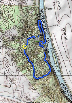
Battle of Balls Bluff Troop Movement Map

  • National Cemetery - View of the Cemetery 50 yards from Balls Bluff
  • Main Battlefield - 360 degree view of the main battlefield
  • Balls Bluff Overlook - Obstructed vista towards Harrison Island on the Potomac River
  • Potomac Heritage Trail - View of the Potomac River from the trail
  • Southern Overlook - View from the Potomac Heritage Trail from the southern bluff in the park
  • Cannon - Replica cannon used by the Federal Troops
  • Battlefield Information - Excellent signage throughout the park with information about the battle
  • Picnic Area - Picnic area along the blue trail with playground
  • Balls Bluff - Views of Balls Bluff from the Potomac Heritage Trail the Federal Troops would have encountered in 1861
Explore 39 trails near Leesburg, VA
  1. Parking

    39.130549, -77.530797
  2. Main Trailhead

    39.13046, -77.531033
No community routes found. To add your own hike as a Community Route for this Trail guide, leave a Trip Report with an attached GPX file.

Hazards

Ticks - Lyme Disease More Info (CDC)
Poison Ivy/Oak

Seasons

All

Photo Albums

+ Add Photo Album

Upload your photos from the trail to help others know what to expect.

Preview of the MyHikes mobile app interface

Track, Log, and Explore Hikes with the MyHikes App

Explore Autumn Foliage

No Change
Some Color
Low Color
Moderate Color
High Color
Peak Color
Past Peak
Sept 1 Sept 8 Sept 15 Sept 22 Sept 29 Oct 6 Oct 13 Oct 20 Oct 27 Nov 3 Nov 10 Nov 17 Nov 24

Trip Reports (Reviews)

Ready to help fellow hikers? Add a trip report to share your experience and provide valuable insights for those planning their next hike. Your review makes the trail better for everyone.

Rated 3.0 out of 5 based on 2 ratings.
By: Tom
2.2 miles / 3.5 km
March 17, 2017
Recommended more than the "3" implies. We didn't do the trail as described. We started at the south end of the park (Edwards Landing Park) hiked up close to the northern edge, and back - about 4.6 miles - a full loop with only 50 yards on the same path we came. A very pleasant hike. The trail climbs up and down a number of ravines to give some nice variety and some workout. The winter trees provided good views of the Potomac, and the Civil War battleground and cemetery have lots of informative signs with an incredible amount of detail. Definitely bring a copy of the trail map - there are so many trails and intersections that wrong turns are likely, but no big deal. The large number of crossing trails also make it easy to choose how long to walk - you can turn around at any number of places.
Legacy Review
By: Brian S
2.2 miles / 3.5 km
December 04, 2016
I have hiked this one a few times now in the last several months after living in Leesburg for over 15 years and not really know about it. Mostly wooded and quiet trails except around the cemetery. I have taken my dogs with me and they enjoy it too. There are usually a few other hikers and some dogs out for a walk but not very crowded. A couple of my visits it was a little muddy on the trail down by the Potomac and the hills to get down there can be slippery so be careful of your footing and bring something to clean the mud off the pups when you get back (lots of red clay.) Some up and down in ravines but nothing to serious. Nice little park with some interesting history markers to stop and read (cemetery is full of almost all Unknown soldiers).
Legacy Review

Weather Forecast

In Leesburg, VA

Explore Hiking Trails

You May Also Like

New York's Best Waterfalls - Whether you're planning a day hike, roadside stop, or a leisurely short walk, this guide provides hikers, travelers, and locals alike with 63 different locations to over 100 scenic waterfalls to help plan your next adventure!
Explore

New York's Best Waterfalls

Whether you're planning a day hike, roadside stop, or a leisurely short walk, this guide provides hikers, travelers, and locals alike with 63 different locations to over 100 scenic waterfalls to help plan your next adventure!

Read
25 Best Day Hikes in North Carolina - Discover the top 25 best day hikes in North Carolina, from breathtaking waterfalls to mountain peaks. Explore hidden gems, scenic views, and trails suitable for all skill levels, perfect for your next outdoor adventure.
Explore

25 Best Day Hikes in North Carolina

Discover the top 25 best day hikes in North Carolina, from breathtaking waterfalls to mountain peaks. Explore hidden gems, scenic views, and trails suitable for all skill levels, perfect for your next outdoor adventure.

Read

Before you boogie...

Find our trail guides useful? Consider becoming a Supporter to unlock perks!

MyHikes is an indie platform that makes exploring public trails easier for everyone. The platform has no investors, no ads, and is owned and operated by one person, Dave Miller. Dave has personally mapped and written over 1,800 trail guides on MyHikes for the public to explore. MyHikes has helped millions outdoor enthusiasts plan their next adventure.

But it takes a lot of time 🕦, money 💰, work, and espresso shots ☕ to run MyHikes, including hiking , mapping , writing , and publishing new trails with high-quality (accurate) information... along with software engineering (coding) the platform like building new features, website and mobile app development (iOS and Android), site maintainance . and much much more.

Supporters unlock website and mobile app perks with an annual one-time payment of $25 (you renew) 😎👍. Or you can simply make a Donation of your choice. Otherwise, you can support us by telling your friends about MyHikes - both quick and free 🎉

Admin user profile picture

Dave Miller
MyHikes Founder