Balanced Rock Vista Hike at Tiadaghton State Forest in Waterville, Pennsylvania is a strenuous 1.6-mile out-and-back bushwhack hike that leads to views of the PA Grand Canyon from an old mountainside quarry where the historic Balanced Rock still stands.
Trails
This hike does not follow any blazed or maintained trail, but rather follows a very old and abandoned quarry road. The quarry appears to be from the 1800's, so the pathway is wide enough for one horse or mule-drawn wagon.
Bushwhacking - Experienced Hikers Only
This hike is meant for the experienced bushwhack hiker and not the novice hiker. Also note that as of August, 2023 this hike requires a significant amount of bushwhacking through rocky terrain that might be home to the Timber Rattlesnake.
Hike Description
This hike begins along PA-44 at the parking coordinates provided in Waterville. Hikers will park just outside of a PennDOT station where a large parking lot can be found.
PA-44 to Creek Bed & Quarry Road - Mile 0 to 0.2
Hikers will walk down PA-44 for approximately 0.2-miles before reaching a steep and rocky creek bed on the north side of the road. Here, you'll scramble up this rocky creek bed to reach the old quarry road.
Quarry Road Hiking
Once on the quarry road, hikers will make their way up the very steep path as it traverses the side of the mountain to reach the old quarry. Along the way is at least one very large section of rock that appears to have been laid down on-purpose by the mining company over 100-years ago - this section of rock has many places where Timber Rattlesnakes can live or hide, so watch your steps.
1st Quarry / Red Ledge - Mile 0.5
Around mile 0.5, the trail will level-out as it reaches the "flat" and skinny quarry road that follows the mountain's contour. Here, you'll find 40-foot cliffs of red rock along with some neat bedrock "chimneys" that sit along the mountain's edge just off of the quarry road. Here, the hike becomes a lot more difficult as the quarry road has not been "maintained" in decades or even significantly longer. Starting here, to keep safe, hikers will want to make sure they do not hike down the mountain or up the mountain more than ~10-feet to stay on the quarry road as it's mostly-flat but very difficult to follow.
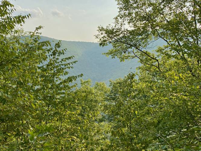
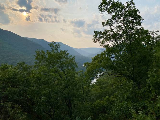
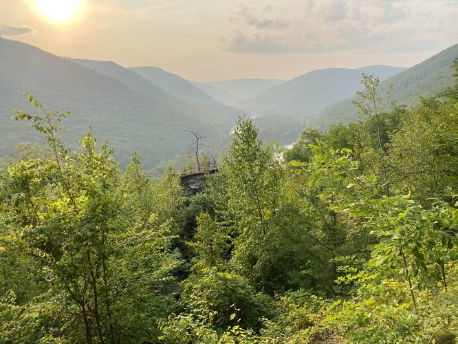
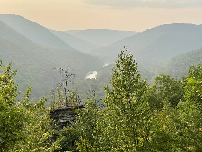
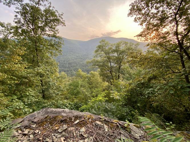
Cliff Vista - Mile 0.6
Around mile 0.6, hikers will find another series of ledges/cliffs that make their way up the mountain at about 40-feet tall in total. At the top is a nice view of the PA Grand Canyon; however, climbing up and down climbing this cliff is very very difficult and sketchy. Instead of exploring this cliff, enjoy the photos we took from the top.
Stump Rock - Mile 0.65
At mile 0.65 (in the data), hikers will find Stump Rock which is a miniature version of Balanced Rock. Stump Rock is about 7-feet tall from the quarry road, so it's easy to climb to the top to get a nice view of the PA Grand Canyon, albeit a bit obstructed in places.
Ledge Vista - Mile 0.66
Just beyond Stump Rock is another view, but located on a cliff ledge right on the quarry road.
After passing the Ledge Vista, hikers will be back on the quarry road - passing piles of stone that line the road. As stated before, the quarry road is skinny and with the overgrowth hikers will undulate around fallen rocks, rock piles, and skinny trees as they make their way toward Balanced Rock.
Open Quarry w/"Dead End" - Mile 0.7
Around mile 0.7, hikers will reach a very large and open quarry cut-out on the side of the mountain where the south-end of the quarry road seemingly "ends". This is where you know you're almost at Balanced Rock. If you hike through the overgrowth and bushwhack beyond this quarry cut-out, you'll find an animal path that passes through the trees. On the other side sits Balanced Rock!
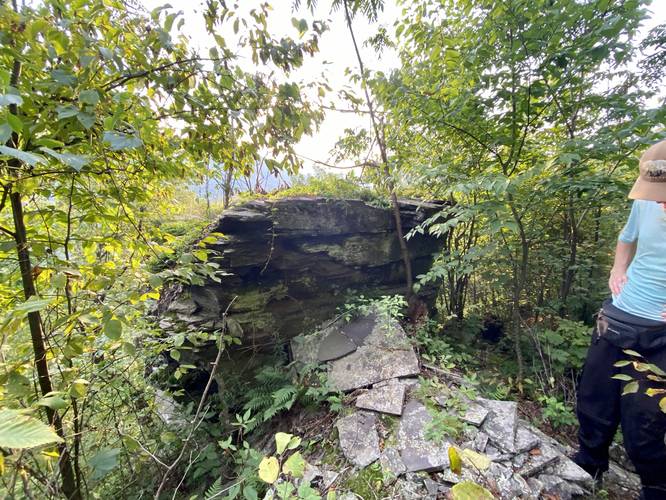
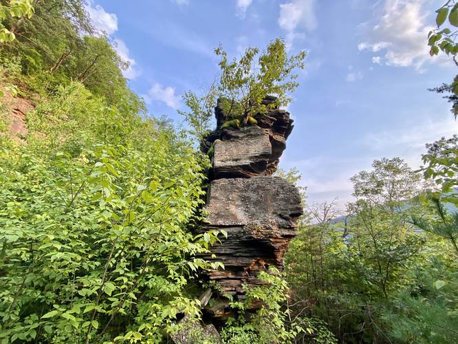
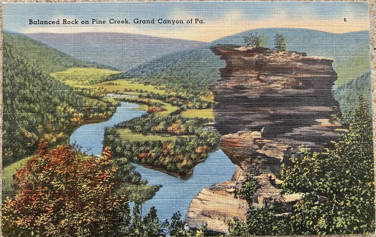
Balanced Rock - Mile 0.78
Around mile 0.78, after bushwhacking the last ~150-feet, hikers will reach the historic Balanced Rock. The goal for this hike was to locate Balanced Rock, and if possible, take a photo that's similar to an early-1900's postcard. Balanced Rock has several really interesting features - first, it's the tallest free-standing rock on the mountainside, it has several foot and handholds for rock climbers to test their strength, it has a port-hole or tunnel that passes through the middle forming a "window" in the rock, and last, it has a few sections of very-old moss that's built-up a thick carpet of green that clings to the stone pillar.
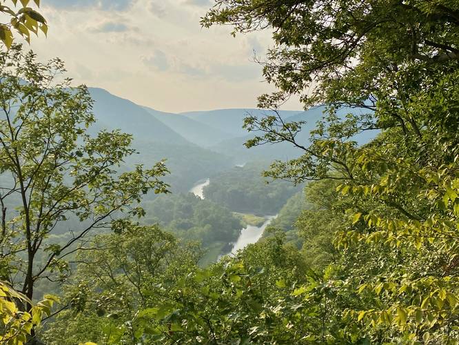
Balanced Rock Vista - Mile 0.8
Just behind Balanced Rock is another large quarry cut-out on the mountainside. Hikers, if very careful, can scramble up the shale scree field to reach the base of the 30-foot red rock cliff. From the cliff, hikers get a stunning view of the PA Grand Canyon with Balanced Rock below. 100+ years ago, Balanced Rock would have been visible without trees surrounding, but as of August, 2023 Balanced Rock juts out of the surrounding trees to make an appearance for the dedicated hiker that makes their way to the vista.
After exploring the rocks and taking in the views, the hike out is identical but opposite to the way in. Take your time hiking out and watch your step as there could be Timber Rattlesnakes along the old quarry road.
Parking
Hikers will find a medium-sized parking lot at the coordinates provided. The parking lot is technically a PennDOT station, so do not block the gate and do not block any of the rock/stone piles. Park at your own risk, however, towing here is likely rare.
Pets
Dogs are allowed but they should be leashed at all times to keep from running into rattlesnakes.
Warnings
Steep terrain: This hike follows very steep terrain as it leads up to the old mountainside quarry.
Timber Rattlesnakes: As stated many times, the Timber Rattlesnake lives in this area and quarries like these are great for rattlesnake dens. Watch your step and go very slowly to ensure your own safety.
Bushwhacking: This hike requires a lot of nasty bushwhacking, so this hike is meant for the experienced hiker.
Cliffs / Falling Rock: The old quarry road follows a mountain contour that's very very skinny - the road itself is very skinny and was built to facilitate a single wagon traversing the route. On one side of the quarry road are cliffs and ledges and on the other side are quarried bedrock cliffs. Watch your step, walk, and/or climb at your own risk.
No water: There's no water along this hike especially in the Summer.
Trails
This hike does not follow any blazed or maintained trail, but rather follows a very old and abandoned quarry road. The quarry appears to be from the 1800's, so the pathway is wide enough for one horse or mule-drawn wagon.
Bushwhacking - Experienced Hikers Only
This hike is meant for the experienced bushwhack hiker and not the novice hiker. Also note that as of August, 2023 this hike requires a significant amount of bushwhacking through rocky terrain that might be home to the Timber Rattlesnake.
Hike Description
This hike begins along PA-44 at the parking coordinates provided in Waterville. Hikers will park just outside of a PennDOT station where a large parking lot can be found.
PA-44 to Creek Bed & Quarry Road - Mile 0 to 0.2
Hikers will walk down PA-44 for approximately 0.2-miles before reaching a steep and rocky creek bed on the north side of the road. Here, you'll scramble up this rocky creek bed to reach the old quarry road.
Quarry Road Hiking
Once on the quarry road, hikers will make their way up the very steep path as it traverses the side of the mountain to reach the old quarry. Along the way is at least one very large section of rock that appears to have been laid down on-purpose by the mining company over 100-years ago - this section of rock has many places where Timber Rattlesnakes can live or hide, so watch your steps.
1st Quarry / Red Ledge - Mile 0.5
Around mile 0.5, the trail will level-out as it reaches the "flat" and skinny quarry road that follows the mountain's contour. Here, you'll find 40-foot cliffs of red rock along with some neat bedrock "chimneys" that sit along the mountain's edge just off of the quarry road. Here, the hike becomes a lot more difficult as the quarry road has not been "maintained" in decades or even significantly longer. Starting here, to keep safe, hikers will want to make sure they do not hike down the mountain or up the mountain more than ~10-feet to stay on the quarry road as it's mostly-flat but very difficult to follow.
Cliff Vista - Mile 0.6
Around mile 0.6, hikers will find another series of ledges/cliffs that make their way up the mountain at about 40-feet tall in total. At the top is a nice view of the PA Grand Canyon; however, climbing up and down climbing this cliff is very very difficult and sketchy. Instead of exploring this cliff, enjoy the photos we took from the top.
Stump Rock - Mile 0.65
At mile 0.65 (in the data), hikers will find Stump Rock which is a miniature version of Balanced Rock. Stump Rock is about 7-feet tall from the quarry road, so it's easy to climb to the top to get a nice view of the PA Grand Canyon, albeit a bit obstructed in places.
Ledge Vista - Mile 0.66
Just beyond Stump Rock is another view, but located on a cliff ledge right on the quarry road.
After passing the Ledge Vista, hikers will be back on the quarry road - passing piles of stone that line the road. As stated before, the quarry road is skinny and with the overgrowth hikers will undulate around fallen rocks, rock piles, and skinny trees as they make their way toward Balanced Rock.
Open Quarry w/"Dead End" - Mile 0.7
Around mile 0.7, hikers will reach a very large and open quarry cut-out on the side of the mountain where the south-end of the quarry road seemingly "ends". This is where you know you're almost at Balanced Rock. If you hike through the overgrowth and bushwhack beyond this quarry cut-out, you'll find an animal path that passes through the trees. On the other side sits Balanced Rock!
Balanced Rock - Mile 0.78
Around mile 0.78, after bushwhacking the last ~150-feet, hikers will reach the historic Balanced Rock. The goal for this hike was to locate Balanced Rock, and if possible, take a photo that's similar to an early-1900's postcard. Balanced Rock has several really interesting features - first, it's the tallest free-standing rock on the mountainside, it has several foot and handholds for rock climbers to test their strength, it has a port-hole or tunnel that passes through the middle forming a "window" in the rock, and last, it has a few sections of very-old moss that's built-up a thick carpet of green that clings to the stone pillar.
Balanced Rock Vista - Mile 0.8
Just behind Balanced Rock is another large quarry cut-out on the mountainside. Hikers, if very careful, can scramble up the shale scree field to reach the base of the 30-foot red rock cliff. From the cliff, hikers get a stunning view of the PA Grand Canyon with Balanced Rock below. 100+ years ago, Balanced Rock would have been visible without trees surrounding, but as of August, 2023 Balanced Rock juts out of the surrounding trees to make an appearance for the dedicated hiker that makes their way to the vista.
After exploring the rocks and taking in the views, the hike out is identical but opposite to the way in. Take your time hiking out and watch your step as there could be Timber Rattlesnakes along the old quarry road.
Parking
Hikers will find a medium-sized parking lot at the coordinates provided. The parking lot is technically a PennDOT station, so do not block the gate and do not block any of the rock/stone piles. Park at your own risk, however, towing here is likely rare.
Pets
Dogs are allowed but they should be leashed at all times to keep from running into rattlesnakes.
Warnings
Steep terrain: This hike follows very steep terrain as it leads up to the old mountainside quarry.
Timber Rattlesnakes: As stated many times, the Timber Rattlesnake lives in this area and quarries like these are great for rattlesnake dens. Watch your step and go very slowly to ensure your own safety.
Bushwhacking: This hike requires a lot of nasty bushwhacking, so this hike is meant for the experienced hiker.
Cliffs / Falling Rock: The old quarry road follows a mountain contour that's very very skinny - the road itself is very skinny and was built to facilitate a single wagon traversing the route. On one side of the quarry road are cliffs and ledges and on the other side are quarried bedrock cliffs. Watch your step, walk, and/or climb at your own risk.
No water: There's no water along this hike especially in the Summer.


