Loading...

WINTER SALE! 50% OFF Supporter Accounts — now through January 31st. Learn More.

Babel Tower Hike

Babel Tower is a popular destination in the Linville Gorge Wilderness and is one of the most heavily used official trails on the western side of the gorge. From Kistler Memorial Highway/Old NC 105, the trail descends through hardwoods and rhododendrons, descending 900 feet in 1.2 miles over rocky terrain. Babel Tower is a massive rock pinnacle rising over 400 feet above a giant horseshoe curve in the river. This impressive series of rock pulpits and cliffs serves as an unofficial dividing line between the snakelike north end of the gorge and the relatively straight southern course. The trail and the tower extend hundreds of yards north from the Linville Gorge Trail junction and is ripe for exploration. Many scramble paths lead to outstanding cliffside views south of Table Rock Mountain hovering above the gorge. After you are done exploring Babel Tower, you may want to check out the river too. Head west (trail direction north) on the Linville Gorge Trail, which drops down to a great little spot with a waterfall and massive swimming hole surrounded by sheer rock walls. Replete with huge, flat bedrock, it is the perfect location to cool off during the summer.

Wilderness Regulations – Group size in the wilderness is limited to 10 persons. A free camping permit is required on weekends and holidays May through October. Permits are first-come, first-serve. You can pick up a permit at the ranger office near Linville Falls, or contact the Grandfather Ranger District office to reserve one in advance. No large mechanical devices are allowed in the wilderness, such as aerial drones. Trails in the wilderness are not blazed and signs at trail intersections are infrequent.

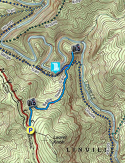
  • Mile 0.0 – Parking is available at the Babel Tower Trailhead beside Kistler Memorial Highway/Old NC 105. The Babel Tower Trail [240] (no blaze) heads north from the parking area through hardwood forests. Multiple campsites surround the first few hundred feet of the trail.
  • Mile 0.3 – The trail turns right away from a spring.
  • Mile 0.35 – Pass by a rock outcrop with open views of Linville Gorge. Across the gorge towards the southeast is Sitting Bear Mountain. You should be able to spot the rock formation known as the “Sitting Bear” on the right below the summit. The massive cluster of rocks towards the northeast above the river is Babel Tower. The trail descends moderately through hardwood forests mixed with azaleas and rhododendrons as you get closer to the bottom of the trail.
  • Mile 1.2 – The Babel Tower Trail continues straight through an angled cross intersection with the Linville Gorge Trail [231] (no blaze). The Babel Tower Trail dips to the right around a rock outcrop, passing through a campsite below the highest rock spires of Babel Tower. From here the trail stays on the left/west side of the highest points of Babel Tower. As you pass beneath rock overhangs, you should see occasional scramble trails leading up to the right. Look for the most obvious trail on the right that doesn’t involve scrambling, it leads to a campsite and overlook.
  • Mile 1.3 – Grassy campsite and cliff overlook from Babel Tower. The highest point of Babel Tower is immediately south but is only accessible by scrambling and climbing. This spot provides the best view southeast of Table Rock Mountain rising above Linville River. Back on the main trail, most people turn around here. However, the scramble trail continues north towards the tip of Babel Tower.
  • Mile 1.5 – The scramble trail ends near the northern tip of Babel Tower. You have a slightly different perspective south of the gorge, with many of the rock outcrops of Babel Tower on the right side of the view. Towards the southwest the highest point of Babel Tower is obscured by trees, and you can see the location of the parking area in a saddle between two ridges.
  • Mile 1.8 – If you would like to see the river, turn right on the Linville Gorge Trail [231] (no blaze) heading west (trail direction north). As you get close to the river, the condition of the trail gets progressively worse. Many blowdowns and deadfall have altered the course of the trail along this section.
  • Mile 2.0 – Turn right on a side trail that is typically marked with flagging tape. The descent from here is rough with huge boulders and large, slick blowdowns.
  • Mile 2.05 – The trail ends at a wide turn of Linville River. The river is funneled through a narrow chasm in the bedrock and drops over a ~10-foot cascade known as Babel Tower Falls. Downstream, sheer canyon walls rise above the river. A massive swimming hole lies at the base of the waterfall. This is a really nice area to take a break on the large bedrock beside the river. After you are done, turn around and hike back up towards Babel Tower.
  • Mile 2.4 – Turn right on the Babel Tower Trail.
  • Mile 3.1 – Hike ends at the Babel Tower Trailhead.
By HikingUpward Contributor: Zach Robbins
Explore 42 trails near Linville Gorge Wilderness, NC

Know Before You Go

  • Babel Tower Trail is a popular 3.1-mile hike in Linville Gorge Wilderness, NC, featuring a significant descent (900 feet in 1.2 miles) to a massive rock pinnacle with cliffside views.
  • The Babel Tower area offers opportunities for exploration, scrambling to overlooks, and views of Table Rock Mountain, with the Linville Gorge Trail providing access to Babel Tower Falls and a swimming hole.
  • Wilderness regulations include group size limits (10 persons) and permit requirements for camping on weekends/holidays (May-October); navigation can be challenging due to unmarked trails.
Interactive topographic map for Babel Tower Hike located in Linville Gorge Wilderness, NC. Click the "View Map" button to load GPS coordinates and trail markers.
Get directions
Distance
3.1 mi
Difficulty
Hard
Type
Out-and-Back
Est. Time
1.6 hrs
Elev. Gain
1,263'
Rating
4.0
Added
March 13, 2025
Updated
June 07, 2025

Weather Forecast

Tonight
Low 14°F
Slight Chance Rain And Snow then Partly Cloudy
Thursday
High 20°F
Sunny
Thursday Night
Low 12°F
Mostly Clear
Friday
High 36°F
Mostly Sunny
Friday Night
Low 25°F
Mostly Cloudy then Chance Snow Showers
Saturday
High 38°F
Chance Snow Showers
Saturday Night
Low 16°F
Partly Cloudy then Slight Chance Snow Showers
Sunday
High 23°F
Slight Chance Snow Showers then Mostly Sunny
Sunday Night
Low 12°F
Mostly Clear
M.L. King Jr. Day
High 32°F
Sunny
Monday Night
Low 12°F
Mostly Clear
Tuesday
High 28°F
Sunny
Tuesday Night
Low 14°F
Mostly Clear
Wednesday
High 38°F
Mostly Sunny
Loading...
Total Change
1,081'
Ascent
1,263'
Descent
1,270'
Loading...

Download the GPX Data for Offline Use

Supporters get exclusive access to download trail routes to the MyHikes app for offline use. Stay prepared on your adventure, even without an internet connection! Become a Supporter today to unlock this feature and hike with confidence.

Download Babel Tower Hike GPX Data to the MyHikes Mobile App

Features

Vista / Lookout Point
Dogs
Waterfalls
Camping
Water Source

Points of interest

  1. Parking

    35.918555, -81.919556
  2. Main Trailhead

    35.918555, -81.919556

Safety information

For your own safety: plan ahead, let someone know where you'll be, and hike at your own risk.

Hazards

Snakes (Rattlesnakes, Copperheads, others)
Poison Ivy or Poison Oak

Availability

All seasons

Surface type

Dirt

Trip Reports (Reviews)

Rated 4.0 out of 5 based on 1 rating.

Ready to help fellow hikers? Add a trip report to share your experience and provide valuable insights for other hikers!

By: Kyle
3.1 miles / 5.0 km
April 14, 2018
Wow, what a treat! Thank you to Zach for posting the info about this hike. The write up allowed me to navigate the trail without any issue. The only advice I would give is that, if using Google Maps to find the trail head, proceed about .25 miles past where Google Maps alleges the Babel Tower Trail head is. Be careful around the falls, the black moss on the rocks is incredibly slippery.
Legacy Review
No community routes found. To add your own hike as a Community Route for this Trail guide, leave a Trip Report with an attached GPX file.

Popular categories

Scenic mountain view representing vista trails
Vista trails
Scenic gorge of cascades representing waterfall trails
Waterfall hikes
Rugged mountain terrain representing summit trails
Summit trails
Scenic mountain view representing dog-friendly trails
Dog-friendly
Scenic campsite with a view representing camping trails
Camping trails
Appalachian Trail logo representing A.T. hikes
A.T. hikes

You May Also Like

25 Best Day Hikes in North Carolina - Discover the top 25 best day hikes in North Carolina, from breathtaking waterfalls to mountain peaks. Explore hidden gems, scenic views, and trails suitable for all skill levels, perfect for your next outdoor adventure.
Explore

25 Best Day Hikes in North Carolina

Discover the top 25 best day hikes in North Carolina, from breathtaking waterfalls to mountain peaks. Explore hidden gems, scenic views, and trails suitable for all skill levels, perfect for your next outdoor adventure.

Read
Colorado's Million Dollar Highway - Plan a day's drive adventure along the iconic Million Dollar Highway in Colorado. Explore the best short trails, roadside stops, waterfalls, vistas, ghost towns, and hot springs within a ~6 hour road trip.
Explore

Colorado's Million Dollar Highway

Plan a day's drive adventure along the iconic Million Dollar Highway in Colorado. Explore the best short trails, roadside stops, waterfalls, vistas, ghost towns, and hot springs within a ~6 hour road trip.

Read
Glacier's Going-to-the-Sun Road - Discover the breathtaking beauty of Glacier National Park along the iconic Going-to-the-Sun Road. From stunning roadside stops to picturesque waterfalls and vistas, this engineering marvel offers endless opportunities for exploration.
Explore

Glacier's Going-to-the-Sun Road

Discover the breathtaking beauty of Glacier National Park along the iconic Going-to-the-Sun Road. From stunning roadside stops to picturesque waterfalls and vistas, this engineering marvel offers endless opportunities for exploration.

Read
🍪 We use cookies to learn about site usage and to serve map tiles. You may block cookies manually in the browser. By continuing you agree. Learn more