Loading...

๐ŸŽ† 50% off 4th of July sale on Supporter Accounts โ€” now through July 6! Learn More.

Aunt Sarah's Falls

Directions
Map
Pictures
Send to App
Distance:
0.1 Miles / 0.2 km
Type:
Out-and-Back
Difficulty:
Easy
Time to Hike:
~5 minutes
Features:
Surface Type:
Dirt
Town:
Montour Falls, New York
Directions:
42.352381, -76.855503
Added:
January 25, 2021
Updated:
March 05, 2021
Copy Trail Link Hiking this trail? Send a friend or family member a link to this trail guide for your own safety. Hike at your own risk (disclaimer)
Loading...
Loading...
0'

Total Change
0'

Ascent
0'

Descent

Download the Trail Route for Offline Use

Supporters get exclusive access to download trail routes to the MyHikes app for offline use. Stay prepared on your adventure, even without an internet connection! Become a Supporter today to unlock this feature and hike with confidence.

Send to App

Aunt Sarah's Falls

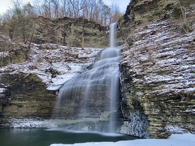
Aunt Sarah's Falls in Montour Falls, New York is an easy 0.1 mile walk to a large 90-foot tall fantail waterfall, named Sarah's Falls. The waterfall cascades down a slate hill gorge alongside NY-14 where visitors can get a great view of the waterfall without leaving their cars if they wish.

There is no real trail here, but the GPS recording provided leads from the parking area, to the base of Sarah's Falls, and back. The view from the parking lot is probably better than from the base of Sarah's Falls, but that's just my opinion. Note that the waterfall, for obvious reasons, is mostly dried up during the Summer.

Other Waterfalls in Town
There are plenty of waterfalls close-by that usually flow year-round with more water than this one, like Deckertown Falls or Shequaga Falls - both in Montour Falls, NY.

Parking
Visitors will find parking at the coordinates provided. The lot is large enough to fit a couple dozen vehicles.

Pets
Dogs are allowed if leashed.

Warning
Crossing NY-14 is not easy, be careful. Also note that the view from the parking lot is better than the view from the base of the waterfall, generally speaking.
Explore 92 trails near Montour Falls, NY
  1. Parking

    42.352381, -76.855503
  2. Main Trailhead

    42.352292, -76.855577
  3. Aunt Sarah's Falls (90-ft tall)

    42.352006, -76.855819
    Aunt Sarah's Falls (90-ft tall)
No community routes found. To add your own hike as a Community Route for this Trail guide, leave a Trip Report with an attached GPX file.

Hazards

Ticks - Lyme Disease More Info (CDC)

Seasons

All

Trip Reports

Trail Guide By:
Admin user profile picture
0.1 miles / 0.2 km
0.1 miles / 0.2 km
January 14, 2024
Dogs Hiking
0.1 miles / 0.2 km
January 14, 2024
Finally got to see Aunt Sarah's Falls in all of its glory during a heavy Winter snow squall. Showed up right as the snow began to really come down, which made for beautiful scenery but soon the waterfall was completely out of sight when viewed from across the road. Came back after the snow stopped to find the 90-foot tall Aunt Sarah's Falls cascading down the bedrock with a dark-green pool of water at its base. Beautiful place when the water is flowing.
Dogs Hiking
0.1 miles / 0.2 km
July 17, 2020
Hiking

Weather Forecast

In Montour Falls, NY

Explore Hiking Trails

You May Also Like

Colorado's Million Dollar Highway - Plan a day's drive adventure along the iconic Million Dollar Highway in Colorado. Explore the best short trails, roadside stops, waterfalls, vistas, ghost towns, and hot springs within a ~6 hour road trip.
Explore

Colorado's Million Dollar Highway

Plan a day's drive adventure along the iconic Million Dollar Highway in Colorado. Explore the best short trails, roadside stops, waterfalls, vistas, ghost towns, and hot springs within a ~6 hour road trip.

Read
Glacier's Going-to-the-Sun Road - Discover the breathtaking beauty of Glacier National Park along the iconic Going-to-the-Sun Road. From stunning roadside stops to picturesque waterfalls and vistas, this engineering marvel offers endless opportunities for exploration.
Explore

Glacier's Going-to-the-Sun Road

Discover the breathtaking beauty of Glacier National Park along the iconic Going-to-the-Sun Road. From stunning roadside stops to picturesque waterfalls and vistas, this engineering marvel offers endless opportunities for exploration.

Read
New York's Best Waterfalls - Whether you're planning a day hike, roadside stop, or a leisurely short walk, this guide provides hikers, travelers, and locals alike with 63 different locations to over 100 scenic waterfalls to help plan your next adventure!
Explore

New York's Best Waterfalls

Whether you're planning a day hike, roadside stop, or a leisurely short walk, this guide provides hikers, travelers, and locals alike with 63 different locations to over 100 scenic waterfalls to help plan your next adventure!

Read

Before you boogie...

Find our trail guides useful? Consider becoming a Supporter to unlock perks!

MyHikes is an indie platform that makes exploring public trails easier for everyone. The platform has no investors, no ads, and is owned and operated by one person, Dave Miller. Dave has personally mapped and written over 1,800 trail guides on MyHikes for the public to explore. MyHikes has helped millions outdoor enthusiasts plan their next adventure.

But it takes a lot of time ๐Ÿ•ฆ, money ๐Ÿ’ฐ, work, and espresso shots โ˜• to run MyHikes, including hiking , mapping , writing , and publishing new trails with high-quality (accurate) information... along with software engineering (coding) the platform like building new features, website and mobile app development (iOS and Android), site maintainance . and much much more.

Supporters unlock website and mobile app perks with an annual one-time payment of $25 (you renew) ๐Ÿ˜Ž๐Ÿ‘. Or you can simply make a Donation of your choice. Otherwise, you can support us by telling your friends about MyHikes - both quick and free ๐ŸŽ‰

Admin user profile picture

Dave Miller
MyHikes Founder