Caution: The entire 'Roller Coaster' section of the Appalachian Trail is prevalent with Poison Ivy. In several sections it is so thick you can see it climbing the trees on either side of the trail.
-
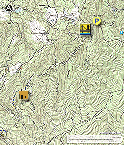
Mile 0.0 - From the parking area head up Morgans Mill Rd for 70 yards where the Appalachian Trail crosses the road. Go downhill/south on the Appalachian Trail as the trail winds downward crossing the largest stream on this hike Ashby Hollow, over a wooden footbridge, and past a campsite.
-
Mile 0.5 - Immediately after crossing the footbridge stay right and then cross a gravel road where the Appalachian Trail begins to climb Piney Ridge.
-
Mile 1.4 - From the top of the Piney Ridge the trail passes through a saddle and descends steeply to the stream in Bolden Hollow.
-
Mile 2.1 - Cross the stream in Bolden Hollow where there is a large area of Skunk Cabbage. Once across the stream there is a small campsite next to the trail. The Appalachian Trail will turn left following an old fire road for 100 yards before turning right climbing to the next ridge. At the ridgeline there are obstructed views to the west of the Winchester valley. From late Spring through Fall most of these vistas are obscured by foliage. Continue on the Appalachian Trail for another 0.3 miles to a point where the Appalachian Trail passes through a rocky area with another obstructed view to the west. Continue downhill and enter the Rod Hollow area and end of the 'Roller Coaster' section of the Appalachian Trail.
-
Mile 3.4 - Pass the northern terminus of the Fisher Hill Loop. This section of the Appalachian Trail in Rod Hollow can be very wet and boggy so wooden planking has been placed over the trail. Cross a small feeder stream, then arrive at the connector trail for the Rod Hollow Shelter.
-
Mile 3.9 - Turn right onto the Rod Hollow connecter trail and shortly cross the Rod Hollow stream. Immediately after crossing the stream there is a large campsite on the left. Continue up the trail for a short distance to the Rod Hollow Shelter.
-
Mile 3.95 - Arrive at the Rod Hollow Shelter. There is also a covered picnic table, multiple tent pad sites, and a privy. If you take this hike in April the Rod Hollow area blooms abundantly with Blue Bells. The shelter is the turn around point for the hike, so retrace your route on the Appalachian Trail back to the north.
-
Mile 7.5 - Arrive back at Morgans Mill Rd/VA605 and parking area.