Loading...

🎉 Enjoy a Free 7-Day Supporter Trial and Unlock Exclusive Perks — No Credit Card Required. Learn more.

Ashby Gap Hike

Directions
Map
Pictures
Send to App
Distance:
8.0 Miles / 12.9 km
Type:
Out-and-Back
Difficulty:
Moderate
Time to Hike:
4 hours
Features:
Appalachian Trail hike
Surface Type:
Dirt
Town:
Paris, Virginia
Directions:
39.016875, -77.962137
Added:
April 03, 2025
Updated:
April 06, 2025
Copy Trail Link Hiking this trail? Send a friend or family member a link to this trail guide for your own safety. Hike at your own risk (disclaimer)
Loading...
Loading...
490'

Total Change
1,721'

Ascent
1,730'

Descent

Download the Trail Route for Offline Use

Supporters get exclusive access to download trail routes to the MyHikes app for offline use. Stay prepared on your adventure, even without an internet connection! Become a Supporter today to unlock this feature and hike with confidence.

Send to App

Ashby Gap Hike

Another nice spring or fall hike closer to the DC Metro area. This is a out and back hike with two side loops, the main features being the small mountain streams, wildflowers, Myron Glaser Cabin, and the Rod Hollow Shelter. The best time to do this hike is springtime when the wildflowers are out and the streams are at their fullest.

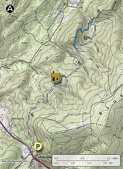
From the parking area on VA601 follow the blue blazed trail down from the end of the parking area for 0.1 miles to the intersection of the Appalachian Trail (AT). Turn right uphill/north on the AT as it passes over the first of four ridges, cross a small stream, pass over the second ridge, then arrive at the blue blazed trail that makes a side loop to the Myron Glaser cabin.

Turn left downhill on the blue blazed trail where it shortly joins a small road and turns right. Cross another stream and walk up to the Myron Glaser cabin. The cabin is maintained by the Potomac Appalachian Trail Club and is available for rental to PATC members only. The blue blazed trail passes around the back of the cabin and climbs back to the AT in another 0.2 miles.

Turn left on the AT crossing the next ridge and descending through Duke Hollow. After crossing the stream in Duke Hollow it will be another 0.4 miles to the Fisher Hill Loop Scenic Trail. The trail passes over Fisher Hill without any vistas, and is more of a scenic walk in the woods. Turn left on the blue blazed Fisher Hill Loop Scenic Trail as it passes over the top Fisher Hill then descends and rejoins the AT in 1.0 miles.

Turn right/south on the AT for 0.4 miles to the junction of the Rod Hollow Shelter. The shelter is 0.2 miles from the AT and usually has a good water source next to the stream in Rod Hollow. Continue south on the AT passing the the Fisher Hill Loop Scenic Trail in 0.4 miles you ascended earlier.

From this point you can follow the AT the 2.9 miles back to the parking area blue connector trail, or retrace your hike back past the Myron Glaser cabin.

Explore 55 trails near Paris, VA
  1. Parking

    39.016875, -77.962137
  2. Main Trailhead

    39.01702, -77.962031
No community routes found. To add your own hike as a Community Route for this Trail guide, leave a Trip Report with an attached GPX file.

Hazards

Ticks - Lyme Disease More Info (CDC)
Snakes
Poison Ivy/Oak

Seasons

All

Blaze Color

White

Trip Reports

Trail Guide By:
HikingUpward user profile picture
8.0 miles / 12.9 km

Weather Forecast

In Paris, VA

Explore Hiking Trails

You May Also Like

New York's Best Waterfalls - Whether you're planning a day hike, roadside stop, or a leisurely short walk, this guide provides hikers, travelers, and locals alike with 63 different locations to over 100 scenic waterfalls to help plan your next adventure!
Explore

New York's Best Waterfalls

Whether you're planning a day hike, roadside stop, or a leisurely short walk, this guide provides hikers, travelers, and locals alike with 63 different locations to over 100 scenic waterfalls to help plan your next adventure!

Read
25 Best Day Hikes in North Carolina - Discover the top 25 best day hikes in North Carolina, from breathtaking waterfalls to mountain peaks. Explore hidden gems, scenic views, and trails suitable for all skill levels, perfect for your next outdoor adventure.
Explore

25 Best Day Hikes in North Carolina

Discover the top 25 best day hikes in North Carolina, from breathtaking waterfalls to mountain peaks. Explore hidden gems, scenic views, and trails suitable for all skill levels, perfect for your next outdoor adventure.

Read

Before you boogie...

Find our trail guides useful? Consider becoming a Supporter to unlock perks!

MyHikes is an indie platform that makes exploring public trails easier for everyone. The platform has no investors, no ads, and is owned and operated by one person, Dave Miller. Dave has personally mapped and written over 1,800 trail guides on MyHikes for the public to explore. MyHikes has helped millions outdoor enthusiasts plan their next adventure.

But it takes a lot of time 🕦, money 💰, work, and espresso shots ☕ to run MyHikes, including hiking , mapping , writing , and publishing new trails with high-quality (accurate) information... along with software engineering (coding) the platform like building new features, website and mobile app development (iOS and Android), site maintainance . and much much more.

Supporters unlock website and mobile app perks with an annual one-time payment of $25 (you renew) 😎👍. Or you can simply make a Donation of your choice. Otherwise, you can support us by telling your friends about MyHikes - both quick and free 🎉

Admin user profile picture

Dave Miller
MyHikes Founder