The Arch Tree Loop at Sinnemahoning State Park near Wharton, Pennsylvania is an easy 0.4-mile walk that leads to an arch tree, and follows the paths on the grounds of the Sinnemahoning Wildlife Center.
Trails
This walk includes the path to the Arch Tree. A loop is made by way of another path that leads onto the Lowlands Trail for a short section. From the Lowlands Trail, the walk returns using paths in the meadow at the Arch Tree Viewing Area. The Park Paved Road connects the Arch Tree Trailhead, the Lowlands Trailhead and the parking area at the Wildlife Center.
This Arch Tree Loop encompasses the Discovery Area, an outdoor place for study groups to explore, also at the at the Sinnemahoning Wildlife Center.
Hike Description
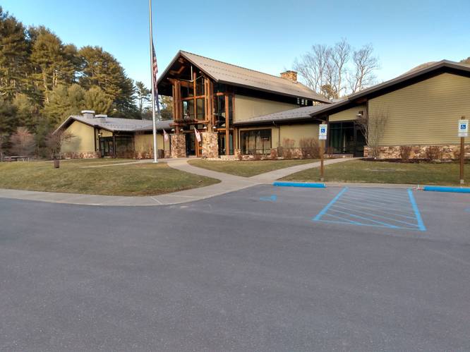
Hikers start at the Wildlife Center at the parking coordinates provided before walking a short distance south along the Park Paved Road for about 300 feet to reach the Lowlands Trailhead post.
Lowlands Trail Trailhead Path - Mile 0.0
At the "LLT" Post, take a left-hand turn on the Lowlands Trail access path. Continue across the lawn for about 200 feet to the next "LTT" post with orange diamond and turn right. The trail will head downhill slightly through the woods to a bridge that crosses Upper Logue Run.
Along the lawn section, the hiker goes past the two entrances to the Discovery Area.
Lowlands Trail Section - Mile 0.1
Immediately beyond the bridge, the hiker turns right onto the Lowlands Trail and continues on the Lowlands Trail for about 400 feet. Look for an unmarked grassy path, that leads off the Lowlands Trail to the right and heads up-the-hill into the open field above the Lowlands Trail.
Arch Tree Viewing Area - Mile 0.3
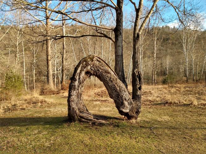
At mile 0.3, hikers will reach a bench that faces the Arch Tree. Here, hikers can take a break before heading onward. The tree trunk arches to about 7 feet high and then bends back down to the ground to form an arch, then crowns upward on two main branches to fill out a 40 feet canopy.
A path leads directly from the Arch Tree to the Park Paved Road. To completed this loop, follow this path to the Arch Tree trailhead on the Park Paved Road that leads back across Upper Logue Run and returns the hiker to the parking area at the Wildlife Center.
Points of Interest - Possible Old Water Tower Footing hidden below the Arch Tree
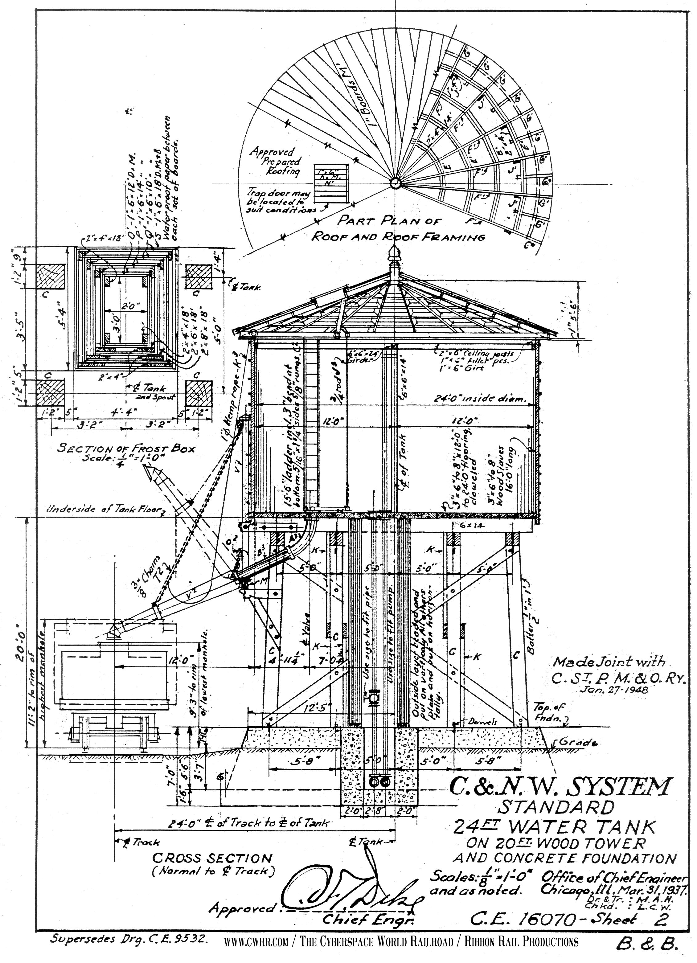
About 100 feet below the Arch Tree, just off the path on the edge of the meadow is an old concrete structure hidden in overgrowth of tall weeds. Since this old relic is located just above the old railroad grade, now the Lowlands Tail, and next to Upper Logue Run, it could possibly be the remains of a water tank structure once used by the railroad steam engines of the past. Just a hunch, but it appears to sit high enough on the embankment to be properly positioned above the top of railroad cars on the tracks below. Could this have been a water stop on a railroad, that serviced steam locomotives stopped to replenish the water cars? Could well-be. The old footing, which would have been the bottom of the water tank structure, sits about 30 feet above the elevation of the railroad grade. Rail cars are 13 to 15 feet in height, and the height needed for water spout clearance seems correct. As does the centerline distance between the railroad line and water tank, again at about 30 feet. Any experts in the subject are more than welcome to provide an opinion on this speculation.
There is also a much younger Apple Orchard in the meadow below the Arch Tree.
What thoughts can one ponder on the bench by the Arch Tree. Is the Arch Tree the mother tree for this young Apple Orchard? No, since the arch tree is a maple. But perhaps, a deity from the ancient forest magically created the apple orchard from the maple arch tree. No, not likely. Maybe Native Americans bent the young maple tree to create a permanent marker to show the way to other important landmarks. Possibility. Maybe nature did the bending with snow and ice. That's more likely the explanation.
Conclusion: Pondered me enough here, time to go onward to the next adventure.
Discovery Area
Finally, inside of this Loop contains a Discovery Area. The Discovery Area has two entrances facing toward the Sinnemahoning Park Wildlife Center. Trails in this wooded area are designed in a loop that have stone steps and rustic benches for group studies of the forest plants, ecosystems and entomology - and all things creepy and crawly.
The Discovery Area banks along Upper Logue Run for some creek access.
Parking
Hikers will find parking at the coordinates provided at the Park Office and Wildlife Center at Sinnemahoning State Park.
Pets
Dogs are allowed if leashed and their waste must be carried out by the hiker.
Camping
Camping is not allowed on this trail, unless the camper has a reservation at the pre-paid campsites located at the park campground located about 1 mile south of this trail.
Restrooms
There are flush bathrooms available during office hours inside the Sinnemahoning Wildlife Center located in the middle of the park.
About the Lowlands Trail
The Lowlands Trail is a 4.8-mile scenic hike in it's entirety and follows the First Fork Sinnemahoning Creek through the upper end of the Sinnemahoning State Park. The trail was built on the former Buffalo & Susquehanna railroad bed, that operated in the early 1900's. The railroad was then purchased in 1932 by the Baltimore and Ohio Railroad. This rail-line was closed after being badly damaged in the devastating flood of 1942.
Today, the Lowlands Trail is a multi-use trail (hiking, biking, cross-country skiing and snowmobile).
Trails
This walk includes the path to the Arch Tree. A loop is made by way of another path that leads onto the Lowlands Trail for a short section. From the Lowlands Trail, the walk returns using paths in the meadow at the Arch Tree Viewing Area. The Park Paved Road connects the Arch Tree Trailhead, the Lowlands Trailhead and the parking area at the Wildlife Center.
This Arch Tree Loop encompasses the Discovery Area, an outdoor place for study groups to explore, also at the at the Sinnemahoning Wildlife Center.
Hike Description
Hikers start at the Wildlife Center at the parking coordinates provided before walking a short distance south along the Park Paved Road for about 300 feet to reach the Lowlands Trailhead post.
Lowlands Trail Trailhead Path - Mile 0.0
At the "LLT" Post, take a left-hand turn on the Lowlands Trail access path. Continue across the lawn for about 200 feet to the next "LTT" post with orange diamond and turn right. The trail will head downhill slightly through the woods to a bridge that crosses Upper Logue Run.
Along the lawn section, the hiker goes past the two entrances to the Discovery Area.
Lowlands Trail Section - Mile 0.1
Immediately beyond the bridge, the hiker turns right onto the Lowlands Trail and continues on the Lowlands Trail for about 400 feet. Look for an unmarked grassy path, that leads off the Lowlands Trail to the right and heads up-the-hill into the open field above the Lowlands Trail.
Arch Tree Viewing Area - Mile 0.3
At mile 0.3, hikers will reach a bench that faces the Arch Tree. Here, hikers can take a break before heading onward. The tree trunk arches to about 7 feet high and then bends back down to the ground to form an arch, then crowns upward on two main branches to fill out a 40 feet canopy.
A path leads directly from the Arch Tree to the Park Paved Road. To completed this loop, follow this path to the Arch Tree trailhead on the Park Paved Road that leads back across Upper Logue Run and returns the hiker to the parking area at the Wildlife Center.
Points of Interest - Possible Old Water Tower Footing hidden below the Arch Tree
About 100 feet below the Arch Tree, just off the path on the edge of the meadow is an old concrete structure hidden in overgrowth of tall weeds. Since this old relic is located just above the old railroad grade, now the Lowlands Tail, and next to Upper Logue Run, it could possibly be the remains of a water tank structure once used by the railroad steam engines of the past. Just a hunch, but it appears to sit high enough on the embankment to be properly positioned above the top of railroad cars on the tracks below. Could this have been a water stop on a railroad, that serviced steam locomotives stopped to replenish the water cars? Could well-be. The old footing, which would have been the bottom of the water tank structure, sits about 30 feet above the elevation of the railroad grade. Rail cars are 13 to 15 feet in height, and the height needed for water spout clearance seems correct. As does the centerline distance between the railroad line and water tank, again at about 30 feet. Any experts in the subject are more than welcome to provide an opinion on this speculation.
There is also a much younger Apple Orchard in the meadow below the Arch Tree.
What thoughts can one ponder on the bench by the Arch Tree. Is the Arch Tree the mother tree for this young Apple Orchard? No, since the arch tree is a maple. But perhaps, a deity from the ancient forest magically created the apple orchard from the maple arch tree. No, not likely. Maybe Native Americans bent the young maple tree to create a permanent marker to show the way to other important landmarks. Possibility. Maybe nature did the bending with snow and ice. That's more likely the explanation.
Conclusion: Pondered me enough here, time to go onward to the next adventure.
Discovery Area
Finally, inside of this Loop contains a Discovery Area. The Discovery Area has two entrances facing toward the Sinnemahoning Park Wildlife Center. Trails in this wooded area are designed in a loop that have stone steps and rustic benches for group studies of the forest plants, ecosystems and entomology - and all things creepy and crawly.
The Discovery Area banks along Upper Logue Run for some creek access.
Parking
Hikers will find parking at the coordinates provided at the Park Office and Wildlife Center at Sinnemahoning State Park.
Pets
Dogs are allowed if leashed and their waste must be carried out by the hiker.
Camping
Camping is not allowed on this trail, unless the camper has a reservation at the pre-paid campsites located at the park campground located about 1 mile south of this trail.
Restrooms
There are flush bathrooms available during office hours inside the Sinnemahoning Wildlife Center located in the middle of the park.
About the Lowlands Trail
The Lowlands Trail is a 4.8-mile scenic hike in it's entirety and follows the First Fork Sinnemahoning Creek through the upper end of the Sinnemahoning State Park. The trail was built on the former Buffalo & Susquehanna railroad bed, that operated in the early 1900's. The railroad was then purchased in 1932 by the Baltimore and Ohio Railroad. This rail-line was closed after being badly damaged in the devastating flood of 1942.
Today, the Lowlands Trail is a multi-use trail (hiking, biking, cross-country skiing and snowmobile).


