Loading...

🔥 End of Summer sale! 50% off on Supporter Accounts — now through September 1st. Learn More.

Apple Orchard Falls Hike

Directions
Map
Pictures
Send to App
Distance:
5.8 Miles / 9.3 km
Type:
Loop
Difficulty:
Moderate
Time to Hike:
2 hours, ~54 minutes
Features:
Surface Type:
Dirt
Park:
Jefferson National Forest
Town:
Munford, Virginia
Directions:
37.529633, -79.552983
Added:
February 28, 2025
Updated:
April 05, 2025
Guide by:
Copy Trail Link Hiking this trail? Send a friend or family member a link to this trail guide for your own safety. Hike at your own risk (disclaimer)
Loading...
Loading...
1,411'

Total Change
1,684'

Ascent
1,679'

Descent

Download the Trail Route for Offline Use

Supporters get exclusive access to download trail routes to the MyHikes app for offline use. Stay prepared on your adventure, even without an internet connection! Become a Supporter today to unlock this feature and hike with confidence.

Send to App

Apple Orchard Falls Hike

Are you looking for a hike with lots of streams? If so, this is a hike you should do, and is one of the most popular hikes in the Jefferson N.F. You will either be right next to streams or within sight of a stream for about 90% of this hike. The highlight of the trail is the 200’ Apple Orchard Falls with a very nice viewing area constructed by the Forest Service in 2000. Shane “The Mountain Lab” joined us on this hike and true to Lab nature, he was wet most of the trip!!

There are some great camping spots within the first mile of the trail and a really good one near the end of the Cornelius Creek Trail just prior to the parking area. For such a short hike it has some of the best stream views of any hikes we have done in Virginia.

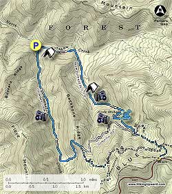
From the parking area take the bridge to the left of the kiosk to begin the hike on the blue blazed Apple Orchard Falls (AOF) Trail. In 0.2 miles you will come to an intersection, bear right and stay on the AOF Trail. About 1.0 mile later you will arrive at two bridges and another campsite, take the 2nd one over the creek continuing up on the AOF trail. The next 0.75 miles starts climbing more steeply until you reach Apple Orchard Falls. You will want to stop here and have lunch and get some good photos of the Falls.

Beyond the Falls you will start to climb a series of wooden stairs coming very quickly to the only overlook with a wooden bench of the whole circuit, and just beyond that another small waterfall. Go another 0.3 miles to the intersection of the Apple Orchard Falls Road (a seeded fire road) and take a right. Follow it 1.0 mile to the blue blazed Cornelius Creek Trail. The Fire Road bears to the right but stay straight to go on the Cornelius Creek Trail.

Follow the Cornelius Creek Trail for 2.2 miles to the parking area. The trail follows Cornelius Creek and will include two crossings. The creek was flowing well on our trip and made for difficult crossings and some wet feet. There are also some very good swimming holes on the way down. There are multiple places you will want to stop and take photos of the creek flowing over the rocks.

Warning: Be careful of the plentiful stinging nettles near the creeks and ticks on the fire road.

Note: An alternative parking area if all you only want to see the Falls is at Sunset Field, near Milepost 78.4 on the Blue Ridge Parkway. It is approximately 1.5 miles down to the Falls from Sunset Field.

Explore 26 trails near Munford, VA
  1. Parking

    37.529633, -79.552983
  2. Main Trailhead

    37.529597, -79.552946
No community routes found. To add your own hike as a Community Route for this Trail guide, leave a Trip Report with an attached GPX file.

Hazards

Ticks - Lyme Disease More Info (CDC)
Snakes
Poison Ivy/Oak

Seasons

All

Blaze Color

Blue

Trip Reports (Reviews)

Rated 3.75 out of 5 based on 40 ratings.
By: Stephanie
5.8 miles / 9.3 km
October 28, 2017
My husband, myself and our 2 dogs hiked this trail. We had a great time although the elevation was pretty tough at some points. We did see some snakes along the trail. The falls were beautiful and if you go further up there's a beautiful view of the mountains. We were on the trail mostly by ourselves until we got closer to the falls.
Legacy Review
By: Jeff
5.8 miles / 9.3 km
August 24, 2016
This hike punches above its weight in difficulty, but is worth the work! We set out from the upper trailhead (Sunset Field, on the BRP) around 8:30 intending to hike this loop clockwise, with a small detour. From the intersection of the AT and Cornelius Creek Trail, we continued Southbound on the AT for just over a half mile, up a modest hill, to the Black Rock Overlook. I think it offers a better view of the valley than anything you'll see on the loop itself, and is absolutely worth the sidetrip. Continuing back along the trail, we found the descent along Cornelius Creek Trail to be a leg-burner (this would be a theme for the day) as it was pretty steep, prolonged, and had plenty of cobble-sized stones to mess up your footing. Hiking along Cornelius Creek was lovely, with an abundance of swimming holes, shelfs, cascades, etc. There were a few large-ish trees down across the trail here, but nothing we or the dog couldn't navigate. Heading up Apple Orchard Falls Trail was less remarkable both in views and character until we got closer to the falls. The trail steepens considerably below the falls, so we took a long break for water and snacks at the platform there. Following this, it was 1.5 miles back uphill to the trailhead. We'd hiked down the falls and back before without any complaint, but doing the same trail after 7 miles is a much harder story. A very worthwhile hike, but not as easy as you may think looking at the mileage and elevation if you're hiking from the top.
Legacy Review
By: Shawn R.
5.8 miles / 9.3 km
January 09, 2016
This is a wonderful hike which is alongside of a creek a majority of the way. We went on a day which was very foggy and cool which meant two things: no other people and no view(s). Although we weren't able to see anything where the overlook was, this was still a phenomenal hike. There were a couple of areas which could be used as swimming holes during much warmer weather. Also, there were two areas with creek crossings that almost guaranteed some wet feet. It's important to note that it is fairly easy to get "lost." We had to retrace our steps a couple of times. The blazes were spread out far too much and at one point misleading. There was a blue blaze on a tree on what looked like where the trail could go, but it turned out the trail kept going a different direction which had no blazes. This trail then led to fire road. From there it was fairly straightforward. Just keep walking on that road until you reach a sign which will lead you in the right direction. Despite needing to backtrack a few times the hike only took a little more than 4 hours with several small breaks to enjoy the falls.
Legacy Review

Weather Forecast

In Munford, VA

Explore Hiking Trails

You May Also Like

New York's Best Waterfalls - Whether you're planning a day hike, roadside stop, or a leisurely short walk, this guide provides hikers, travelers, and locals alike with 63 different locations to over 100 scenic waterfalls to help plan your next adventure!
Explore

New York's Best Waterfalls

Whether you're planning a day hike, roadside stop, or a leisurely short walk, this guide provides hikers, travelers, and locals alike with 63 different locations to over 100 scenic waterfalls to help plan your next adventure!

Read
25 Best Day Hikes in North Carolina - Discover the top 25 best day hikes in North Carolina, from breathtaking waterfalls to mountain peaks. Explore hidden gems, scenic views, and trails suitable for all skill levels, perfect for your next outdoor adventure.
Explore

25 Best Day Hikes in North Carolina

Discover the top 25 best day hikes in North Carolina, from breathtaking waterfalls to mountain peaks. Explore hidden gems, scenic views, and trails suitable for all skill levels, perfect for your next outdoor adventure.

Read

Before you boogie...

Find our trail guides useful? Consider becoming a Supporter to unlock perks!

MyHikes is an indie platform that makes exploring public trails easier for everyone. The platform has no investors, no ads, and is owned and operated by one person, Dave Miller. Dave has personally mapped and written over 1,800 trail guides on MyHikes for the public to explore. MyHikes has helped millions outdoor enthusiasts plan their next adventure.

But it takes a lot of time 🕦, money 💰, work, and espresso shots ☕ to run MyHikes, including hiking , mapping , writing , and publishing new trails with high-quality (accurate) information... along with software engineering (coding) the platform like building new features, website and mobile app development (iOS and Android), site maintainance . and much much more.

Supporters unlock website and mobile app perks with an annual one-time payment of $25 (you renew) 😎👍. Or you can simply make a Donation of your choice. Otherwise, you can support us by telling your friends about MyHikes - both quick and free 🎉

Admin user profile picture

Dave Miller
MyHikes Founder