Loading...

🎉 Enjoy a Free 7-Day Supporter Trial and Unlock Exclusive Perks — No Credit Card Required. Learn more.

Antietam Burnside Bridge Hike

Directions
Map
Pictures
Send to App
Distance:
4.4 Miles / 7.1 km
Type:
Loop
Difficulty:
Easy
Time to Hike:
2 hours, ~12 minutes
Features:
Surface Type:
Dirt
Town:
Sharpsburg, Maryland
Directions:
39.462127, -77.736068
Added:
March 20, 2025
Updated:
April 06, 2025
Copy Trail Link Hiking this trail? Send a friend or family member a link to this trail guide for your own safety. Hike at your own risk (disclaimer)
Loading...
Loading...
144'

Total Change
394'

Ascent
399'

Descent

Download the Trail Route for Offline Use

Supporters get exclusive access to download trail routes to the MyHikes app for offline use. Stay prepared on your adventure, even without an internet connection! Become a Supporter today to unlock this feature and hike with confidence.

Send to App

Antietam Burnside Bridge Hike

On September 17, 1862, at what is now the Antietam National Battlefield near Sharpsburg MD, Union and Confederate armies fought each other resulting in over 23,000 casualties. There were three primary engagements that day that would become know as The Cornfield, Bloody Lane, and The Burnside or Lower Bridge.

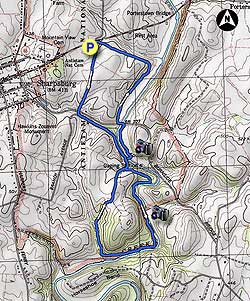
This hike is a figure 8 loop that crosses the Burnside Bridge and follows the hauntingly beautiful Antietam Creek where so many soldiers lost their lives or were injured during one of the bloodiest battles of the Civil War.

  • Mile 0.0 – Park at the small pullout on Rodman Ave and intersection of US34/Boonsboro Pike. The first mile of the circuit follows paved roads in the park, however traffic is generally light and is required to maintain low speeds. Start south along Rodman Ave, which during 1862 was know as Sherrick's Lane. Cross over the high point of the road, then descend past the Sherrick Farm on the left before Rodman Ave ends at the intersection of Branch Ave.
  • Mile 0.6 - Turn left on Branch Ave shortly passing the Otto Farm and continue for 0.4 miles at which point stay left on the pedestrian path towards the Burnside Bridge.
  • Mile 1.1 - Don't cross the Burnside Bridge, but stay right uphill on the path to the parking area. Before the path reaches the parking area turn left onto the Snavely Ford Trail following it down to Antietam Creek and first of several benches.
  • Mile 1.3 - Continue following the Sanely Ford Trail downstream for 0.6 miles where the trail turns sharply right uphill at the junction of a small side trail on the left. Stay on the wider Snavely Ford Trail uphill to the right, soon pass the Final Attack Trail on the left, and reach the high point where the trail leaves the forest. Descend the remaining 0.2 miles back to the Burnside Bridge parking area and head down to the bridge.
  • Mile 3.2 - Cross the Burnside Bridge and take the Union Advance Trail to the left where it joins the Sherrick Farm Trail and goes up to the Burnside Bridge Rd. in 0.2 miles.
  • Mile 3.4 - Cross the bridge where the Sherrick Farm Trail passes a gate and re-enters the forest on the opposite site of the road. Follow the Sherrick Farm Trail for 0.5 miles to the intersection of the Three Farms Trail.
  • Mile 3.9 - Turn left uphill on the Sherrick Farm trail passing two fields for the remaining 0.5 miles
  • Mile 4.4 - Arrive back at the parking area at the corner of Rodman Ave and US34.
Explore 29 trails near Sharpsburg, MD
  1. Parking

    39.462127, -77.736068
  2. Main Trailhead

    39.462202, -77.735953
No community routes found. To add your own hike as a Community Route for this Trail guide, leave a Trip Report with an attached GPX file.

Seasons

All

Trip Reports

Trail Guide By:
HikingUpward user profile picture
4.4 miles / 7.1 km

Weather Forecast

In Sharpsburg, MD

Explore Hiking Trails

You May Also Like

Colorado's Million Dollar Highway - Plan a day's drive adventure along the iconic Million Dollar Highway in Colorado. Explore the best short trails, roadside stops, waterfalls, vistas, ghost towns, and hot springs within a ~6 hour road trip.
Explore

Colorado's Million Dollar Highway

Plan a day's drive adventure along the iconic Million Dollar Highway in Colorado. Explore the best short trails, roadside stops, waterfalls, vistas, ghost towns, and hot springs within a ~6 hour road trip.

Read
New York's Best Waterfalls - Whether you're planning a day hike, roadside stop, or a leisurely short walk, this guide provides hikers, travelers, and locals alike with 63 different locations to over 100 scenic waterfalls to help plan your next adventure!
Explore

New York's Best Waterfalls

Whether you're planning a day hike, roadside stop, or a leisurely short walk, this guide provides hikers, travelers, and locals alike with 63 different locations to over 100 scenic waterfalls to help plan your next adventure!

Read

Before you boogie...

Find our trail guides useful? Consider becoming a Supporter to unlock perks!

MyHikes is an indie platform that makes exploring public trails easier for everyone. The platform has no investors, no ads, and is owned and operated by one person, Dave Miller. Dave has personally mapped and written over 1,800 trail guides on MyHikes for the public to explore. MyHikes has helped millions outdoor enthusiasts plan their next adventure.

But it takes a lot of time 🕦, money 💰, work, and espresso shots ☕ to run MyHikes, including hiking , mapping , writing , and publishing new trails with high-quality (accurate) information... along with software engineering (coding) the platform like building new features, website and mobile app development (iOS and Android), site maintainance . and much much more.

Supporters unlock website and mobile app perks with an annual one-time payment of $25 (you renew) 😎👍. Or you can simply make a Donation of your choice. Otherwise, you can support us by telling your friends about MyHikes - both quick and free 🎉

Admin user profile picture

Dave Miller
MyHikes Founder