Loading...

WINTER SALE! 50% OFF Supporter Accounts — now through January 31st. Learn More.

Antietam Bloody Lane Hike

On September 17, 1862, at what is now the Antietam National Battlefield near Sharpsburg MD, Union and Confederate armies fought each resulting in over 23,000 casualties. There were three primary engagements that day that would become know as The Cornfield, Bloody Lane, and The Burnside or Lower Bridge.

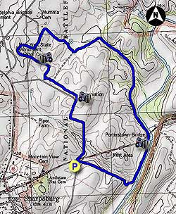
The Bloody Lane loop hike is the sister hike to the Burnside Bridge hike, and starts at the same parking area on Rodman Ave. This loop is the northern loop where you walk along Bloody Lane, pass the visitor center, and return along Antietam Creek.

  • Mile 0.0 – Park at the small pullout on Rodman Ave and intersection of US34/Boonsboro Pike. Cross over US34/Boonsboro Pike and follow paved Rodman Ave for the first 0.7 miles to the Observation Tower.
  • Mile 0.6 - From the top of the Observation Tower you have a panoramic view of the entire northern Antietam Battlefield, with the view to the northwest looking directly up Bloody Lane and the Antietam Battlefield visitor center in the distance.
  • Mile 0.9 - Walk down Bloody Lane for 0.3 miles. Where the Bloody Lane Trail meets back with the road it will turn right in to the field for 0.1 miles before turning left towards the Visitor Center. Shortly crossing a road and climb the small hill to the Visitor Center.
  • Mile 1.4 - Head back down the field you just climbed to the Visitor Center and now turn left on the small paved road you just crossed. Follow the road down to Mumma Farm.
  • Mile 1.6 - Turn right at the information kiosk and Three Farms Trail as it descends a passes around the Roulette Farm. Continue down the trail for another 0.2 miles and reach the intersection of the Bloody Lane Trail.
  • Mile 1.9 - Turn left remaining on the Three Farms Trail as it passes two fields then bears right going through a wooded area and crossing a ridge. The trail will reach Antietam Creek and pass underneath US34 in 1.6 miles from the Bloody Lane intersection.
  • Mile 2.7 - Continue to follow The Three Farms Trail for another 0.5 miles to the intersection of the Sherrick Farm Trail.
  • Mile 3.4 - Turn right uphill on the Sherrick Farm Trail and pass two fields for the remaining 0.5 miles back to the parking area.
  • Mile 4.0 - Arrive back at the parking area on US34/Boonsboro Pike.
Explore 29 trails near Sharpsburg, MD

Know Before You Go

  • The 4-mile Bloody Lane loop hike at Antietam National Battlefield explores the site of a major Civil War battle, offering views of key locations like Bloody Lane and the Antietam Battlefield visitor center.
  • The hike starts on Rodman Ave, includes an observation tower with panoramic battlefield views, and follows a path through fields, woods, and along Antietam Creek.
  • The route combines sections of paved road, field trails, and wooded paths, passing historical landmarks like Mumma and Roulette Farms before returning to the starting point.
Interactive topographic map for Antietam Bloody Lane Hike located in Sharpsburg, MD. Click the "View Map" button to load GPS coordinates and trail markers.
Get directions
Distance
4.0 mi
Difficulty
Easy
Type
Loop
Est. Time
2 hrs
Elev. Gain
281'
Rating
3.5
Added
March 20, 2025
Updated
April 06, 2025

Weather Forecast

Loading...
Total Change
199'
Ascent
281'
Descent
281'
Loading...

Download the GPX Data for Offline Use

Supporters get exclusive access to download trail routes to the MyHikes app for offline use. Stay prepared on your adventure, even without an internet connection! Become a Supporter today to unlock this feature and hike with confidence.

Download Antietam Bloody Lane Hike GPX Data to the MyHikes Mobile App

Features

Vista / Lookout Point
Dogs
Water Source

Points of interest

  1. Parking

    39.462127, -77.736068
  2. Main Trailhead

    39.462127, -77.736068

Safety information

For your own safety: plan ahead, let someone know where you'll be, and hike at your own risk.

Availability

All seasons

Surface type

Dirt

Trip Reports (Reviews)

Rated 3.5 out of 5 based on 2 ratings.

Ready to help fellow hikers? Add a trip report to share your experience and provide valuable insights for other hikers!

By: Sean
4.0 miles / 6.4 km
October 13, 2016
A nice hike, informative too depending on how much time you devote to numerous historical signage and monuments along the path. Most of it is in open area, maybe one-fourth or so in "woods." It's a fee area, $5 for individuals and $10 for cars as of this writing. The fee can be paid in the visitor center at the counter where you enter. In exchange you'll get a nice map with additional historical information. The gift shop has guides on individual trails, for a dollar each, that provide considerable detail. There's a 27-minute reenactment movie in the visitor center that runs every hour and half hour.
Legacy Review
By: SarahandMatt
4.0 miles / 6.4 km
February 22, 2014
We choose this hike because it was close to home (an hour's drive) and close to some good food (Shepardstown). The day started out chilly and wuickly warmed up with lots of sunshine. There is not a ton of shade on the first stretch of this hike. We hiked up to the tower which was neat. We then proceded to walk down the sunken road (Which we were not sure if we were allowed to walk there or stay to the road, so we walked in the grass) We came to a sign that said Bloody Lane Trail, and was a right hand turn into the cornfield, I thought this was the correct way. I was wrong, which was not a huge deal, just did not get a chance to complete the bloody lane portion. We made our way up to the visitor center, where you had to pay for the museum (which we did not go to). Then retraced our wrong directions back to the woods. The foot of snow, and inch of ice made it a little hard to travel, but was fun and different. Overall a good chilly day hike, when you don't want to tackle too many miles, or want a short stroll through the woods and battlefield.
Legacy Review
No community routes found. To add your own hike as a Community Route for this Trail guide, leave a Trip Report with an attached GPX file.

Popular categories

Scenic mountain view representing vista trails
Vista trails
Scenic gorge of cascades representing waterfall trails
Waterfall hikes
Rugged mountain terrain representing summit trails
Summit trails
Scenic mountain view representing dog-friendly trails
Dog-friendly
Scenic campsite with a view representing camping trails
Camping trails
Appalachian Trail logo representing A.T. hikes
A.T. hikes

You May Also Like

Colorado's Million Dollar Highway - Plan a day's drive adventure along the iconic Million Dollar Highway in Colorado. Explore the best short trails, roadside stops, waterfalls, vistas, ghost towns, and hot springs within a ~6 hour road trip.
Explore

Colorado's Million Dollar Highway

Plan a day's drive adventure along the iconic Million Dollar Highway in Colorado. Explore the best short trails, roadside stops, waterfalls, vistas, ghost towns, and hot springs within a ~6 hour road trip.

Read
🍪 We use cookies to learn about site usage and to serve map tiles. You may block cookies manually in the browser. By continuing you agree. Learn more