Alpine Vista via Loyalsock Trail at Loyalsock State Forest near Forksville, Pennsylvania is an easy 0.6-mile out-and-back hike that leads to a stunning view of the Loyalsock Creek Valley from Upper Alpine Vista.
After exploring Alpine Vista, the hike leads back to Coal Mine Road for a total of 0.6-miles out-and-back. This length does not include the walk from parking to the trailhead and back.
Parking
Hikers will find a large parking turnout near the coordinates provided, located south of the Loyalsock Trail along Coal Mine Road. The turnout is large enough to fit a dozen vehicles as of December 2024. There is no winter maintenance along Coal Mine Road, so you must drive at your own risk if there's snow/ice built-up.
Timber Rattlesnakes: This area is home to the Timber Rattlesnake which can be found roaming the forest floor between the end of April and early October each year. Be on the lookout and give any rattlers you find plenty of space.
Trails
This hike follows one named trail and one forest road: Coal Mine Road, Loyalsock Trail (yellow blazes).Hiking to Alpine Vista
This very short hike begins along Coal Mine Road where hikers will find the Loyalsock Trail bisects. The hike follows the Loyalsock Trail as it undulates its way along the top of a broad plateau. The trail is littered with roots and during the winter, can be slick and slippery without proper traction. Eventually, the trail ascends gradually up to Alpine Vista, which is located just 0.3-miles from the trailhead.Alpine Vista - Mile 0.3
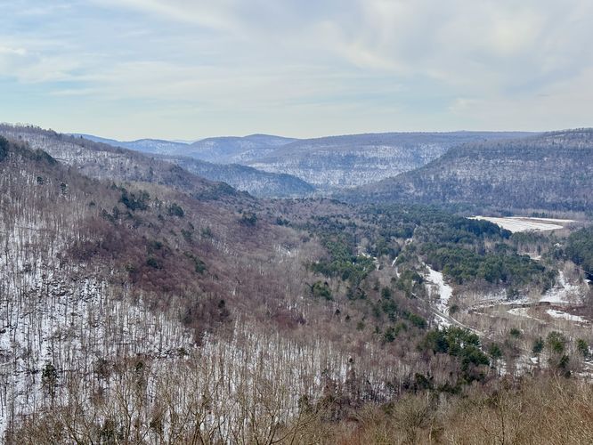
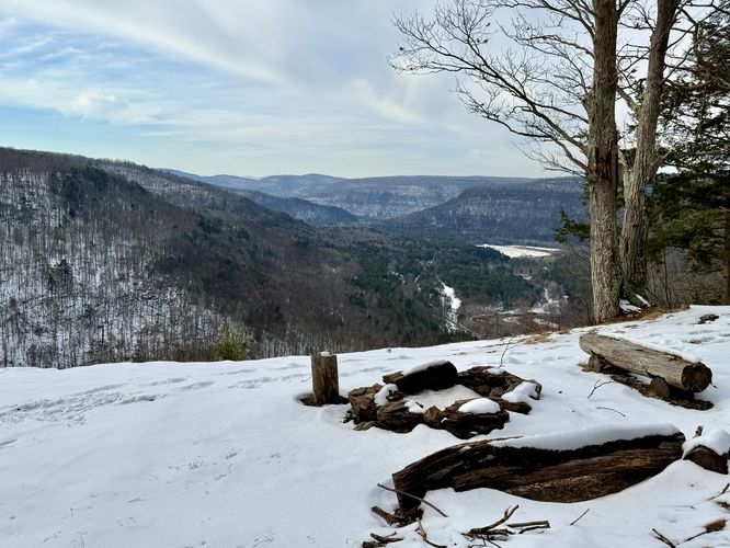
Hikers will reach Alpine Vista around mile 0.3 where you'll find sweeping views of Loyalsock Creek as it winds its way through the valley below. In the distance, on the left-hand side is High Knob which is known for the drive-up vista, High Knob Overlook. Straight ahead in the distance is Hogback Hill, Gooseberry Hill, and on a clear day you can even spot Sharp Top as it sits above the other peaks the horizon.Campsite at Alpine Vista - Mile 0.3
Hikers will also find a campsite at Alpine Vista, located along the forest's edge at the view. This spot is great for a backpacking trip as you get the best views right outside of your tent.After exploring Alpine Vista, the hike leads back to Coal Mine Road for a total of 0.6-miles out-and-back. This length does not include the walk from parking to the trailhead and back.
Camping & Backpacking
Backpacking and camping is permitting at Loyalsock State Forest per the state forest rules and regulations. As of December 2024, there's a designated campsite located directly at Alpine Vista. Please follow all state forest rules and regulations if backcountry / dispersed / primitive camping.Parking
Hikers will find a large parking turnout near the coordinates provided, located south of the Loyalsock Trail along Coal Mine Road. The turnout is large enough to fit a dozen vehicles as of December 2024. There is no winter maintenance along Coal Mine Road, so you must drive at your own risk if there's snow/ice built-up. Pets
Dogs are allowed if leashed and must be cleaned up after.Warning
Steep cliffs: This hike leads to steep terrain, including cliffs. Watch your step and hike at your own risk.Timber Rattlesnakes: This area is home to the Timber Rattlesnake which can be found roaming the forest floor between the end of April and early October each year. Be on the lookout and give any rattlers you find plenty of space.