Yatesville Falls at Yatesville Falls State Forest near Sprakers, New York is a moderate 0.5-mile out-and-back hike that leads to the 30-foot tall waterfall.
Drive-Up Waterfall
Note that the state forest map, as of August 2023, is no longer accurate and that the gate blocking traffic on the state forest entrance road is no longer there. Visitors can drive right up to the waterfall by driving down this trail if they wish. Otherwise, enjoy a peaceful forest hike to reach the falls.
Hike Description
This hike begins at the parking coordinates provided along the entrance road to Yatesville Falls State Forest. At the parking area is a trailhead kiosk which depicts the trail and waterfall, though the map is outdated as there's no longer a gate on the road.
The hike down along the forest road is peaceful, quiet, and during the Summer includes wildflowers and sometimes a red-spotted newt crossing the gravel.
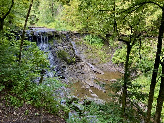
Yatesville Falls - Mile 0.25
Around mile 0.25, hikers will reach the viewing platform for Yatesville Falls which cascades down the creek's bedrock at 30-feet tall. During late Summer, the water is flowing, but could be stronger - so this waterfall is likely flowing more heavily during Spring months.
If you wish, you can follow the road out just a bit more - as shown in the GPS track - to reach the top of Yatesville Falls. Hikers can go to the top of the waterfall if they wish, but the view is best from the road.
Parking
Hikers can park right at the waterfall if they wish, but the parking coordinates for this short forest walk are located up the hill from the waterfall. The road that leads into Yatesville Falls is riddled with potholes, so watch where you're driving.
Pets
Dogs are allowed if leashed and should be cleaned up after.
Difficulty
This trail should be considered easy-to-moderate at worst.
Drive-Up Waterfall
Note that the state forest map, as of August 2023, is no longer accurate and that the gate blocking traffic on the state forest entrance road is no longer there. Visitors can drive right up to the waterfall by driving down this trail if they wish. Otherwise, enjoy a peaceful forest hike to reach the falls.
Hike Description
This hike begins at the parking coordinates provided along the entrance road to Yatesville Falls State Forest. At the parking area is a trailhead kiosk which depicts the trail and waterfall, though the map is outdated as there's no longer a gate on the road.
The hike down along the forest road is peaceful, quiet, and during the Summer includes wildflowers and sometimes a red-spotted newt crossing the gravel.
Yatesville Falls - Mile 0.25
Around mile 0.25, hikers will reach the viewing platform for Yatesville Falls which cascades down the creek's bedrock at 30-feet tall. During late Summer, the water is flowing, but could be stronger - so this waterfall is likely flowing more heavily during Spring months.
If you wish, you can follow the road out just a bit more - as shown in the GPS track - to reach the top of Yatesville Falls. Hikers can go to the top of the waterfall if they wish, but the view is best from the road.
Parking
Hikers can park right at the waterfall if they wish, but the parking coordinates for this short forest walk are located up the hill from the waterfall. The road that leads into Yatesville Falls is riddled with potholes, so watch where you're driving.
Pets
Dogs are allowed if leashed and should be cleaned up after.
Difficulty
This trail should be considered easy-to-moderate at worst.