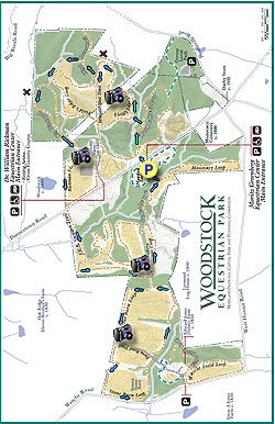
The Woodstock Equestrian Park, located near Beallsville, in
Montgomery County MD, is a multi-use 872 acre facility with over 16
miles of hiking and horse riding trails. Still farmed today, the trails
mostly follow the perimeters of rolling fields, and have beautiful views of local farmland.
George Washington originally owned a portion of the eastern side of the
park, and the area still has several structures dating back to the mid
1800s, including the Brewer Farmhouse and Seneca Stone Barn.
Note that the trails on the property are not blazed, however there are trail name signposts at most major intersections.
- Mile 0.0 – From the parking area head back towards Rt. 28 and follow the Meadow Loop Trail left for 100 yards. Leave the Meadow Loop Trail and cross Rt. 28 Darnestown Rd where there is a break in the fence at the opposite side of the road. The hike continues on the opposite side of the field next to another pedestrian horse bridge. Do Not cross the bridge, turn right following the treeline uphill to the intersection of the Potomac Hunt Loop Trail in 0.1 miles.
- Mile 0.3 - Turn left on the Potomac Hunt Loop Trail for 0.2 miles to the connector trail for the Fields Edge Loop Trail. Turn left towards the Fields Edge Loop Trail, crossing a bridge, then climbing uphill to the edge of a field and intersection of the Fields Edge Loop Trail.
- Mile 0.6 - Turn right on the Fields Edge Loop and follow the perimeter of the field. Pass under power lines, then follow the perimeter of an adjacent field. At the corner of this field is a trail that connects to private property. Continue along the perimeter back to the main field and pass the Straight Shot Trail on the left.
- Mile 1.5 - Shortly after passing this intersection turn right onto the High Point Trail. Follow the High Point Trail for 0.1 miles to a connector trail and kiosk. Turn left on the connector then arrive at another field. Turn right following the perimeter of the field, descend through a small gully, then rejoin the Fields Edge Loop. Stay right following the field perimeter to the next trail intersection.
- Mile 2.0 - Turn right on the connector trail to the Big Woods Loop Trail, then in 100 yards arrive at the Big Woods Loop Trail. Turn right following the Big Woods Loop Trail as it passes an old Meteor, then a side trail to private property. Continue now slightly uphill passing two more trail intersections before passing through a power line clear-cut. The trail reenters the woods for 200 yards, then enters a small field and arrives at the Rickman Field Loop Trail. Turn right on the Rickman field Loop as it follows the right side of a large field with views of a riding ring. continue to where the trail crosses Rt.28.
- Mile 3.1 - Cross Rt. 28 Darnestown Rd., and follow the gravel road (J.E.B. Stewart Trail) through a low area and over a small creek. The gravel road then climbs and passes the first trail marker for the Greenberg Challenge Loop Trail. Continue on the gravel road for another 250ft to the ridge and top marker for the Greenberg Challenge Loop Trail, located just after an old farmhouse.
- Mile 3.5 - Turn left following the treeline with views of two fields, and in 0.9 miles arrive at the connector trail for the Stone Barn Loop Trail.
- Mile 4.2 - Turn right into the treeline passing a kiosk, then reach the trail marker for the Stone Barn Loop Trail as you exit the trees.
- Mile 4.3 - Turn right following the treeline, staying on the trail as it turns left at the field corner. Walk along the left side of the property fence and cross the Farm Road Trail. After crossing the Farm Road Trail continue along the fields edge towards Wasche Rd.
- Mile 5.2 - Just before arriving at Wasche Rd. turn left following the field boundary, and shortly arrive at Seneca Stone Barn. Continue along the trail re-crossing the Farm Road Trail and follow the field boundary for another 0.6 miles back to the start of the Stone Barn Loop Trail.
- Mile 6.4 - Pass back through the treeline to the Greenberg Challenge Loop Trail. Continue right on the Greenberg Challenge Loop Trail downhill for 0.3 miles to the intersection of the Two Bridge Trail.
- Mile 6.6 - The Two Bridge Trail will cross the first bridge, then turn left through a wetland area and pass a small pond. Exit the treeline and follow the trail along the left side of another field to the start of the Monocacy Loop Trail.
- Mile 6.7 - Turn left staying on the Two Bridge Trail, crossing a second bridge, then arrive at the junction of the Meadow Loop Trail.
- Mile 6.8 - Climb the small rise back to the kiosk and parking area.