Woodpecker Swamp at Erwin Wildlife Management Area in Erwin Post, New York is a moderate 2-mile out-and-back hike that features views and a change to see wildlife.
Hike Description
This hike begins at the junction of Smith Rd and Weaver Creek Rd. Note that most of the year, the gate along Weaver Creek Rd is closed, thus hikers must start here and follow the service road in. This hike does exactly that - follows Weaver Creek Rd (aka Erwin Wildlife Management Area service road) southeast as it initially heads up a moderately-graded hill. Along the way are a couple of trails that hikers can alternatively take that cross the service road; however, those paths simply add mileage to this hike if you wish to take those instead as they wind in and out of the road.
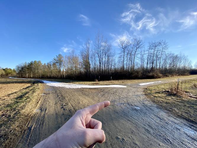
Right-Hand Turn - Mile 0.4
At mile 0.4, hikers will have reached the top of the hill where they'll find a service road that heads southwest. Take this right-hand turn. Also note that at this road junction is a trail map of the wildlife area, as of January 2023. Hikers will follow this service road for a little while as it makes its way toward the swamp.
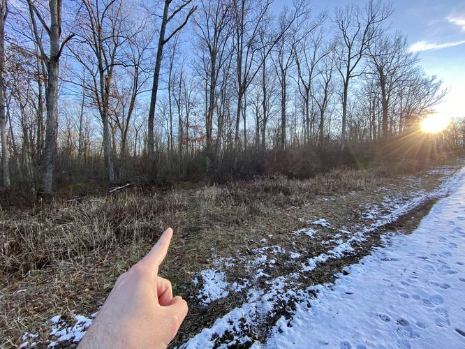
Left-Hand Turn - Mile 0.82
Around mile 0.82, hikers will reach a left-hand turn that leads along a skinny path off of the service road and back into the woods. Note that this left-hand turn is located up the hill from an off-trail service gate (and "Stop" sign). Once you see the service gate, continue along the service road and up the hill just a few-hundred more feet after the bend in the road to find this trail.
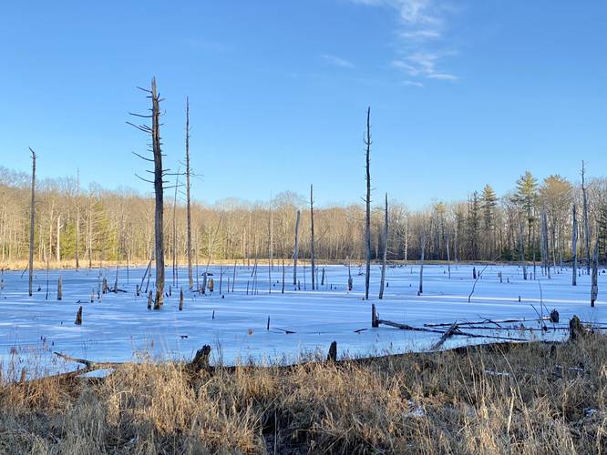
Woodpecker Swamp - Mile 1
Finally, around mile 1, hikers will find a small off-shoot trail that leads down to Woodpecker Swamp. At mile 1, hikers will reach the banks of the swamp which provide nice views of the swamp and the dead standing trees in its waters. If you're quiet enough and listen closely, you may be able to hear woodpeckers looking for food in these dead trees. From here, you can choose to continue following this trail to make a loop with the initial service road or, as this map depicts, hike this as an out-and-back. If you choose the loop, there are likely more swamp views.
Parking
Hikers will find parking at the coordinates provided at the junction of Smith Rd and Weaver Creek Rd. The lot is large enough to fit a dozen vehicles or so. Note that the service road gate that sits next to this parking lot is only open for hunting season form October 1 - December 15th each year and for "Free Fishing Weekend" which is the last weekend in June of each year.
Pets
Dogs are allowed if leashed and their waste should be carried out by the hiker.
Difficulty
This hike should be considered easy to moderate depending on the skill level of the hiker. The service road that leads in is not very steep, but follows a fairly moderate grade for the first 0.4-miles. Once on the 2nd service road, this hike becomes much easier and the way out is mostly all downhill with some short uphill sections.
Hike Description
This hike begins at the junction of Smith Rd and Weaver Creek Rd. Note that most of the year, the gate along Weaver Creek Rd is closed, thus hikers must start here and follow the service road in. This hike does exactly that - follows Weaver Creek Rd (aka Erwin Wildlife Management Area service road) southeast as it initially heads up a moderately-graded hill. Along the way are a couple of trails that hikers can alternatively take that cross the service road; however, those paths simply add mileage to this hike if you wish to take those instead as they wind in and out of the road.
Right-Hand Turn - Mile 0.4
At mile 0.4, hikers will have reached the top of the hill where they'll find a service road that heads southwest. Take this right-hand turn. Also note that at this road junction is a trail map of the wildlife area, as of January 2023. Hikers will follow this service road for a little while as it makes its way toward the swamp.
Left-Hand Turn - Mile 0.82
Around mile 0.82, hikers will reach a left-hand turn that leads along a skinny path off of the service road and back into the woods. Note that this left-hand turn is located up the hill from an off-trail service gate (and "Stop" sign). Once you see the service gate, continue along the service road and up the hill just a few-hundred more feet after the bend in the road to find this trail.
Woodpecker Swamp - Mile 1
Finally, around mile 1, hikers will find a small off-shoot trail that leads down to Woodpecker Swamp. At mile 1, hikers will reach the banks of the swamp which provide nice views of the swamp and the dead standing trees in its waters. If you're quiet enough and listen closely, you may be able to hear woodpeckers looking for food in these dead trees. From here, you can choose to continue following this trail to make a loop with the initial service road or, as this map depicts, hike this as an out-and-back. If you choose the loop, there are likely more swamp views.
Parking
Hikers will find parking at the coordinates provided at the junction of Smith Rd and Weaver Creek Rd. The lot is large enough to fit a dozen vehicles or so. Note that the service road gate that sits next to this parking lot is only open for hunting season form October 1 - December 15th each year and for "Free Fishing Weekend" which is the last weekend in June of each year.
Pets
Dogs are allowed if leashed and their waste should be carried out by the hiker.
Difficulty
This hike should be considered easy to moderate depending on the skill level of the hiker. The service road that leads in is not very steep, but follows a fairly moderate grade for the first 0.4-miles. Once on the 2nd service road, this hike becomes much easier and the way out is mostly all downhill with some short uphill sections.