Loading...

๐ŸŽ‰ Enjoy a Free 7-Day Supporter Trial and Unlock Exclusive Perks โ€” No Credit Card Required. Learn more.

Wintergreen Falls

Directions
Map
Pictures
Send to App
Distance:
0.1 Miles / 0.2 km
Type:
Out-and-Back
Difficulty:
Easy
Time to Hike:
~5 minutes
Features:
Surface Type:
Dirt
Park:
Wintergreen Park
Town:
Canajoharie, New York
Directions:
42.884762, -74.565958
Added:
August 26, 2023
Updated:
August 31, 2023
Copy Trail Link Hiking this trail? Send a friend or family member a link to this trail guide for your own safety. Hike at your own risk (disclaimer)
Loading...
Loading...
19'

Total Change
21'

Ascent
21'

Descent

Download the Trail Route for Offline Use

Supporters get exclusive access to download trail routes to the MyHikes app for offline use. Stay prepared on your adventure, even without an internet connection! Become a Supporter today to unlock this feature and hike with confidence.

Send to App

Wintergreen Falls

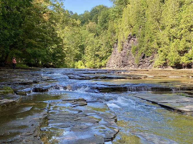
Wintergreen Falls at Wintergreen Park in Canajoharie, New York is a 0.1-mile out-and-back hike that features a beautiful creek swimming hole and a small 3-foot tall 50-foot long waterfall that cascades down series of bedrock.

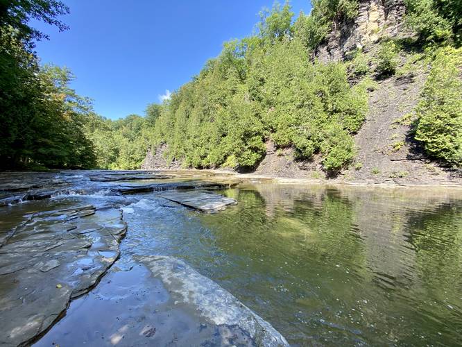
This is not a hike but rather a short walk from the lower parking area at Wintergreen Park that leads out along the banks of Canajoharie Creek. Hikers will find steep gorge walls made-up of shale and limestone that tower overhead on the northern side of the creek. In the creek, hikers will find the small, but long, Wintergreen Falls. Below the waterfall is a deep swimming hole that visitors can use to cool down.

Parking
Hikers will find parking at Wintergreen Park near the coordinates provided. Note that the parking coordinates and trailhead start at the very-bottom of Wintergreen Park - so follow the road to reach the creek. Alternatively, hikers can park at the very-top of Wintergreen Park and hike down and back for some real exercise if they wish.

Pets
Dogs are allowed only if leashed and must be cleaned up after.

Warnings
Flash flooding: This creek is known to flash flood from time to time. Pay attention to the weather and if the water level begins to rise (if swimming) get out immediately.

Falling rock: The gorge surrounding Canajoharie Creek is made-up of steep shale and limestone, both of which fall from the ledges from time to time which sends rocks flying into the creek below. This could happen at any time without warning, so watch out.
Explore 3 trails near Canajoharie, NY
  1. Parking

    42.884762, -74.565958
  2. Main Trailhead

    42.884849, -74.565927
  3. Wintergreen Falls (3-feet tall, 50-feet long)

    42.885273, -74.565175
    Wintergreen Falls (3-feet tall, 50-feet long)
  4. Canajoharie Creek swimming hole

    42.885309, -74.56511
    Canajoharie Creek swimming hole
No community routes found. To add your own hike as a Community Route for this Trail guide, leave a Trip Report with an attached GPX file.

Hazards

Ticks - Lyme Disease More Info (CDC)
Poison Ivy/Oak
Rockfalls / Ledges / or Scrambles

Seasons

All

Weather Forecast

In Canajoharie, NY

Explore Hiking Trails

You May Also Like

Colorado's Million Dollar Highway - Plan a day's drive adventure along the iconic Million Dollar Highway in Colorado. Explore the best short trails, roadside stops, waterfalls, vistas, ghost towns, and hot springs within a ~6 hour road trip.
Explore

Colorado's Million Dollar Highway

Plan a day's drive adventure along the iconic Million Dollar Highway in Colorado. Explore the best short trails, roadside stops, waterfalls, vistas, ghost towns, and hot springs within a ~6 hour road trip.

Read
Glacier's Going-to-the-Sun Road - Discover the breathtaking beauty of Glacier National Park along the iconic Going-to-the-Sun Road. From stunning roadside stops to picturesque waterfalls and vistas, this engineering marvel offers endless opportunities for exploration.
Explore

Glacier's Going-to-the-Sun Road

Discover the breathtaking beauty of Glacier National Park along the iconic Going-to-the-Sun Road. From stunning roadside stops to picturesque waterfalls and vistas, this engineering marvel offers endless opportunities for exploration.

Read
New York's Best Waterfalls - Whether you're planning a day hike, roadside stop, or a leisurely short walk, this guide provides hikers, travelers, and locals alike with 63 different locations to over 100 scenic waterfalls to help plan your next adventure!
Explore

New York's Best Waterfalls

Whether you're planning a day hike, roadside stop, or a leisurely short walk, this guide provides hikers, travelers, and locals alike with 63 different locations to over 100 scenic waterfalls to help plan your next adventure!

Read

Before you boogie...

Find our trail guides useful? Consider becoming a Supporter to unlock perks!

MyHikes is an indie platform that makes exploring public trails easier for everyone. The platform has no investors, no ads, and is owned and operated by one person, Dave Miller. Dave has personally mapped and written over 1,800 trail guides on MyHikes for the public to explore. MyHikes has helped millions outdoor enthusiasts plan their next adventure.

But it takes a lot of time ๐Ÿ•ฆ, money ๐Ÿ’ฐ, work, and espresso shots โ˜• to run MyHikes, including hiking , mapping , writing , and publishing new trails with high-quality (accurate) information... along with software engineering (coding) the platform like building new features, website and mobile app development (iOS and Android), site maintainance . and much much more.

Supporters unlock website and mobile app perks with an annual one-time payment of $25 (you renew) ๐Ÿ˜Ž๐Ÿ‘. Or you can simply make a Donation of your choice. Otherwise, you can support us by telling your friends about MyHikes - both quick and free ๐ŸŽ‰

Admin user profile picture

Dave Miller
MyHikes Founder