Loading...

WINTER SALE! 50% OFF Supporter Accounts — now through January 31st. Learn More.

Wildlife Trail

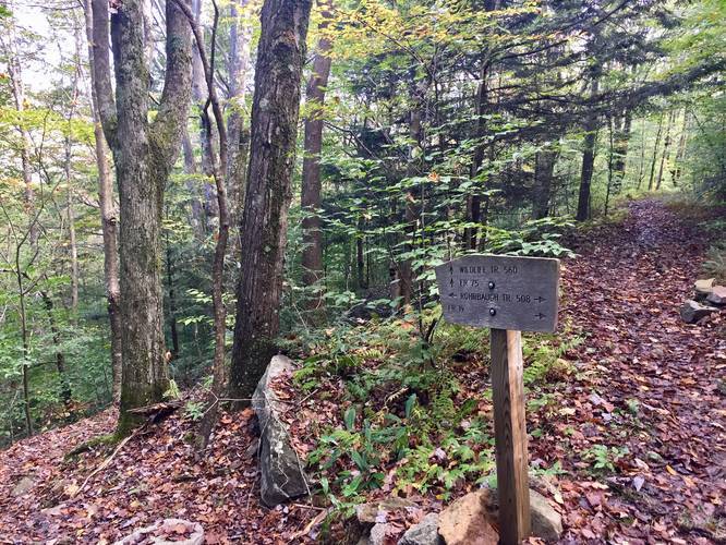
The Wildlife Trail (TR-560) at Dolly Sods Wilderness in West Virginia is an easy 3 mile out-and-back hike that connects FR-75 to the Rohrbaugh Plains Trail (TR-508). You can use this trail to reach Red Creek via Rohrbaugh Plains as well.

Just after the trailhead, you'll find a fork in the trail - stay right to keep on the Wildlife Trail; otherwise, you'll end up hiking through a field and into a dead end.

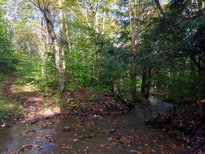
Further into the hike you'll pass another field, about 1 mile in, before the trail ends at the Rorhbaugh Plains Trail. You'll pass a few creeks that cross the trail and along the way as well, so you can filter this water if necessary.

Wildflowers can be found in the late Spring and throughout the Summer. Foliage during autumn is nice too, but there are no blueberry bushes along this trail like in the northern part of the Sods.

Muddy: This trail is abnormally muddy after a it rains. If it's been raining all week, plan for a messy muddy hike almost the entire distance.

Camping: While there is nowhere to camp along this trail, the trail does lead into more primitive backpacking sites within Dolly Sods.
Explore 49 trails near Dolly Sods Wilderness, WV

Know Before You Go

  • Wildlife Trail (TR-560) is an easy 3-mile out-and-back trail in Dolly Sods Wilderness connecting FR-75 to Rohrbaugh Plains Trail (TR-508), offering access to Red Creek.
  • The trail is generally easy to navigate, but watch for an initial fork (stay right) and be prepared for potential muddy conditions, especially after rain.
  • While there are no campsites directly on the Wildlife Trail, it provides access to backpacking sites within Dolly Sods, and wildflowers can be seen during spring and summer.
Interactive topographic map for Wildlife Trail located in Dolly Sods Wilderness, WV. Click the "View Map" button to load GPS coordinates and trail markers.
Get directions
Distance
3.0 mi
Difficulty
Easy
Type
Out-and-Back
Est. Time
1.5 hrs
Elev. Gain
455'
Rating
0.0
Added
October 07, 2018
Updated
October 25, 2018

Weather Forecast

Loading...
Total Change
455'
Ascent
455'
Descent
455'
Loading...

Download the GPX Data for Offline Use

Supporters get exclusive access to download trail routes to the MyHikes app for offline use. Stay prepared on your adventure, even without an internet connection! Become a Supporter today to unlock this feature and hike with confidence.

Download Wildlife Trail GPX Data to the MyHikes Mobile App

Features

Dogs
Camping
Water Source

Points of interest

  1. Parking

    38.986801, -79.329572
  2. Main Trailhead

    38.986743, -79.329538

Safety information

For your own safety: plan ahead, let someone know where you'll be, and hike at your own risk.

Availability

All seasons

Surface type

Dirt

Trip Reports (Reviews)

Your opinion matters! Be the first to rate this trail.

Ready to help fellow hikers? Add a trip report to share your experience and provide valuable insights for other hikers!

2.0 miles / 3.2 km
October 06, 2018
Too muddy
Dogs Hiking
No community routes found. To add your own hike as a Community Route for this Trail guide, leave a Trip Report with an attached GPX file.

Popular categories

Scenic mountain view representing vista trails
Vista trails
Scenic gorge of cascades representing waterfall trails
Waterfall hikes
Rugged mountain terrain representing summit trails
Summit trails
Scenic mountain view representing dog-friendly trails
Dog-friendly
Scenic campsite with a view representing camping trails
Camping trails
Appalachian Trail logo representing A.T. hikes
A.T. hikes

You May Also Like

Colorado's Million Dollar Highway - Plan a day's drive adventure along the iconic Million Dollar Highway in Colorado. Explore the best short trails, roadside stops, waterfalls, vistas, ghost towns, and hot springs within a ~6 hour road trip.
Explore

Colorado's Million Dollar Highway

Plan a day's drive adventure along the iconic Million Dollar Highway in Colorado. Explore the best short trails, roadside stops, waterfalls, vistas, ghost towns, and hot springs within a ~6 hour road trip.

Read
🍪 We use cookies to learn about site usage and to serve map tiles. You may block cookies manually in the browser. By continuing you agree. Learn more