Exploring the Susquehannock Trail System near Austin, Pennsylvania is the trace recording of this hike, which is a moderate 4.5-mile loop. The Susquehannock Trail System is an 85-mile loop hiking trail in Potter County in north-central Pennsylvania in the Susquehannock State Forest . This hike stretches across the Wild Boy. The Wild Boy, inspired by legend of a Potter County Wild Boy who once lived here, lies within the Susquehannock State Forest and is known for its beautiful forests and small streams.
The trekker starts on the Tower Trail for a moderate walk, with a 1.5 mile gradual descent to the Wild Boy Shelter at the head of Wild Boy Run followed by a 1.5 mile gradual ascent on the Wild Boy Trail to the ridge above Birch Run Hollow. To complete the loop, the hiker turns right to follow the mostly-flat unmarked logging road at the head of Birch Run Hollow for 0.6 miles to the Nelson Run Road. At the Nelson Run Road, the hiker can turn right to follow this forestry road back to the Wild Boy Road Parking area. There is a vista look-out along the Nelson Run Road near to the intersection with the Wild Boy Road, which was likely once the location a Fire Tower. Fire towers were common in Pennsylvania in the early 1900s as the primary way for spotting wildfires.
While on the STS, the hiker may opt to simply turn around and trek back to parking area on the STS in the reverse direction as an out-and back hike. The STS is well marked and well maintained by the Susquehannock Trail Club (STC). STC is the care takers of the STS and schedules a variety of hikes from April through October.
Trails
The trails along this route include the Tower Trail, Upper part of Wild Boy Trail, an unnamed state forest logging road and the Nelson Run Forestry Road at the head of Wild Boy Hollow.
Look for updates as the lower section of Wild Boy Run is traced and uploaded in the near future to give additional trails for hikers to explore in the Wild Boy of Potter County.
Length and Difficulty
The difficulty should still be considered moderate because of the elevation gain along the path. The trail covers a variety of terrain types. Trekkers should keep the trail distance in mind and within their endurance abilities.
Parking
Hikers can find parking at the coordinates provided; next to the trailhead, along Wild Boy Road. It is important not park in front of the gate across the State Forest Access Road, which would block authorized vehicles from using the state forest road.
Pets
Dogs are allowed if leashed.
Camping and Backpacking
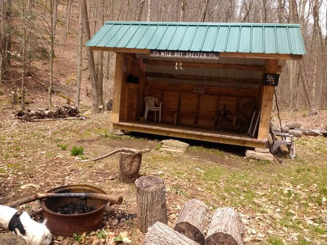
Backpackers are allowed to camp off-trail only within the Susquehannock State Forest along this route. Backpackers need to follow the state forest rules and regulations for dispersed / primitive / backcountry camping. The STS Wild Boy Shelter at the head of Wild Boy Run provides the best camping opportunity. The STC builds and maintains these shelters. The shelters on the STS are placed with preference toward and to give a comfortable stay for those thru-hikers doing an end-to-end hike.
Water Source
Hikers can use water filters along the adjacent creeks along this hike at the lower elevations.
A nature spring cascades on a rock outcropping near by STS Wild Boy Shelter.
The trekker starts on the Tower Trail for a moderate walk, with a 1.5 mile gradual descent to the Wild Boy Shelter at the head of Wild Boy Run followed by a 1.5 mile gradual ascent on the Wild Boy Trail to the ridge above Birch Run Hollow. To complete the loop, the hiker turns right to follow the mostly-flat unmarked logging road at the head of Birch Run Hollow for 0.6 miles to the Nelson Run Road. At the Nelson Run Road, the hiker can turn right to follow this forestry road back to the Wild Boy Road Parking area. There is a vista look-out along the Nelson Run Road near to the intersection with the Wild Boy Road, which was likely once the location a Fire Tower. Fire towers were common in Pennsylvania in the early 1900s as the primary way for spotting wildfires.
While on the STS, the hiker may opt to simply turn around and trek back to parking area on the STS in the reverse direction as an out-and back hike. The STS is well marked and well maintained by the Susquehannock Trail Club (STC). STC is the care takers of the STS and schedules a variety of hikes from April through October.
Trails
The trails along this route include the Tower Trail, Upper part of Wild Boy Trail, an unnamed state forest logging road and the Nelson Run Forestry Road at the head of Wild Boy Hollow.
Look for updates as the lower section of Wild Boy Run is traced and uploaded in the near future to give additional trails for hikers to explore in the Wild Boy of Potter County.
Length and Difficulty
The difficulty should still be considered moderate because of the elevation gain along the path. The trail covers a variety of terrain types. Trekkers should keep the trail distance in mind and within their endurance abilities.
Parking
Hikers can find parking at the coordinates provided; next to the trailhead, along Wild Boy Road. It is important not park in front of the gate across the State Forest Access Road, which would block authorized vehicles from using the state forest road.
Pets
Dogs are allowed if leashed.
Camping and Backpacking
Backpackers are allowed to camp off-trail only within the Susquehannock State Forest along this route. Backpackers need to follow the state forest rules and regulations for dispersed / primitive / backcountry camping. The STS Wild Boy Shelter at the head of Wild Boy Run provides the best camping opportunity. The STC builds and maintains these shelters. The shelters on the STS are placed with preference toward and to give a comfortable stay for those thru-hikers doing an end-to-end hike.
Water Source
Hikers can use water filters along the adjacent creeks along this hike at the lower elevations.
A nature spring cascades on a rock outcropping near by STS Wild Boy Shelter.