Loading...

🔥 End of Summer sale! 50% off on Supporter Accounts — now through September 1st. Learn More.

White Oak Canyon and Cedar Run Hike

Directions
Map
Pictures
Send to App
Distance:
7.7 Miles / 12.4 km
Type:
Loop
Difficulty:
Hard
Time to Hike:
3 hours, ~51 minutes
Features:
Surface Type:
Dirt
Park:
Shenandoah National Park
Town:
Syria, Virginia
Directions:
38.538848, -78.347947
Added:
March 19, 2025
Updated:
April 06, 2025
Guide by:
Copy Trail Link Hiking this trail? Send a friend or family member a link to this trail guide for your own safety. Hike at your own risk (disclaimer)
Loading...
Loading...
2,234'

Total Change
2,421'

Ascent
2,415'

Descent

Download the Trail Route for Offline Use

Supporters get exclusive access to download trail routes to the MyHikes app for offline use. Stay prepared on your adventure, even without an internet connection! Become a Supporter today to unlock this feature and hike with confidence.

Send to App

White Oak Canyon and Cedar Run Hike

This hike has some of the most spectacular waterfalls in the Shenandoah National Park. Combining two out-and-back hikes, White Oak Canyon & Cedar Run, this loop starts at the bottom of the valley and cuts over near the top of the ridge. With five major falls, numerous smaller cascades and pools, this circuit hike is one of the best.

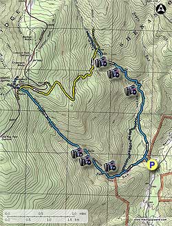
Begin up the blue blazed White Oak Canyon (WOC) Trail, at the top of the upper parking area next to the SNP ranger station. Shortly cross a steel footbridge, then arrive at the intersection of the Cedar Run Trail that will be your return route. Stay straight on the WOC Trail as it winds to the right, then crosses another steel footbridge over WOC Run.

Follow the blue blazed trail on the right side of WOC Run reaching the WOC/Cedar Run Connector Trail in 0.6 miles. Stay straight on the right side of WOC Run for another 0.7 miles, cross a small stream, then arrive the base of the first set of major falls.

The trail will now make several switchbacks as the grade gets steeper, then reaches the second set of falls in 0.6 miles. Again, the trail will switchback several times, then become less steep, and arrive at a concrete marker for the base of the main WOC falls. To see the falls from the base, follow the side trail straight for 100 yards. Continue uphill on the WOC Trail as it steeply climbs the last 0.1 miles to the main WOC falls overlook.

Continuing uphill from the main overlook, and shortly arrive at the yellow blazed Bridge Path Trail that comes in from the right. Stay straight, then cross WOC Run in another 40 yards at the horse rail. If WOC Run is high, continue up the right side of WOC Run and cross a footbridge in 120 yards.

After crossing the run follow the wide yellow blazed WOC Fire Road/Horse Trail. In 1.6 miles the WOC Fire Road/Horse Trail will veer right. Stay left on the narrower yellow blazed trail, marked on a concrete post as "Horse Tr To Big Meadows". In 0.6 miles the horse trail intersects the blue blazed Cedar Run Trail.

Turn left downhill on the blue blazed Cedar Run Trail, then in 1.3 miles cross Cedar Run. In 0.2 miles after crossing Cedar Run reach the top set of main falls at Halfmile Cliff known as "The Slide". 60 yards below the main falls is a pool where Cedar Run passes through a narrow gorge.

Continue downward on the Cedar Run Trail for 0.5 miles where the blue blazed trail makes a sharp left to cross Cedar Run for the last time. After crossing Cedar Run follow the trail for 0.3 miles to the intersection of the WOC/Cedar Run Connector Trail. Turn right downhill on the Cedar Run Trail towards RT600, and in 0.4 miles arrive back at the WOC Trail intersection. Turn right, re-cross the steal footbridge, and arrive back at the parking area.
Explore 78 trails near Syria, VA
  1. Parking

    38.538848, -78.347947
  2. Main Trailhead

    38.539539, -78.349257
No community routes found. To add your own hike as a Community Route for this Trail guide, leave a Trip Report with an attached GPX file.

Hazards

Ticks - Lyme Disease More Info (CDC)
Snakes
Poison Ivy/Oak

Seasons

All

Trip Reports (Reviews)

Rated 4.42 out of 5 based on 229 ratings.
By: Luanne
7.7 miles / 12.4 km
October 01, 2019
As we were approaching the parking area, there was a sign posted about 3 miles away "White Oak Trail Closed". The inside the car immediately became quiet. Apparently, they are replacing a bridge right next to the parking area. This was closed beginning Sept 15 and don't know when it will reopen. You are now forewarned.
Legacy Review
By: Erin
7.7 miles / 12.4 km
July 21, 2019
I hiked this circuit with my dog on Sunday - which also happened to be one of the hottest days of the year! We parked at the Hawksbill Summit/Cedar run parking inside the park. At 10am there were still spots left but it filled up quickly. We started down the Cedar Run trail and mostly had the trail to ourselves until the lower falls. I agree with other reviewers that this trail is more 'rustic'. There were a lot more rocky areas to scramble over and tree branches in the path. I was definitely glad to have good hiking boots on! In several places we had to jump over fallen trees and sometimes it was hard to know where the trail continued because the fallen trees obscured it. Fortunately my dog can smell where other people went and let the way! At the falls, we encountered a few other hikers/bathers, but just a few. They had come up from the lower parking lot and since it is a MUCH tougher climb to the Ceder Run falls (as opposed to the White Oak falls), very few come up that way. Its nice if you prefer a quieter hike. In some cases, we had the falls all to ourselves, even on a hot Sunday in July! After descending Cedar Run, we took the link trail over to White Oak. At some point we lost the marked trail and had to ford a river in the absence of any marking. I could see hikers on the other side going up White Oak but could not find the path. We scrambled up a muddy bank on the far side which would not have been passable in the rain. We then took White Oak all the way back up to the Fire Road, stopping at various falls. The White Oak falls were all pretty crowded as they are popular bathing areas. We saw a copperhead snake on the trail at one point...and others saw copperheads too...so be careful with kids and dogs. We took the Fire Road/Bridal Trail back over to Cedar Run, at which point it began raining buckets. Fortunately the Fire Road is an easy path and we made it back to the car where dry clothes and cold drinks were waiting. All in all, it was about 7.5 hours and pretty strenuous, but a great sense of accomplishment when we completed it!
Legacy Review
By: Alan from DC
7.7 miles / 12.4 km
April 20, 2019
Parking lot was at 10:15am when we arrived. We ended up parking at the private overflow lot and paid the guy $10. There were two cars there at the lot when we arrived. So you might luck out with a free spot before 10. This like old rag now where you have to pay $10 to park in the overflow lot. There’s no White Oak Canyon loop on the free map so we ended up hiking all the way up and down the Appalachian trail back to Cedar Run instead of taking the shortcut across using the fire road to Cedar Run. Wife was not too happy about my poor research on this hike. The water were strong and high during our hike. We had to wade over the river at multiple places. Our hiking boots were wet from it. We should have taken it off. The views were pretty nice but I enjoyed the waterfalls on the cedar run side more.
Legacy Review

Weather Forecast

In Syria, VA

Explore Hiking Trails

You May Also Like

New York's Best Waterfalls - Whether you're planning a day hike, roadside stop, or a leisurely short walk, this guide provides hikers, travelers, and locals alike with 63 different locations to over 100 scenic waterfalls to help plan your next adventure!
Explore

New York's Best Waterfalls

Whether you're planning a day hike, roadside stop, or a leisurely short walk, this guide provides hikers, travelers, and locals alike with 63 different locations to over 100 scenic waterfalls to help plan your next adventure!

Read
25 Best Day Hikes in North Carolina - Discover the top 25 best day hikes in North Carolina, from breathtaking waterfalls to mountain peaks. Explore hidden gems, scenic views, and trails suitable for all skill levels, perfect for your next outdoor adventure.
Explore

25 Best Day Hikes in North Carolina

Discover the top 25 best day hikes in North Carolina, from breathtaking waterfalls to mountain peaks. Explore hidden gems, scenic views, and trails suitable for all skill levels, perfect for your next outdoor adventure.

Read

Before you boogie...

Find our trail guides useful? Consider becoming a Supporter to unlock perks!

MyHikes is an indie platform that makes exploring public trails easier for everyone. The platform has no investors, no ads, and is owned and operated by one person, Dave Miller. Dave has personally mapped and written over 1,800 trail guides on MyHikes for the public to explore. MyHikes has helped millions outdoor enthusiasts plan their next adventure.

But it takes a lot of time 🕦, money 💰, work, and espresso shots ☕ to run MyHikes, including hiking , mapping , writing , and publishing new trails with high-quality (accurate) information... along with software engineering (coding) the platform like building new features, website and mobile app development (iOS and Android), site maintainance . and much much more.

Supporters unlock website and mobile app perks with an annual one-time payment of $25 (you renew) 😎👍. Or you can simply make a Donation of your choice. Otherwise, you can support us by telling your friends about MyHikes - both quick and free 🎉

Admin user profile picture

Dave Miller
MyHikes Founder