Whispering Pines Lake at State Game Lands 64 near Galeton, Pennsylvania is an easy 3.4-mile out-and-back hike that leads to the large swamp known as Whispering Pines Lake (aka Bristol Swamp).
Hike Description
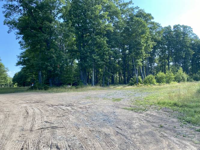
This hike begins at the end of Ansley Road just north of Galeton, PA at the site of an old fire tower; however, as of August 2022, there appears to be no remaining structures from the fire tower that were visible from the parking area. Hikers must walk-in from the parking area, despite many local hunters disregarding signs and driving in anyway as the trail follows a well-defined and wide service road that provides about 50% shade cover during the morning or late afternoon. During mid-day, there's not much shade along this hike.
The trail starts off by heading downhill a ways before it levels out. The tree species around the trail, in the beginning of the hike, are deciduous - a mix of pretty much every hardwood known to north-central Pennsylvania, but hikers may notice the Aspen trees along the route too - their silver-backed, circular leaves shine in the light and ruffle as the wind blows.
Right-hand Turn - Mile 0.93
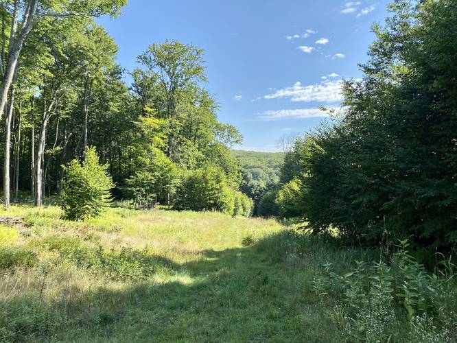
At mile 0.93, hikers will reach a large junction in the service road with a loosely-defined right-hand turn (usually overgrown during the Summer) that follows a grassy service road out to Whispering Pines Lake. Take this right-hand turn and follow the trail as it undulates its way downhill toward the swamp. After taking a right-hand turn, hikers will pass through several groves of White Pine trees, which changes the look and feel of the trail.
Hillside View - Mile 1.45
At mile 1.45, along the last downhill slope, hikers will reach a small view point of the surrounding hills located directly ahead. While this view is nothing spectacular, it's a nice change of scenery along the hike.
Whispering Pines Lake - Mile 1.65 to 1.72
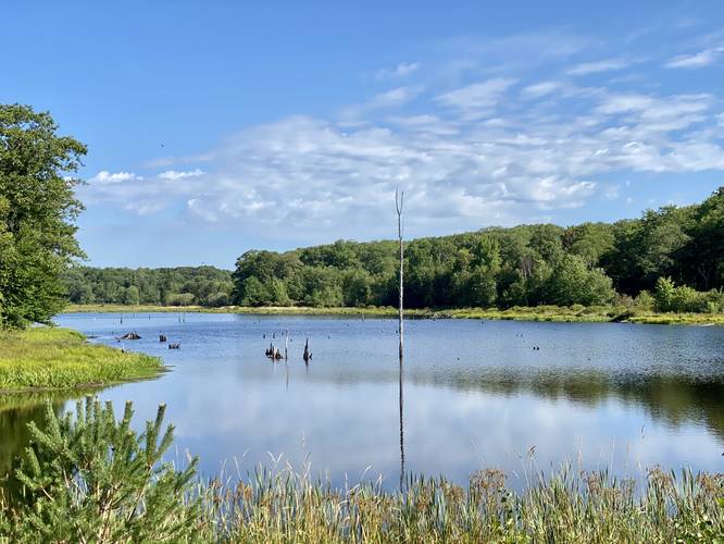
Finally, around mile 1.65, hikers will reach the southwest corner of Whispering Pines Lake (aka Bristol Swamp). The trail follows a dike that stretches the entire southern length of the swamp, which allows hikers to enjoy more views of this large body of water. On the southern side of this dike is another swamp area, but it sees far less water than the north side - which is controlled by a concrete water intake box that then passes it under the structure to the other side. The southern side of the swamp creates Johnson Brook. This track ends at the southeastern corner, but there's a service road (technically the Phoenix Trail) that runs the eastern length of the water. Upon our first visit here, we found two large birds flying over the water as we approached - possibly a turkey vulture and one large Great Blue Heron. We also observed many different smaller birds flying around or perched in the dead trees located in the swamp itself. During mid-August 2022, the bugs were surprisingly not bad at all, making this a nice place to setup a chair to watch nature. The southern end of the swamp has some well-defined Aspen trees too, so in the Fall, this area must be popping with color with foliage alongside the blue water and skies.
Hiking Out
While the hike out is not difficult, it's also not super easy either as you have to make your way back uphill. Most of the walking should be considered easy with small 'moderate' hills walks in between. Overall, this hike is not difficult.
Prohibited
No horses. No biking. No camping. No driving beyond the parking lot.
Parking
Hikers will find parking at the coordinates provided at the site of an old fire tower (which has been dismantled long ago). The turnout is large enough to fit about 12 vehicles if necessary and allows foot access to State Game Lands 64 (SGL 64 / S.G.L. 64).
Warning
Hunting: State Game Lands allow hunting and exist almost solely for the purpose of hunting, despite the fact that hikers can and do explore these public lands. Hunters wear blaze orange to stay safe and so should you.
Timer Rattlesnake: This area is known to inhabit the Timber Rattlesnake and while there may or may not be any rattler dens located nearby, hikers may encounter one on the trail - sunning itself in the tall grass or near bodies of water to hunt. Be on the lookout between the end of April and early October to ensure you don't step on one.
Names
The swamp is also called Bristol Swamp in Chuck Dillon's book, Short Hikes in God's Country (1995).
Hike Description
This hike begins at the end of Ansley Road just north of Galeton, PA at the site of an old fire tower; however, as of August 2022, there appears to be no remaining structures from the fire tower that were visible from the parking area. Hikers must walk-in from the parking area, despite many local hunters disregarding signs and driving in anyway as the trail follows a well-defined and wide service road that provides about 50% shade cover during the morning or late afternoon. During mid-day, there's not much shade along this hike.
The trail starts off by heading downhill a ways before it levels out. The tree species around the trail, in the beginning of the hike, are deciduous - a mix of pretty much every hardwood known to north-central Pennsylvania, but hikers may notice the Aspen trees along the route too - their silver-backed, circular leaves shine in the light and ruffle as the wind blows.
Right-hand Turn - Mile 0.93
At mile 0.93, hikers will reach a large junction in the service road with a loosely-defined right-hand turn (usually overgrown during the Summer) that follows a grassy service road out to Whispering Pines Lake. Take this right-hand turn and follow the trail as it undulates its way downhill toward the swamp. After taking a right-hand turn, hikers will pass through several groves of White Pine trees, which changes the look and feel of the trail.
Hillside View - Mile 1.45
At mile 1.45, along the last downhill slope, hikers will reach a small view point of the surrounding hills located directly ahead. While this view is nothing spectacular, it's a nice change of scenery along the hike.
Whispering Pines Lake - Mile 1.65 to 1.72
Finally, around mile 1.65, hikers will reach the southwest corner of Whispering Pines Lake (aka Bristol Swamp). The trail follows a dike that stretches the entire southern length of the swamp, which allows hikers to enjoy more views of this large body of water. On the southern side of this dike is another swamp area, but it sees far less water than the north side - which is controlled by a concrete water intake box that then passes it under the structure to the other side. The southern side of the swamp creates Johnson Brook. This track ends at the southeastern corner, but there's a service road (technically the Phoenix Trail) that runs the eastern length of the water. Upon our first visit here, we found two large birds flying over the water as we approached - possibly a turkey vulture and one large Great Blue Heron. We also observed many different smaller birds flying around or perched in the dead trees located in the swamp itself. During mid-August 2022, the bugs were surprisingly not bad at all, making this a nice place to setup a chair to watch nature. The southern end of the swamp has some well-defined Aspen trees too, so in the Fall, this area must be popping with color with foliage alongside the blue water and skies.
Hiking Out
While the hike out is not difficult, it's also not super easy either as you have to make your way back uphill. Most of the walking should be considered easy with small 'moderate' hills walks in between. Overall, this hike is not difficult.
Prohibited
No horses. No biking. No camping. No driving beyond the parking lot.
Parking
Hikers will find parking at the coordinates provided at the site of an old fire tower (which has been dismantled long ago). The turnout is large enough to fit about 12 vehicles if necessary and allows foot access to State Game Lands 64 (SGL 64 / S.G.L. 64).
Warning
Hunting: State Game Lands allow hunting and exist almost solely for the purpose of hunting, despite the fact that hikers can and do explore these public lands. Hunters wear blaze orange to stay safe and so should you.
Timer Rattlesnake: This area is known to inhabit the Timber Rattlesnake and while there may or may not be any rattler dens located nearby, hikers may encounter one on the trail - sunning itself in the tall grass or near bodies of water to hunt. Be on the lookout between the end of April and early October to ensure you don't step on one.
Names
The swamp is also called Bristol Swamp in Chuck Dillon's book, Short Hikes in God's Country (1995).