Loading...

🍂 Prep for Fall! Unlock exclusive features to plan your perfect late-summer and autumn hikes — become a Supporter today. Learn more.

Whetstone Ridge Hike

Directions
Map
Pictures
Send to App
Distance:
11.4 Miles / 18.3 km
Type:
One-Way
Difficulty:
Strenuous
Time to Hike:
5 hours, ~42 minutes
Features:
Surface Type:
Dirt
Park:
George Washington National Forest
Town:
Vesuvius, Virginia
Directions:
37.869501, -79.148143
Added:
February 17, 2025
Updated:
April 05, 2025
Guide by:
Copy Trail Link Hiking this trail? Send a friend or family member a link to this trail guide for your own safety. Hike at your own risk (disclaimer)
Loading...
Loading...
1,777'

Total Change
1,900'

Ascent
3,533'

Descent

Download the Trail Route for Offline Use

Supporters get exclusive access to download trail routes to the MyHikes app for offline use. Stay prepared on your adventure, even without an internet connection! Become a Supporter today to unlock this feature and hike with confidence.

Send to App

Key Takeaways

  • The Whetstone Ridge Trail is a challenging 11.4-mile hike near Vesuvius, VA, requiring a car shuttle.
  • The trail offers rewarding views of mountains and the Shenandoah Valley, but features a strenuous "roller coaster" section with steep elevation changes.
  • Hikers should use current trail maps (PATC Map #13) due to a Forest Service rerouting; older maps are inaccurate.

Whetstone Ridge Hike

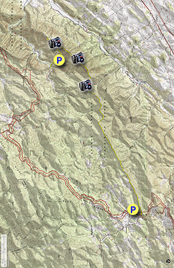
The Whetstone Ridge Trail is a tough ridgetop trail that requires a 25 minute (9.3 mile) car shuttle each way down twisty Irish Creek Road. Although the trail’s first several miles are level, after five miles the trail begins a “roller coaster” section, steeply gaining elevation then losing it just as fast multiple times before taking a sharp left and steadily descending to the trail’s end on Irish Creek Road. The trail rewards the hiker for this effort with multiple wonderful views of mountains to the east and the Shenandoah Valley to the west along much of the journey. There were no campsites visible along this hike, but several flat spots provide potential for Leave No Trace camping.

Note: The Forest Service changed the route of the southernmost section of this hike about 10 years ago. Older trail maps (including the 2007 revision of Trails Illustrated #789, current as of this writing in 2017) are incorrect and following them could mean you finish this hike nowhere near your car! For a complete set of area trails we recommend the current PATC Map #13, which is more current.

  • Mile 0.0 – The yellow blazed trail starts behind a brown hiker sign on the north end of a large parking area along the Blue Ridge Parkway. The building here has flush toilets.

  • Mile 0.2 – After passing a kiosk, the trail heads north for 0.2 mile paralleling the Blue Ridge Parkway before taking a sharp left onto Whetstone Ridge. Shortly after this turn is the high point on this hike, 3150 feet. After the summit, the trail leaves the ridge and travels along the side of the slope.

  • Mile 2.2 – Trail merges onto a woods road, as marked by a yellow trail sign.

  • Mile 2.5 – Trail splits right off of woods road, as marked by another yellow sign.

  • Mile 2.7 – After briefly merging again with the same woods road, the trail again splits right off of the woods road as marked by a yellow sign.

  • Mile 3.4 – The trail ascends a steep section, which is a precursor for what is to come. Along the way for the 0.7 mile, you may see “Posted No Trespassing” signs to the left. The trail travels along the boundary of the national forest but remains on public land.

  • Mile 4.5 – The trail takes a right turn as it leaves Whetstone Ridge and moves onto South Mountain.  

  • Mile 6.8 – Part way up another steep climb is a nice overlook on the right, which looks out over the Shenandoah Valley.

  • Mile 8.3 – The ridge becomes very narrow and rocky, and an overlook is on the left on the rocks.

  • Mile 9.3 – A nice open overlook on the left looks out over the Irish Creek Valley towards Rocky Mountain and other summits. This is the nicest overlook on the hike - a great spot for a snack!

  • Mile 9.7 – The trail takes a sharp left at a trail sign and leaves the ridge. Older maps show the trail going straight here, but the trail is well marked at the turn. After this, the trail descends gradually to your shuttle vehicle on an exceptionally well-constructed trail section, reportedly constructed by the Civilian Conservation Corps back in the Great Depression.

  • Mile 10.3 – A view opens up looking into the Irish Creek Valley.

  • Mile 11.4 – After leaving the ridge at Mile 9.7, lose 950 feet over 2.5 miles before passing a kiosk and coming out at a small parking area on Irish Creek Road. There is a brown hiker sign identifying this parking spot.

By HikingUpward Contributor: Jeff Monroe
Explore 35 trails near Vesuvius, VA
  1. Parking

    37.869501, -79.148143
  2. Main Trailhead

    37.869501, -79.148143
No community routes found. To add your own hike as a Community Route for this Trail guide, leave a Trip Report with an attached GPX file.

Hazards

Ticks - Lyme Disease More Info (CDC)
Snakes
Poison Ivy/Oak

Seasons

All

Blaze Color

Yellow

Photo Albums

+ Add Photo Album

Upload your photos from the trail to help others know what to expect.

Trip Reports (Reviews)

Rated 4.67 out of 5 based on 3 ratings.
By: JLP
11.4 miles / 18.3 km
August 17, 2019
I'd probably give this five stars if I was doing it as a shuttle hike and didn't have to retrace my steps. As it was, I didn't have a shuttle car, so I only did the hike from the BRP to the overlook at mile 6.8, and I'm looking forward to doing the remainder of the trail from the opposite end later this year. I love ridge hikes, and this one was quite enjoyable - until I had to turn around and retrace over the same terrain for a very long distance. I probably would have enjoyed the backtracking more in cooler temperatures, but if you do the same thing I did, be prepared for it to become a bit monotonous the south end might be a better choice for a short out and back, since it sounds like it has the majority of the viewpoints. Anyway, one thing that was totally awesome - despite being on the trail for 6+ hours on a warm summer Saturday, I saw NOT A SINGLE PERSON. How's *that* for solitude?
Legacy Review
By: Marit Anderson
11.4 miles / 18.3 km
November 11, 2017
Fantastic hike with amazing views the whole way! One of my favorites on the BRP.
Legacy Review
By: Barbara Martin
11.4 miles / 18.3 km
November 11, 2017
Have been wanting to do this hike for a long time, so very happy when Jeff Monroe offered to lead it. This is a fantastic hike. Although it's right off the Blue Ridge Parkway, you really feel like you're in the middle of the wilderness. Many great views.
Legacy Review

Weather Forecast

In Vesuvius, VA

Explore Hiking Trails

You May Also Like

New York's Best Waterfalls - Whether you're planning a day hike, roadside stop, or a leisurely short walk, this guide provides hikers, travelers, and locals alike with 63 different locations to over 100 scenic waterfalls to help plan your next adventure!
Explore

New York's Best Waterfalls

Whether you're planning a day hike, roadside stop, or a leisurely short walk, this guide provides hikers, travelers, and locals alike with 63 different locations to over 100 scenic waterfalls to help plan your next adventure!

Read
25 Best Day Hikes in North Carolina - Discover the top 25 best day hikes in North Carolina, from breathtaking waterfalls to mountain peaks. Explore hidden gems, scenic views, and trails suitable for all skill levels, perfect for your next outdoor adventure.
Explore

25 Best Day Hikes in North Carolina

Discover the top 25 best day hikes in North Carolina, from breathtaking waterfalls to mountain peaks. Explore hidden gems, scenic views, and trails suitable for all skill levels, perfect for your next outdoor adventure.

Read

Before you boogie...

Find our trail guides useful? Consider becoming a Supporter to unlock perks!

MyHikes is an indie platform that makes exploring public trails easier for everyone. The platform has no investors, no ads, and is owned and operated by one person, Dave Miller. Dave has personally mapped and written over 1,800 trail guides on MyHikes for the public to explore. MyHikes has helped millions outdoor enthusiasts plan their next adventure.

But it takes a lot of time 🕦, money 💰, work, and espresso shots ☕ to run MyHikes, including hiking , mapping , writing , and publishing new trails with high-quality (accurate) information... along with software engineering (coding) the platform like building new features, website and mobile app development (iOS and Android), site maintainance . and much much more.

Supporters unlock website and mobile app perks with an annual one-time payment of $25 (you renew) 😎👍. Or you can simply make a Donation of your choice. Otherwise, you can support us by telling your friends about MyHikes - both quick and free 🎉

Admin user profile picture

Dave Miller
MyHikes Founder