Loading...

๐ŸŽ‰ Enjoy a Free 7-Day Supporter Trial and Unlock Exclusive Perks โ€” No Credit Card Required. Learn more.

Wequiock Falls

Directions
Map
Pictures
Send to App
Distance:
0.3 Miles / 0.5 km
Type:
Out-and-Back
Difficulty:
Easy
Time to Hike:
~9 minutes
Features:
Surface Type:
Semi-Paved
Park:
Wequiock Falls County Park
Town:
Green Bay, Wisconsin
Directions:
44.568005, -87.87941
Added:
September 25, 2022
Updated:
September 28, 2022
Copy Trail Link Hiking this trail? Send a friend or family member a link to this trail guide for your own safety. Hike at your own risk (disclaimer)
Loading...
Loading...
42'

Total Change
42'

Ascent
42'

Descent

Download the Trail Route for Offline Use

Supporters get exclusive access to download trail routes to the MyHikes app for offline use. Stay prepared on your adventure, even without an internet connection! Become a Supporter today to unlock this feature and hike with confidence.

Send to App

Wequiock Falls

Wequiock Falls at Wequiock Falls County Park in Green Bay, Wisconsin is an easy 0.3-mile out-and-back walk that leads to the 25-foot tall waterfall, Wequiock Falls.

Hike Description
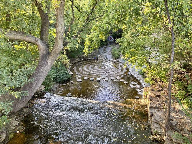
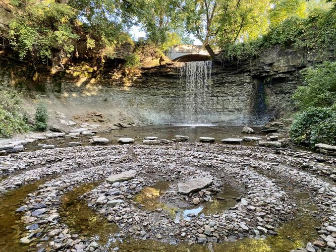
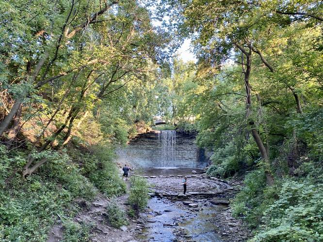
This is less of a hike and more of a walk that leads down into a creek gorge. The walk begins at the main parking are for Wequiock Falls County Park and follows the universal access paved path that leads around the north side of the park. Along the way is a nice view above the waterfall that peers into the Wequiock Creek below. Once the trail circles around the creek, the path leads down a set of stairs and out to a bridge that provides a view of Wequiock Falls and the spiral rock maze from downstream. For those willing to walk along the crumbling creek banks, the walk can lead to the base of Wequiock Falls and the spiral rock maze. Once at the waterfall, hikers can fully enjoy the 25 to 30-foot cascade of Wequiock Falls. Note that the waterfall cascades over a visible segment of the Niagara Escarpment rock formation. On the way back from the waterfall hikers can enjoy the painted eyes on the bridge that crosses Wequiock Creek.

Parking
Visitors can find a small parking lot at the coordinates provided. The lot is large enough for about 6 vehicles max.

Pets
Dogs are allowed if leashed and their waste should be carried out by the hiker.
  1. Parking

    44.568005, -87.87941
  2. Main Trailhead

    44.568005, -87.87941
  3. Wequiock Falls overlook

    44.568242, -87.8789
    Wequiock Falls overlook
  4. Wequiock Falls with spiral rock maze

    44.568406, -87.879167
    Wequiock Falls with spiral rock maze
  5. View of Wequiock Falls from wooden bridge

    44.568686, -87.879469
    View of Wequiock Falls from wooden bridge
No community routes found. To add your own hike as a Community Route for this Trail guide, leave a Trip Report with an attached GPX file.

Hazards

Ticks - Lyme Disease More Info (CDC)
Rockfalls / Ledges / or Scrambles

Seasons

All

Trip Reports

Trail Guide By:
Admin user profile picture
0.3 miles / 0.5 km
0.3 miles / 0.5 km
September 20, 2022
Hiking

Weather Forecast

In Green Bay, WI

Explore Hiking Trails

You May Also Like

Colorado's Million Dollar Highway - Plan a day's drive adventure along the iconic Million Dollar Highway in Colorado. Explore the best short trails, roadside stops, waterfalls, vistas, ghost towns, and hot springs within a ~6 hour road trip.
Explore

Colorado's Million Dollar Highway

Plan a day's drive adventure along the iconic Million Dollar Highway in Colorado. Explore the best short trails, roadside stops, waterfalls, vistas, ghost towns, and hot springs within a ~6 hour road trip.

Read
Glacier's Going-to-the-Sun Road - Discover the breathtaking beauty of Glacier National Park along the iconic Going-to-the-Sun Road. From stunning roadside stops to picturesque waterfalls and vistas, this engineering marvel offers endless opportunities for exploration.
Explore

Glacier's Going-to-the-Sun Road

Discover the breathtaking beauty of Glacier National Park along the iconic Going-to-the-Sun Road. From stunning roadside stops to picturesque waterfalls and vistas, this engineering marvel offers endless opportunities for exploration.

Read
New York's Best Waterfalls - Whether you're planning a day hike, roadside stop, or a leisurely short walk, this guide provides hikers, travelers, and locals alike with 63 different locations to over 100 scenic waterfalls to help plan your next adventure!
Explore

New York's Best Waterfalls

Whether you're planning a day hike, roadside stop, or a leisurely short walk, this guide provides hikers, travelers, and locals alike with 63 different locations to over 100 scenic waterfalls to help plan your next adventure!

Read

Before you boogie...

Find our trail guides useful? Consider becoming a Supporter to unlock perks!

MyHikes is an indie platform that makes exploring public trails easier for everyone. The platform has no investors, no ads, and is owned and operated by one person, Dave Miller. Dave has personally mapped and written over 1,800 trail guides on MyHikes for the public to explore. MyHikes has helped millions outdoor enthusiasts plan their next adventure.

But it takes a lot of time ๐Ÿ•ฆ, money ๐Ÿ’ฐ, work, and espresso shots โ˜• to run MyHikes, including hiking , mapping , writing , and publishing new trails with high-quality (accurate) information... along with software engineering (coding) the platform like building new features, website and mobile app development (iOS and Android), site maintainance . and much much more.

Supporters unlock website and mobile app perks with an annual one-time payment of $25 (you renew) ๐Ÿ˜Ž๐Ÿ‘. Or you can simply make a Donation of your choice. Otherwise, you can support us by telling your friends about MyHikes - both quick and free ๐ŸŽ‰

Admin user profile picture

Dave Miller
MyHikes Founder