Loading...

๐ŸŽ‰ Enjoy a Free 7-Day Supporter Trial and Unlock Exclusive Perks โ€” No Credit Card Required. Learn more.

Waverly Glen Falls

Directions
Map
Pictures
Send to App
Distance:
0.3 Miles / 0.5 km
Type:
Out-and-Back
Difficulty:
Easy
Time to Hike:
~9 minutes
Features:
Surface Type:
Universal Access
Park:
Waverly Glen Park
Town:
Waverly, New York
Directions:
42.009313, -76.555349
Added:
May 28, 2023
Updated:
June 11, 2023
Copy Trail Link Hiking this trail? Send a friend or family member a link to this trail guide for your own safety. Hike at your own risk (disclaimer)
Loading...
Loading...
50'

Total Change
50'

Ascent
50'

Descent

Download the Trail Route for Offline Use

Supporters get exclusive access to download trail routes to the MyHikes app for offline use. Stay prepared on your adventure, even without an internet connection! Become a Supporter today to unlock this feature and hike with confidence.

Send to App

Waverly Glen Falls

Waverly Glen Falls at Waverly Glen Park in Waverly, New York is an easy and accessible 0.3-mile out-and-back trail that leads to the 40-foot tall waterfall Waverly Glen Falls.

This is not a hike but rather a short walk that follows a universally accessible path. Hikers will pass a small waterfall in Dry Brook before the trail crosses a bridge, spanning the creek.

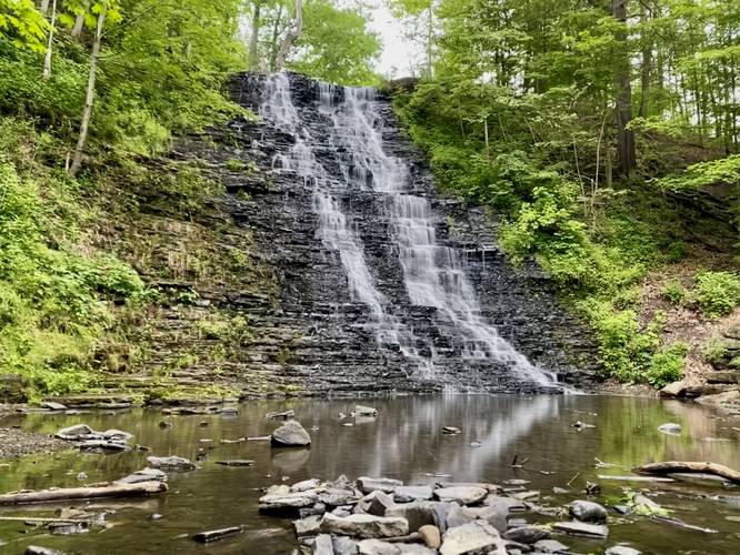
Waverly Glen Falls - Mile 0.15
Around mile 0.15, hikers will reach the base of Waverly Glen Falls. Waverly Glen Falls cascades down the ~40-foot shale rock ledge as it feeds Dry Brook. As of May 2023, there are a couple of benches at the base of the waterfall located ~10-feet above the creek. Hikers can scramble down the large boulders to reach Dry Brook for a different perspective if they wish and if the water level is low enough. Note that after periods of low rainfall and low Winter snow melt, Waverly Glen Falls can often be found dried up, hence the creek's name Dry Brook.

Universal Access
This trail starts out as a paved pathway but quickly changes to flat dirt and stone. The path should be considered universally accessible up to the viewing point with benches by the base of the waterfall.

Parking
Visitors will find parking at the coordinates provided at the far end of the entrance road to Waverly Glen Park.

Pets
Dogs are allowed only if leashed and must be cleaned up after.
Explore 79 trails near Waverly, NY
  1. Parking

    42.009313, -76.555349
  2. Main Trailhead

    42.009359, -76.555437
  3. Waverly Glen Falls (approx. 40-feet tall)

    42.010486, -76.556917
    Waverly Glen Falls (approx. 40-feet tall)
No community routes found. To add your own hike as a Community Route for this Trail guide, leave a Trip Report with an attached GPX file.

Hazards

Ticks - Lyme Disease More Info (CDC)

Seasons

All

Trip Reports

Trail Guide By:
Admin user profile picture
0.3 miles / 0.5 km
0.3 miles / 0.5 km
July 02, 2023
Hiking
0.3 miles / 0.5 km
July 02, 2023
Came back to finally find the waterfall flowing, took a couple of trips.
Hiking

Weather Forecast

In Waverly, NY

Explore Hiking Trails

You May Also Like

Colorado's Million Dollar Highway - Plan a day's drive adventure along the iconic Million Dollar Highway in Colorado. Explore the best short trails, roadside stops, waterfalls, vistas, ghost towns, and hot springs within a ~6 hour road trip.
Explore

Colorado's Million Dollar Highway

Plan a day's drive adventure along the iconic Million Dollar Highway in Colorado. Explore the best short trails, roadside stops, waterfalls, vistas, ghost towns, and hot springs within a ~6 hour road trip.

Read
Glacier's Going-to-the-Sun Road - Discover the breathtaking beauty of Glacier National Park along the iconic Going-to-the-Sun Road. From stunning roadside stops to picturesque waterfalls and vistas, this engineering marvel offers endless opportunities for exploration.
Explore

Glacier's Going-to-the-Sun Road

Discover the breathtaking beauty of Glacier National Park along the iconic Going-to-the-Sun Road. From stunning roadside stops to picturesque waterfalls and vistas, this engineering marvel offers endless opportunities for exploration.

Read
New York's Best Waterfalls - Whether you're planning a day hike, roadside stop, or a leisurely short walk, this guide provides hikers, travelers, and locals alike with 63 different locations to over 100 scenic waterfalls to help plan your next adventure!
Explore

New York's Best Waterfalls

Whether you're planning a day hike, roadside stop, or a leisurely short walk, this guide provides hikers, travelers, and locals alike with 63 different locations to over 100 scenic waterfalls to help plan your next adventure!

Read

Before you boogie...

Find our trail guides useful? Consider becoming a Supporter to unlock perks!

MyHikes is an indie platform that makes exploring public trails easier for everyone. The platform has no investors, no ads, and is owned and operated by one person, Dave Miller. Dave has personally mapped and written over 1,800 trail guides on MyHikes for the public to explore. MyHikes has helped millions outdoor enthusiasts plan their next adventure.

But it takes a lot of time ๐Ÿ•ฆ, money ๐Ÿ’ฐ, work, and espresso shots โ˜• to run MyHikes, including hiking , mapping , writing , and publishing new trails with high-quality (accurate) information... along with software engineering (coding) the platform like building new features, website and mobile app development (iOS and Android), site maintainance . and much much more.

Supporters unlock website and mobile app perks with an annual one-time payment of $25 (you renew) ๐Ÿ˜Ž๐Ÿ‘. Or you can simply make a Donation of your choice. Otherwise, you can support us by telling your friends about MyHikes - both quick and free ๐ŸŽ‰

Admin user profile picture

Dave Miller
MyHikes Founder