The Waterville Rock Slide at Tiadaghton State Forest in Waterville, Pennsylvania is a strenuous 0.8-mile out-and-back bushwhack hike that leads to a mountainside rock slide (talus slope) with views of the mountains in the PA Grand Canyon.
Vista
This bushwhack leads to a rock slide vista, the Waterville Rock Slide.
Bushwhack
This hike is a bushwhack that leads through a rocky boulder field forest floor before reaching the exposed mountainside rock slide. Only experienced bushwhack hikers with proper navigation and scrambling skills should attempt this hike. Trekking poles help immensely with the descent through the boulder field.
Hike Description
This hike begins along Ramsey Road near the parking coordintes provided, adjacent to a large game fence, as of April 2023. Hikers will head down the state forest service road with signage labeled "Gobbler Knob" and "2966" - this service road is also a private camp driveway; however, the first 0.3-miles of this road are public before it switches to private land.
Left-Hand Turn to Bushwhack - Mile 0.17
Hikers will hike down the service road for a very short while, no longer than approximately 0.15 miles until they reach a section of the forest with low-growing mountain laurel and white pines. Take a left-hand turn here to begin the difficult mountain descent.
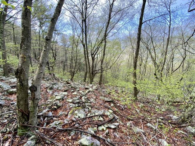
Boulder Field Scramble - Mile 0.3
Around mile 0.3 from parking, hikers will have bushwhacked through mountain laurel along the steep mountainside until they reach a wide-spread boulder field that litters the forest floor. Here, you'll start the slow descent as each step counts - you must check each step before committing as there are often large unseen voids between the boulders. You can use your trekking poles to poke around and act as extendable crutches to lower yourself safely as you descend the steep rocky slopes. Also note that some of these rocks can come loose, sending you down the mountain.
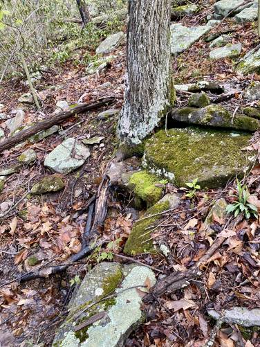
Miller Spring - Mile 0.32
At mile 0.32, if you happen to follow this same exact route, is a hidden mountainside spring, Miller Spring.
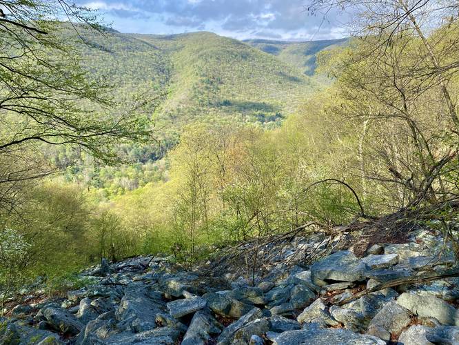
Waterville Rock Slide & Vista - Mile 0.4
Finally, after making the painstakingly-annoying 475-foot descent, hikers will reach the Waterville Rock Slide which provides a neat vista of the surrounding mountains around Pine Creek in the PA Grand Canyon. The rock slide has plenty of open space for hikers to scramble around to explore and get different, but similar, views of the mountains surrounding Pine Creek. The Waterville Rock Slide appears to be a mountainside talus slope, which are formed from glacial activity. Hikers should sit here for a bit to enjoy the view before starting the even-harder ascent back up the mountain.
Scramble Ascent
After checking out the view from the Waterville Rock Slide, hikers will have to scramble their way back 475-feet up the mountain in just 0.25-miles. Most of this climb is literally scrambling up the conglomerate rock boulders, but can often be sketchy with some loose rocks. During the warmer months and hot weather, these rocks could be home to Timber Rattlesnakes, so it's smart to watch every step and hand-hold, especially on the ascent. The scramble back up the mountain takes more energy out of you and will make you sweat like crazy, but is "easier" than the annoying slow descent down the boulder field for different reasons.
Parking
Hikers will find a parking turnout near the coordinates provided along Ramsey Road in Tiadaghton State Forest. The turnout is located adjacent to, as of April 2023, a metal game fence surrounding a barren landscape which used to be a holding pond for fracking operations and was filled-in. Do not block the service road gate as this gate is used by a private owner and state forest operations.
Pets
Dogs are allowed if leashed and must be cleaned up after. Note the difficult terrain - dogs are probably best kept at home for this hike.
Warnings
Bushwhack: This hike is an off-trail bushwhack and only for experienced hikers who are comfortable with this type of exploring.
Steep, Rock Terrain: This off-trail bushwhack leads along a very steep mountain side and through boulder fields that have large voids and cavities between the rocks along with loose rocks that can send the hiker down the mountain fairly easily. Each step must be taken with assurance and it's smart to bring trekking poles to aid in the descent.
Timber Rattlesnake: This area is home to the Timber Rattlesnake which often find homes in rocky outcroppings like this mountain rock slide; however, that doesn't mean rattlesnakes live here. Hikers could find them anywhere in these woods between April and October each year as they roam the forest. Watch out in rocky areas and especially in sunny rocky outcroppings for rattlesnakes.
Vista
This bushwhack leads to a rock slide vista, the Waterville Rock Slide.
Bushwhack
This hike is a bushwhack that leads through a rocky boulder field forest floor before reaching the exposed mountainside rock slide. Only experienced bushwhack hikers with proper navigation and scrambling skills should attempt this hike. Trekking poles help immensely with the descent through the boulder field.
Hike Description
This hike begins along Ramsey Road near the parking coordintes provided, adjacent to a large game fence, as of April 2023. Hikers will head down the state forest service road with signage labeled "Gobbler Knob" and "2966" - this service road is also a private camp driveway; however, the first 0.3-miles of this road are public before it switches to private land.
Left-Hand Turn to Bushwhack - Mile 0.17
Hikers will hike down the service road for a very short while, no longer than approximately 0.15 miles until they reach a section of the forest with low-growing mountain laurel and white pines. Take a left-hand turn here to begin the difficult mountain descent.
Boulder Field Scramble - Mile 0.3
Around mile 0.3 from parking, hikers will have bushwhacked through mountain laurel along the steep mountainside until they reach a wide-spread boulder field that litters the forest floor. Here, you'll start the slow descent as each step counts - you must check each step before committing as there are often large unseen voids between the boulders. You can use your trekking poles to poke around and act as extendable crutches to lower yourself safely as you descend the steep rocky slopes. Also note that some of these rocks can come loose, sending you down the mountain.
Miller Spring - Mile 0.32
At mile 0.32, if you happen to follow this same exact route, is a hidden mountainside spring, Miller Spring.
Waterville Rock Slide & Vista - Mile 0.4
Finally, after making the painstakingly-annoying 475-foot descent, hikers will reach the Waterville Rock Slide which provides a neat vista of the surrounding mountains around Pine Creek in the PA Grand Canyon. The rock slide has plenty of open space for hikers to scramble around to explore and get different, but similar, views of the mountains surrounding Pine Creek. The Waterville Rock Slide appears to be a mountainside talus slope, which are formed from glacial activity. Hikers should sit here for a bit to enjoy the view before starting the even-harder ascent back up the mountain.
Scramble Ascent
After checking out the view from the Waterville Rock Slide, hikers will have to scramble their way back 475-feet up the mountain in just 0.25-miles. Most of this climb is literally scrambling up the conglomerate rock boulders, but can often be sketchy with some loose rocks. During the warmer months and hot weather, these rocks could be home to Timber Rattlesnakes, so it's smart to watch every step and hand-hold, especially on the ascent. The scramble back up the mountain takes more energy out of you and will make you sweat like crazy, but is "easier" than the annoying slow descent down the boulder field for different reasons.
Parking
Hikers will find a parking turnout near the coordinates provided along Ramsey Road in Tiadaghton State Forest. The turnout is located adjacent to, as of April 2023, a metal game fence surrounding a barren landscape which used to be a holding pond for fracking operations and was filled-in. Do not block the service road gate as this gate is used by a private owner and state forest operations.
Pets
Dogs are allowed if leashed and must be cleaned up after. Note the difficult terrain - dogs are probably best kept at home for this hike.
Warnings
Bushwhack: This hike is an off-trail bushwhack and only for experienced hikers who are comfortable with this type of exploring.
Steep, Rock Terrain: This off-trail bushwhack leads along a very steep mountain side and through boulder fields that have large voids and cavities between the rocks along with loose rocks that can send the hiker down the mountain fairly easily. Each step must be taken with assurance and it's smart to bring trekking poles to aid in the descent.
Timber Rattlesnake: This area is home to the Timber Rattlesnake which often find homes in rocky outcroppings like this mountain rock slide; however, that doesn't mean rattlesnakes live here. Hikers could find them anywhere in these woods between April and October each year as they roam the forest. Watch out in rocky areas and especially in sunny rocky outcroppings for rattlesnakes.