The Water Tank Falls via Water Tank Trail hike at Tioga State Forest near Morris, Pennsylvania is a difficult, and slightly dangerous, 4-mile out-and-back trail that leads down Water Tank Hollow to two very large waterfalls - Water Tank Falls (approx. 35 feet tall), and Upper Water Tank Falls aka Twin Falls (approx. 80-100 feet tall).
Trails
This hike follows three named trails and one unofficial trail in order: Mid State Trail (orange blazes), Water Tank Trail (yellow blazes), Pine Creek Trail, and finally the unofficial and unnamed trail that leads up Water Tank Hollow aka Water Tank Hollow Trail.
Hike Description
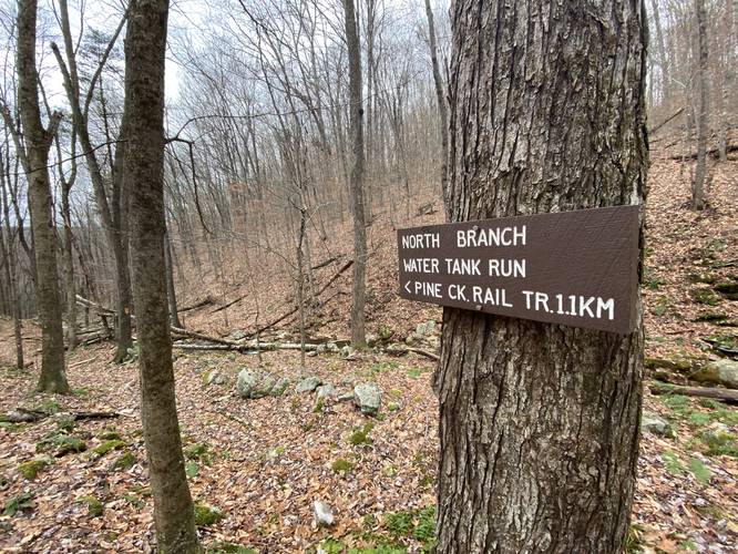
This hike begins along Clay Mine Road near the Mid State Trail parking area at the parking coordinates provided and follows the Mid State Trail (orange blazes) south for approximately 0.9-miles before reaching the trail junction with the Water Tank Trail (yellow blazes).
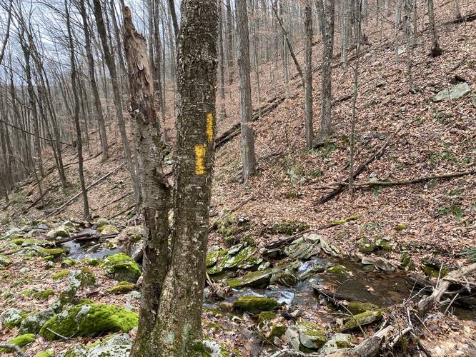
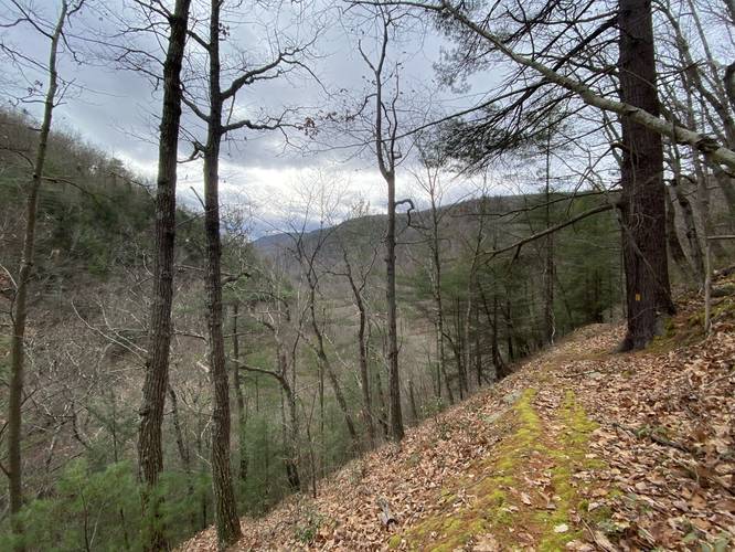
Water Tank Trail (yellow blazes) - mile 0.9 to ~mile 1.7
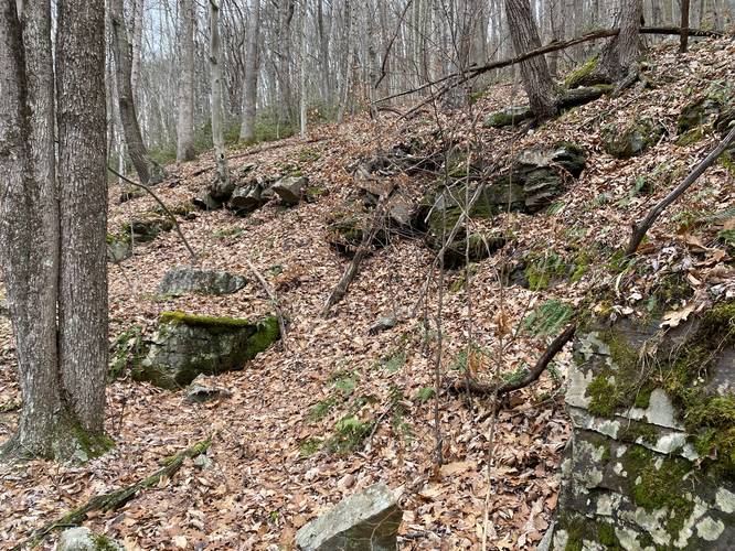
Once one the Water Tank Trail, hikers will quickly cross North Branch Water Tank Run before the trail follows a very narrow path as it heads down the hollow. The hillsides along most of the Water Tank Trail are very steep and can be considered dangerous if you lose your footing. Around mile 1.25 from the Mid State Trail trailhead, hikers will notice an old quarry site where the stone on the side of the hill was cut into - with some stone discarded down the mountainside.
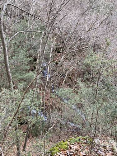
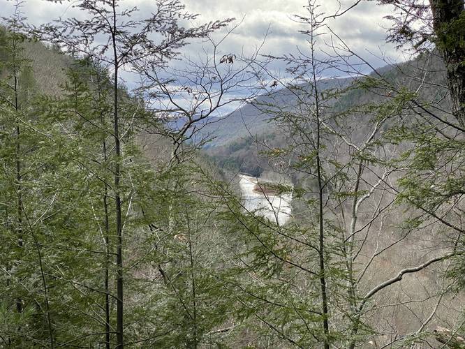
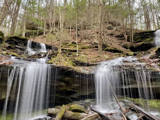
Upper Water Tank Falls View (no foliage-only) - mile 1.45
Around mile 1.45 is an off-shoot deer trail that runs off of the Water Tank Trail and down to a rock ledge. This rock ledge, during late Autumn, Winter, and early Spring, gives hikers a view of the entirety of Upper Water Tank Falls aka Twin Falls. The right-hand side of the waterfall is by far the most interesting as it continues up the mountainside for as far as the eye can see - leaving the hiker understanding that the Upper Water Tank Falls is at least 80 to 100 feet tall, based on the portion visible from this rock ledge. Note that these sections of the waterfall are not visible from the base of Upper Water Tank Falls.
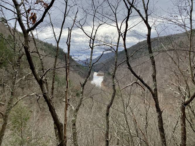
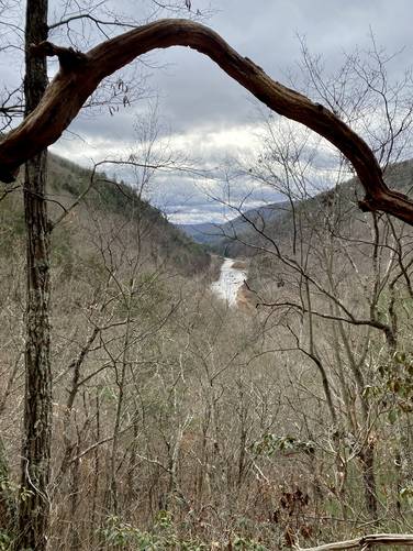
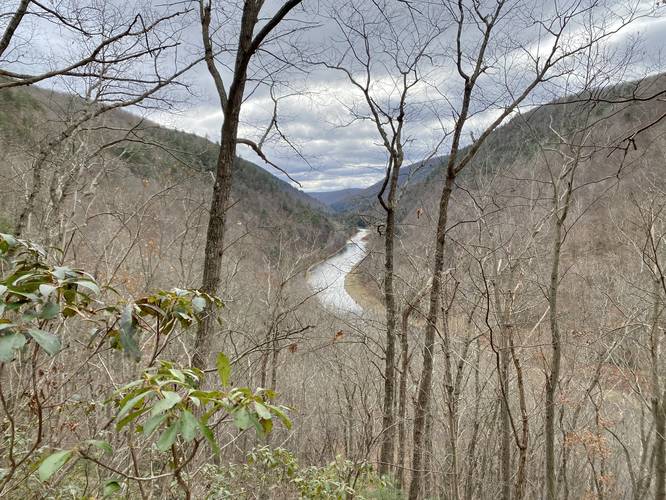
Seasonal Vistas - mile 1.5 to 1.65
Between miles 1.5 and 1.65 (including the off-shoot rock ledge portion), hikers will find about five seasonal vistas that have views of Pine Creek, the canyon (PA Grand Canyon / Pine Creek Gorge), and the Pine Creek Trail below.
Switchbacks to Pine Creek Trail
After visiting or passing-by the seasonal vista area, the Water Tank Trail will follow a switchback as it heads down to the Pine Creek Trail. Watch your step as parts of this trail are a bit steep and slippery.
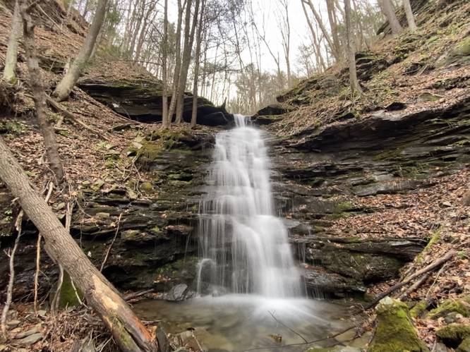
Reaching Water Tank Falls - mile 2.85 to mile 2
Once on the Pine Creek Trail, hikers will cross the old railroad bridge to find a sign labeled 'Water Tank Hollow'. Here, hikers will find an unofficial trail that heads up the hollow to reach the lower 35-40 foot tall Water Tank Falls. The trail to reach the waterfall includes a small uphill climb that features a rope, making it easier to climb. Water Tank Falls, is about 35 to 40 feet tall and no more than 10-feet wide at the base. The pool below is not very large, but this makes for a great spot to stop and rest while taking in the scenery.
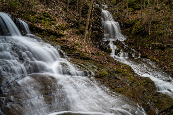
Reaching Upper Water Tank Falls / Twin Falls - very dangerous
Hikers will notice (as of Dec 2021), a rope heading uphill alongside the very steep hillside next to Water Tank Falls. This "trail" is the only way hikers can reach the base of Upper Water Tank Falls aka Twin Falls, but is extremely dangerous. The footing is very narrow, often wet and slippery, while covered in leaves. For those afraid of heights, reaching Upper Water Tank Falls can be a bit terrifying, but if you go very slow and take your time, its worth it in the end. After climbing the 50-foot hillside next to the lower falls, the Upper Water Tank Falls aka Twin Falls comes into clear view with both waterfalls converging at one point to form their own waterfall just upstream from Water Tank Falls. I've nicknamed this upper waterfall Twin Falls for obvious reasons. The total height of the waterfall(s) is about 100-feet or more. Viewing the height from the base of Twin Falls, the left-hand side is about 45 to 50-feet tall in total. The right-hand side is only partially visible (as noted earlier) with about 50-feet total that can be seen from the base; however, the right-hand side of Twin Falls continues for another 50-feet or more - making this entire waterfall approximately 100-feet. As noted, reaching this waterfall is very dangerous as one false move could lead the hiker to plummet 50-feet into the ravine below with no cell phone service and very-little chance of getting help.
Hiking Out
Obviously the hike out is identical but opposite to the hike in. Honestly, the hike out is much easier except for the ~1,200-foot climb out of the PA Grand Canyon and back to the trailhead.
Warnings
Steep terrain: this trail (Water Tank Trail, Water Tank Hollow) includes some very steep and dangerous terrain. Proper footwear and trekking poles are recommended for this hike.
Rattlesnakes: this area is home to the Timber Rattlesnake. Because of the rock ledges and creek hiking that this trail includes, hikers will want to stay on the lookout for rattlesnakes between the months of late-April to early-October.
Hunting: while there's technically no hunting allowed in this section of the PA Grand Canyon, hikers may find hunters during Autumn here. Wear orange and make your presence known regardless to keep from getting accidentally shot.
Parking
Hikers will find parking near the coordinates provided at the Mid State Trail parking lot. The lot is large enough for about 5 vehicles max.
Camping and Backpacking
This trail allows camping and backpacking, but there were no pre-defined campsites setup along either trail when hiked in December 2021. The Water Tank Trail is not a trail to camp off of due to the steep terrain. Hikers may be able to setup a campsite along the Mid State Trail portion of this hike along flat ground. Please follow all state forest rules and regulations when backcountry / primitive / dispersed camping.
History
During the logging era, there used to be railroad that ran through the valley of the PA Grand Canyon and presumably, the railroad had a water tank for steam locomotives at the bottom which were refilled from the stream, hence the name of the trail and the waterfalls.
Trails
This hike follows three named trails and one unofficial trail in order: Mid State Trail (orange blazes), Water Tank Trail (yellow blazes), Pine Creek Trail, and finally the unofficial and unnamed trail that leads up Water Tank Hollow aka Water Tank Hollow Trail.
Hike Description
This hike begins along Clay Mine Road near the Mid State Trail parking area at the parking coordinates provided and follows the Mid State Trail (orange blazes) south for approximately 0.9-miles before reaching the trail junction with the Water Tank Trail (yellow blazes).
Water Tank Trail (yellow blazes) - mile 0.9 to ~mile 1.7
Once one the Water Tank Trail, hikers will quickly cross North Branch Water Tank Run before the trail follows a very narrow path as it heads down the hollow. The hillsides along most of the Water Tank Trail are very steep and can be considered dangerous if you lose your footing. Around mile 1.25 from the Mid State Trail trailhead, hikers will notice an old quarry site where the stone on the side of the hill was cut into - with some stone discarded down the mountainside.
Upper Water Tank Falls View (no foliage-only) - mile 1.45
Around mile 1.45 is an off-shoot deer trail that runs off of the Water Tank Trail and down to a rock ledge. This rock ledge, during late Autumn, Winter, and early Spring, gives hikers a view of the entirety of Upper Water Tank Falls aka Twin Falls. The right-hand side of the waterfall is by far the most interesting as it continues up the mountainside for as far as the eye can see - leaving the hiker understanding that the Upper Water Tank Falls is at least 80 to 100 feet tall, based on the portion visible from this rock ledge. Note that these sections of the waterfall are not visible from the base of Upper Water Tank Falls.
Seasonal Vistas - mile 1.5 to 1.65
Between miles 1.5 and 1.65 (including the off-shoot rock ledge portion), hikers will find about five seasonal vistas that have views of Pine Creek, the canyon (PA Grand Canyon / Pine Creek Gorge), and the Pine Creek Trail below.
Switchbacks to Pine Creek Trail
After visiting or passing-by the seasonal vista area, the Water Tank Trail will follow a switchback as it heads down to the Pine Creek Trail. Watch your step as parts of this trail are a bit steep and slippery.
Reaching Water Tank Falls - mile 2.85 to mile 2
Once on the Pine Creek Trail, hikers will cross the old railroad bridge to find a sign labeled 'Water Tank Hollow'. Here, hikers will find an unofficial trail that heads up the hollow to reach the lower 35-40 foot tall Water Tank Falls. The trail to reach the waterfall includes a small uphill climb that features a rope, making it easier to climb. Water Tank Falls, is about 35 to 40 feet tall and no more than 10-feet wide at the base. The pool below is not very large, but this makes for a great spot to stop and rest while taking in the scenery.
Reaching Upper Water Tank Falls / Twin Falls - very dangerous
Hikers will notice (as of Dec 2021), a rope heading uphill alongside the very steep hillside next to Water Tank Falls. This "trail" is the only way hikers can reach the base of Upper Water Tank Falls aka Twin Falls, but is extremely dangerous. The footing is very narrow, often wet and slippery, while covered in leaves. For those afraid of heights, reaching Upper Water Tank Falls can be a bit terrifying, but if you go very slow and take your time, its worth it in the end. After climbing the 50-foot hillside next to the lower falls, the Upper Water Tank Falls aka Twin Falls comes into clear view with both waterfalls converging at one point to form their own waterfall just upstream from Water Tank Falls. I've nicknamed this upper waterfall Twin Falls for obvious reasons. The total height of the waterfall(s) is about 100-feet or more. Viewing the height from the base of Twin Falls, the left-hand side is about 45 to 50-feet tall in total. The right-hand side is only partially visible (as noted earlier) with about 50-feet total that can be seen from the base; however, the right-hand side of Twin Falls continues for another 50-feet or more - making this entire waterfall approximately 100-feet. As noted, reaching this waterfall is very dangerous as one false move could lead the hiker to plummet 50-feet into the ravine below with no cell phone service and very-little chance of getting help.
Hiking Out
Obviously the hike out is identical but opposite to the hike in. Honestly, the hike out is much easier except for the ~1,200-foot climb out of the PA Grand Canyon and back to the trailhead.
Warnings
Steep terrain: this trail (Water Tank Trail, Water Tank Hollow) includes some very steep and dangerous terrain. Proper footwear and trekking poles are recommended for this hike.
Rattlesnakes: this area is home to the Timber Rattlesnake. Because of the rock ledges and creek hiking that this trail includes, hikers will want to stay on the lookout for rattlesnakes between the months of late-April to early-October.
Hunting: while there's technically no hunting allowed in this section of the PA Grand Canyon, hikers may find hunters during Autumn here. Wear orange and make your presence known regardless to keep from getting accidentally shot.
Parking
Hikers will find parking near the coordinates provided at the Mid State Trail parking lot. The lot is large enough for about 5 vehicles max.
Camping and Backpacking
This trail allows camping and backpacking, but there were no pre-defined campsites setup along either trail when hiked in December 2021. The Water Tank Trail is not a trail to camp off of due to the steep terrain. Hikers may be able to setup a campsite along the Mid State Trail portion of this hike along flat ground. Please follow all state forest rules and regulations when backcountry / primitive / dispersed camping.
History
During the logging era, there used to be railroad that ran through the valley of the PA Grand Canyon and presumably, the railroad had a water tank for steam locomotives at the bottom which were refilled from the stream, hence the name of the trail and the waterfalls.